Weather Improves Gusty Winds Some Sunshine
Snow Showers Tonight Dry Monday
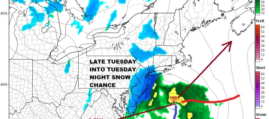
Chance Snow Rain Tuesday
Finally after spending the first half of the weekend in gloom and doom with low clouds, dense fog, and occasional rain, we are seeing a strengthening storm this morning south of Nova Scotia. That has whipped up a rather busy wind today but we can also see some strips of clearing on the satellite picture, at least for the time being. We are looking for some breaks of sunshine today. The problem is that we have the next weather system already on its way across the Great Lakes. As one system departs and takes clouds out the the east, another arrives with clouds to the west. Temperatures today will be in the upper 30s and lower 40s with this gusty wind making it feel 10 degrees colder.
SATELLITE

REGIONAL RADAR

You can see the gap between the two weather systems on the satellite picture this morning. At least there are no rain or snow issues today. Radars are mostly quiet both regionally and locally though we are seeing a little lake effect action going on in parts of Southwestern NY.
LOCAL RADAR NEW YORK CITY

LOCAL RADAR PHILADELPHIA


The weather system tonight is a weak frontal system and upper trough that will be swinging through and there will be some snow showers with this scattered around during the early morning hours into daybreak.

These snow showers don’t amount to much. Some places might see a coating of snow out of this but not much more. Then weather conditions improve after this system goes by tomorrow morning and we should see some sunshine develop from midday through the afternoon. Highs will be in the upper 30s to mid 40s in most places. Our attention then turns to Tuesday as low pressure comes out of the Tennessee Valley with a developing area of snow and rain while energy from the Great Lakes drops southeastward.

The low will be gathering some energy from the northern stream feature moving across the Great Lakes and that creates a strengthening low that heads into the Gulf of Maine by Wednesday. While the surface temperatures are borderline, the temperatures aloft are very cold. Also this run of the nam is rather robust with precipitation especially over South Jersey and from Eastern Long Island eastward. If snow lovers play their cards right this could produce a few inches for someone from Eastern Pennsylvania to Southern New England. Overnight European and Canadian models would go along with this idea and even the GFS is on a similar page here. We will be looking at this closely this afternoon as the new round of models come out. In a pattern like this snow comes when everything lines up perfectly even though the overall pattern is not favorable for snow events. Sometimes windows of opportunity open up and we may have one such window here for later Tuesday and Tuesday night. Cold weather will be here for Wednesday and Thursday before the next round of changes develop for the weekend.
BE SURE TO DOWNLOAD THE FREE METEOROLOGIST JOE CIOFFI WEATHER APP &
ANGRY BEN’S FREE WEATHER APP “THE ANGRY WEATHERMAN!
MANY THANKS TO TROPICAL TIDBITS FOR THE USE OF MAPS
Please note that with regards to any severe weather, tropical storms, or hurricanes, should a storm be threatening, please consult your local National Weather Service office or your local government officials about what action you should be taking to protect life and property.


