Weather Conditions Slow to Improve Today Weekend Low Humidity Nice Overall
Last night’s cold front produced some rare nighttime severe weather from Northern New Jersey to Long Island. Thunderstorms on Long Island actually produce considerable damage with unverified wind gusts as high as 80 or 90 mph. We are waiting to see a complete list of storm reports but we had trees taken down, a wall collapse on a building, and power outages. Today is a recovery day but we are waiting for last night’s cold front to sink a little further south so the dry air and clear skies that are on the satellite picture in upstate NY can move southward. It may take all day for the clearing line to advance but it will eventually get here either this afternoon or this evening. In the meantime temperatures will be holding in the 70s all day as humidity levels edge lower.
SATELLITE

REGIONAL RADAR

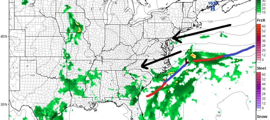
We are also dealing with an area of rain from Southern New England to Southern Pennsylvania. There is a weak low on the cold front that has to move out to the east and take this area offshore. Dry air is also eating away at the rain shield and we should see this rain disappear as the day wears on.
LOCAL RADAR NEW YORK CITY

LOCAL RADAR PHILADELPHIA 

Skies will clear out tonight and the humidity nosedives. Lows will be in the 50s except for low 60s in thw warmer urban areas. Saturday looks like a beautiful day with lots of sunshine, low humidity and high temperatures in the very pleasant 70s. There will also be a nice northeast breeze. You couldn’t ask for a better day.

Sunday has become a bit tricky with the high to the northeast in the Gulf of Maine creating an onshore flow. The frontal boundary is going to be stalled to our south. It is far enough south to spare us any major issues. However the easterly flow and a weak upper air disturbance might trigger a few clouds. Im going for partly sunny skies for Sunday especially inland. There is an outside chance for a coastal spot shower. Overall I’m still being optimistic on Sunday. Highs will be cool though with temperatures topping in the low to mid 70s.
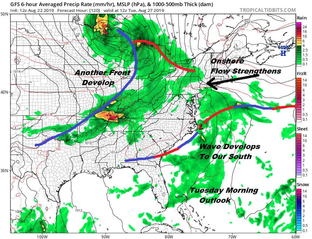
Going into next week we will be watching the next systems swinging into the Great Lakes while the stalled frontal boundary gives birth to a wave of low pressure. Look for arriving clouds and slowly rising humidity with highs in the 70s. We think there could be a few showers Monday night into Tuesday depending on what this wave does. Also we are watching disturbed weather off the Florida east coast. Conditions are becoming favorable for tropical storm formation here. We will be monitoring this over the weekend and we will address what it means weather wise for the East Coast later today.
MANY THANKS TO TROPICAL TIDBITS FOR THE USE OF MAPS
Please note that with regards to any tropical storms or hurricanes, should a storm be threatening, please consult your local National Weather Service office or your local government officials about what action you should be taking to protect life and property.


