Weather Conditions Should Improve Overnight & Tuesday
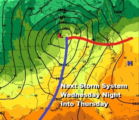
Next Storm System Arrives Wednesday Night & Thursday
We struggled all day with lots of clouds and we continue to struggle this evening with the back edge of clouds. This is all thanks to a storm offshore east of Cape Cod that is only now starting to edge away to the east. It kept temperatures locked in today in the upper 40s and lower 50s. There wasn’t much rain around but with the upper low going by this evening we are picking up the back edge of precipitation moving southeastward.
SATELLITE

REGIONAL RADAR

You can see the patchy rain on the regional and local radars that is moving southeast from New England and upstate NY. This rain is light and it is the last of the rain from the coastal low. Once this gets far enough to the east later tonight the showers will disappear and skies should partially clear out by morning.
LOCAL RADAR NEW YORK CITY

LOCAL RADAR PHILADELPHIA


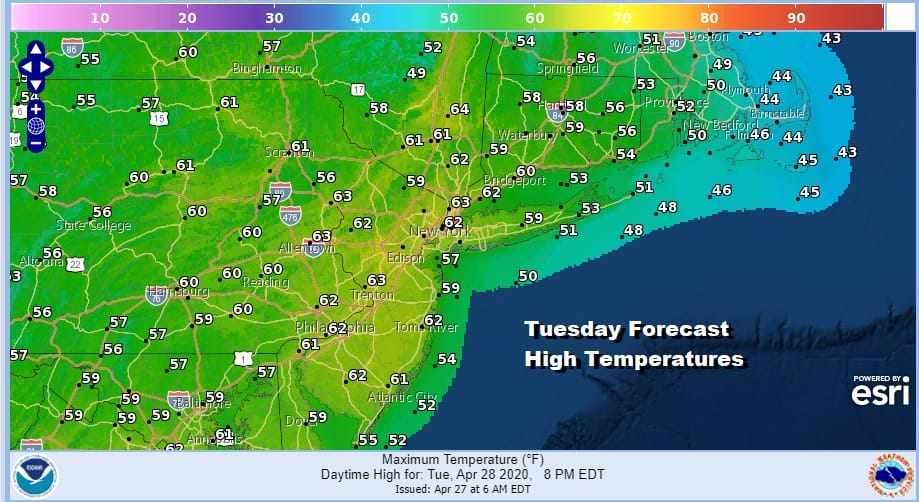
It will be a chilly night but in line with what has been going on lately. Most lows will be in the mid 30s to lower 40s. We should see some sunshine on Tuesday though a weakening disturbance moving southeast from the Great Lakes has me concerned regarding clouds especially south of NYC. Highs will reach the lower 60s where we see sunshine but the further south you go the more clouds you will see and temperatures in Southern Pennsylvania and Southern New Jersey south probably will have a tough time getting out of the 50s.
Wednesday we begin to look to the west with another storm system approaching. There will be a warm front to the south and a cold front to the west and both will have some impact here. The warm front is not going to be fighting a strong onshore flow this time around though there will be southeast winds ahead of it on Wednesday. Clouds will increase. Temperatures will likely be in the 50s with 60s well inland.
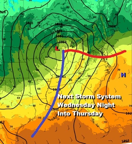
My guess is that Wednesday should be rain free during the day and showers and possibly a few thunderstorms won’t arrive until during the day Thursday. The front is slow moving and we could see showers lasting into very early Friday morning before the front passes far enough to the east. Highs Thursday will be in the 60s.

There still may be some showers lingering around on Friday but they should be widely scattered and mostly inland. Leftover clouds might give way to some sunshine with highs in the 60s. Right now I’m going to be cautiously optimistic for the weekend that we could have two reasonably nice spring days with sunshine. Saturday’s highs will be in the 60s but perhaps on Sunday with a little luck we could see temperatures reach into the 70s.
BE SURE TO DOWNLOAD THE FREE METEOROLOGIST JOE CIOFFI WEATHER APP &
ANGRY BEN’S FREE WEATHER APP “THE ANGRY WEATHERMAN!
MANY THANKS TO TROPICAL TIDBITS FOR THE USE OF MAPS
Please note that with regards to any severe weather, tropical storms, or hurricanes, should a storm be threatening, please consult your local National Weather Service office or your local government officials about what action you should be taking to protect life and property.


