
Warmer Tuesday Dry Until Late Friday Christmas Questions
SHOP THE JOESTRADAMUS STORE
Warmer Tuesday Dry Until Late Friday Christmas Questions
At least there are no snow events to worry about this week. In fact if your snow cover isn’t gone yet it will be gone by Tuesday afternoon. A warm front is passing through and we will be in the milder air mass for about 24 hours. Tonight skies should partially clear but temperatures won’t go far as they drop into the 30s to near 40 in most places. The satellite loop shows cloud cover to our north and east and some patchy clouds to the west but no precipitation is forecast until probably late Friday so the radars will be nice and quiet for a few days.
SATELLITE LOOP

REGIONAL RADAR

Tuesday is looking nice and mild with sun and clouds and highs will be in the low to mid 50s in most areas. The cold front coming through has very little with it other than a few clouds. It will turn colder Wednesday and Thursday with some sunshine both days. Most highs will be in the lower 40s Wednesday and just in the 30s on Thursday.
GFS MODEL SATURDAY DECEMBER 23, 2017
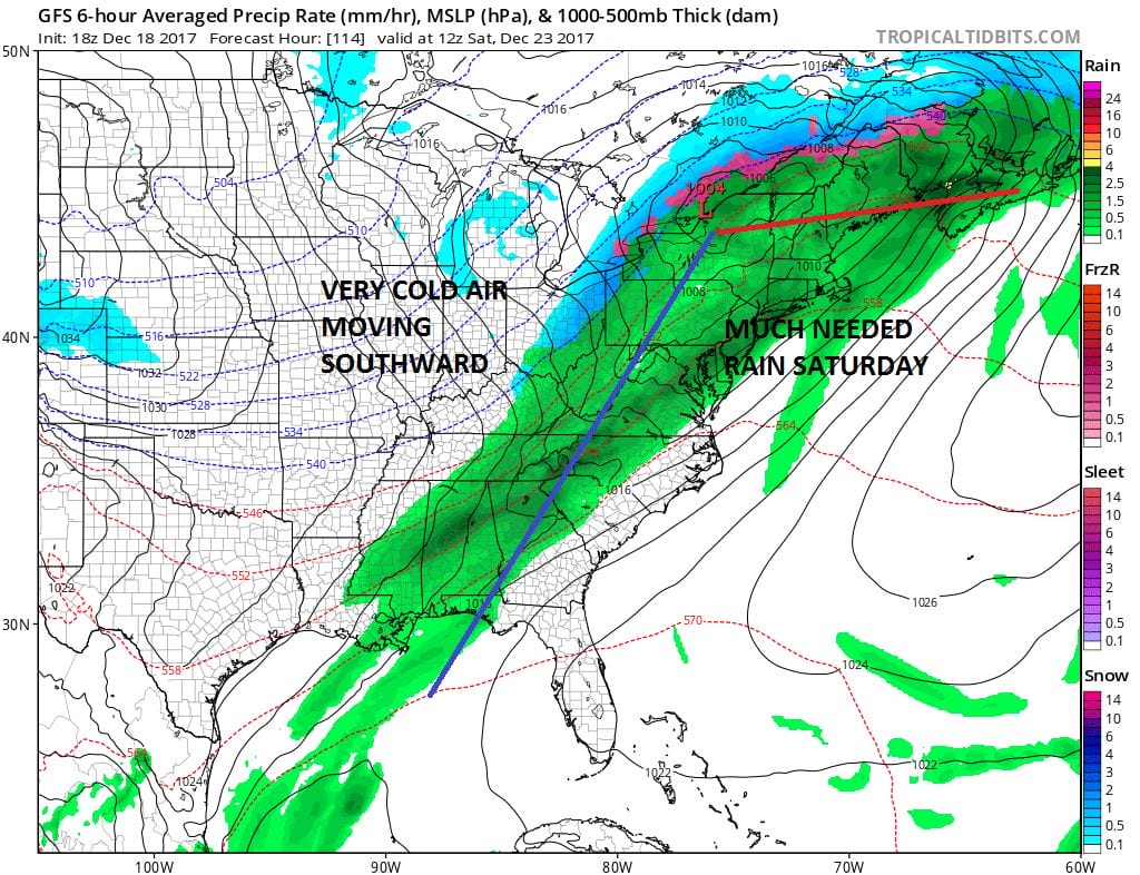
The next weather system approaches on Friday with arriving clouds here and some showers Friday night. Temperatures will begin to rise on Friday and ahead of the front Saturday we could see temperatures close to 60 before the front passes. It will turn colder on Sunday Christmas Eve. This front stalls to our south and another wave develops on it. The cold air to the west is quite impressive however if the push colder air is more south than east, then we could see rain rather than snow for late Sunday Christmas Eve into Christmas Day.
Weather models have been going back and forth on which way the push of cold air will be. Today’s weather models clearly point to a southward push rather than east but the atmosphere remains in a very volatile state and a shift to the east in the extent of cold air is not impossible. The GFS model is the coldest model of all the major models and even this model argues against snow as the push of cold air remains mainly to our west.
For more on the dimming chances for a White Christmas, see JOESTRADMUS & his latest post.
 GET JOE A CIGAR IF YOU LIKE

FiOS1 News Weather Forecast For Long Island
FiOS1 News Weather Forecast For New Jersey
FiOS1 News Weather Forecast For Hudson Valley


