Warmer Tuesday Colder Wednesday Long Range
SHOP THE JOESTRADAMUS STORE
Warmer Tuesday Colder Wednesday Long Range
Warmer Tuesday Colder Wednesday Long Range

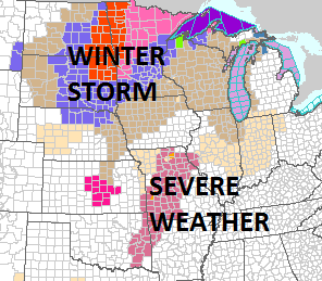
We are beginning to see clouds coming in from the west this evening as a strong storm heads for the Western Great Lakes. The weather across much of the US has been so quiet for the last 12 days but that is about to come to an end as the first in a series of cold air masses will starting moving southward. Ahead of that we will see clouds thicken late tonight as temperatures hold in the mid 30s to mid 40s. The overnight should be dry. The satellite loop is showing the clouds making steady progress to the east.
SATELLITE LOOP

REGIONAL RADAR

We don’t expect any showers here until just before daybreak on Tuesday. We will see some showers around on Tuesday but not an all day rain. Tuesday will be a warm day ahead of that cold front so highs will reach the 50s to near 60 in some spots. Showers will become more numerous Tuesday night but the front should be through long before sunrise on Wednesday. There is an outside chance the rain could end as a little sleet or wet snow north and west of the coast but even if that does happen it won’t amount to anything. Rainfall amounts from this front should be in the half to 3/4 inch range.

Wednesday will be a breezy colder day as the first of several cold air masses start to impact our weather over the next 2 weeks. Look for some sunshine to develop Wednesday as temperatures start the day in the 50s and fall to the upper 30s and lower 40s by the end of the day. Thursday will be cold with some sun and clouds with highs in the upper 30s and lower 40s.
We continue to watch the end of the week and the weekend with interest regarding the stalled front to the Southeast and energy coming in from the west. JOESTRADAMUS has more on this in his long range outlook.
 GET JOE A CIGAR IF YOU LIKE

FiOS1 News Weather Forecast For Long Island
FiOS1 News Weather Forecast For New Jersey
FiOS1 News Weather Forecast For Hudson Valley
NATIONAL WEATHER SERVICE SNOW FORECASTS
LATEST JOESTRADAMUS ON THE LONG RANGE


