Warmer Into Thursday Rain Ice Snow Chance Friday

Weather in 5/Joe & Joe Weather Show Latest Podcast
Warmer Into Thursday Rain Ice Snow Chance Friday
A new week and the last day of a cold and rather stormy month begin cold but we will start to see temperatures start to slowly warm as we move through the week. The core of the latest cold air mass that came in the wake of the blizzard is going to be moving out today. We will have sunshine and after the cold start, highs will be in the upper 20s to lower 30s. Considering how cold it has been, it will feel much better today especially since the wind is not a factor.
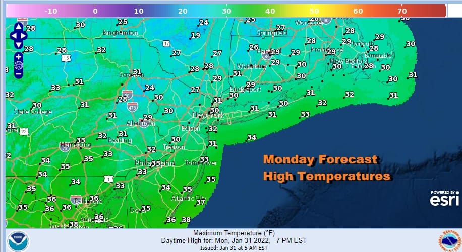
We really don’t see any big weather problems into Thursday. Temperatures will be slowly making their way higher over the next several days. Snow cover will likely slow the warm up down somewhat. Skies tonight will be clear and it won’t be as cold with most lows in teens to lower 20s. Highs Tuesday will be in the 30s. Tuesday night into Wednesday and onshore flow will put us in clouds. Temperatures Wednesday will reach the 40s.
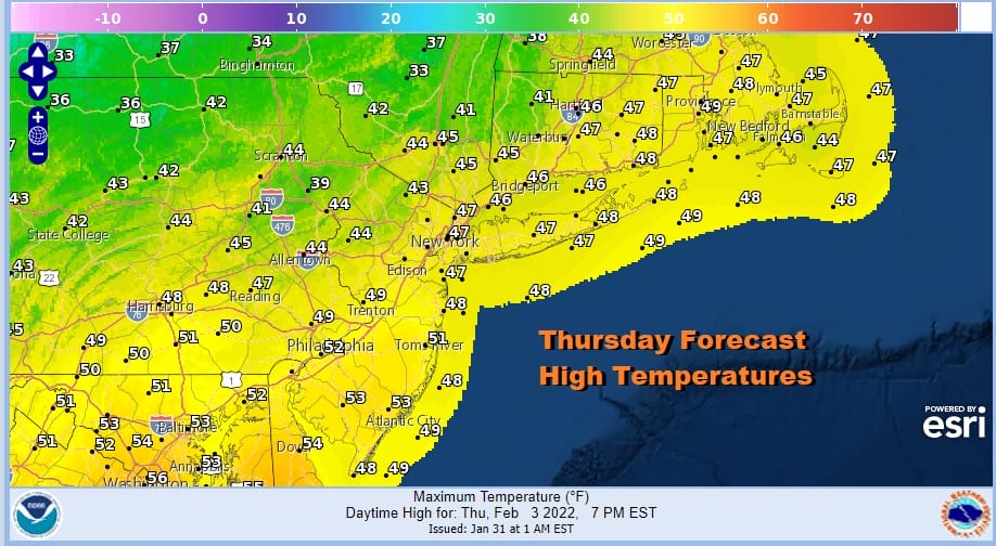
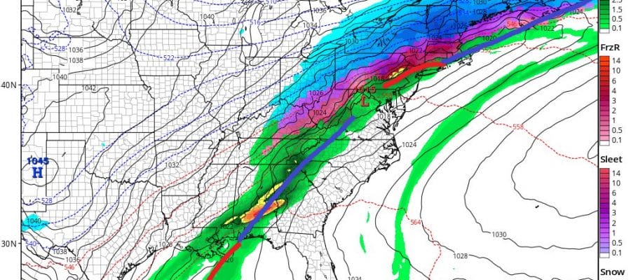
Thursday will be the warmest day though we will have clouds and ahead of a cold front. Rain that front will initially go to our north so I don’t think much happens until the front gets closer later Thursday night. This is a different type of set up. We have a slow moving cold front, a bitter cold high to the northwest that is pushing both to the east and to the south. Part of the high drops cold air into the Middle Mississippi Valley the Southern Plains and Texas and the other part builds east into New England.
This will be a massive overrunning event for areas from Texas northeastward to the lower Great Lakes and eventually the upper Ohio Valley, and then into Western Pennsylvania and Western and Northern NY. The issue for our area is timing of the front and how much precipitation is left after the front goes by.

If the ridge off the East Coast weakens faster and the developing wave on this cold front is a little slower (as the lastest GFS model run suggests) we could see rain go over to freezing rain and then snow Friday with potential for more than something minor. Other models suggest the front and the wave come through about the same time making for a change to ice and maybe a little snow later Friday and while it might make for slick conditions, it will be a bit easier to handle. It will be interesting to see if the overnight mid cycle run is on to something here. Unlike that very weak front a few weeks ago this one has a very strong overrunning signature to it with a strong warm southwest flow aloft and a bitter cold air mass to interact with to its north. Winter Storm Watches are already going up in the Middle Mississippi Valley to the Great Lakes. This could be a a more serious situation from the standpoint of ice and snow if we see the wave slower and the colder air comes in faster as the GFS is implying.
WEATHER RADAR CLICK FOR LATEST LOOP

BE SURE TO DOWNLOAD THE FREE METEOROLOGIST JOE CIOFFI WEATHER APP &
ANGRY BEN’S FREE WEATHER APP “THE ANGRY WEATHERMAN!
MANY THANKS TO TROPICAL TIDBITS & F5 WEATHER FOR THE USE OF MAPS
Please note that with regards to any severe weather, tropical storms, or hurricanes, should a storm be threatening, please consult your local National Weather Service office or your local government officials about what action you should be taking to protect life and property.


