DOWNLOAD MY NEW FREE JOESTRADAMUS WEATHER APP FOR ALL DEVICES
Warmer Air On The Way Sunday Monday Decent Weekend

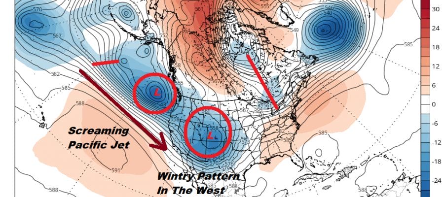
The upper air pattern is shifting around with a deep trough now digging down in the west. On the satellite picture on the lower left you can see the swirl of clouds coming into California. They have been getting heavy rains for the last 2 days. The upper pattern is actually bringing the miserable cold spring weather to the Western US for a change. That opens the door for warmer air to move into the Northeast over the weekend and into Monday and keeping shower chances to a minimum. It is a nice welcomed change to the miserable weather we have seen so far this month. We should be able to reach 80 in some places and temperatures on Monday with a west wind ahead of a cold front could climb through the 80s in many locations. It might even reach 80 degrees along the always vulnerable coastal areas as well.
SATELLITE

REGIONAL RADAR

We managed a nice day today with quiet radars that won’t be an issue into Friday morning. Most lows overnight with some passing clouds will be in the low to mid 50s in most places. Then on Friday a cold front approaches and it looks to be rather weak. This should give us clouds and some sun with the chance for passing showers during the afternoon and evening. Highs will be in the 70s to near 80 in most places and of course a bit cooler at the shore.
WEEKEND OUTLOOK LOOKS GOOD
The front will have minimal impact on our weekend weather especially on Saturday when we will see a fair amount of sunshine and temperatures in the 70s. Sunday I believe will feature a mix of sun and clouds with temperatures in the 70s to near 80. A warm front will be edging through from the next weather system to the north Sunday night with some passing showers. This then sets us up for a west wind ahead of a cold front. If the sun succeeds to break through the clouds and I believe it will, temperatures will reach the 80s just about everywhere!

There should be no issues from that cold front on Monday when it passes through in the evening. Cooler dry air follows for Tuesday and Wednesday of next week. Suddenly it seems that the weather for the most part over the next 4 or 5 days will be rather nice with just a minimal interruption from showers. When they do happen they will occur at night. This should make up somewhat for the dismal conditions of earlier this week.
MANY THANKS TO TROPICAL TIDBITS FOR THE USE OF MAPS
Please note that with regards to any tropical storms or hurricanes, should a storm be threatening, please consult your local National Weather Service office or your local government officials about what action you should be taking to protect life and property.


