Warm Weekend Autumn Air Arrives Monday
SHOP THE JOESTRADAMUS STORE
Warm Weekend Autumn Air Arrives Monday
Now that the weekend is here we can look ahead to another warm up. The shot of cool New England Eastern Canada air is beginning to move out to the east and that is allowing warmer and more humid air to come up from the south. We are also going to see clouds to the south increase overnight as we make a transition over to a warm humid air mass which will complete itself on Sunday. There isn’t much going on with respect to rain. In fact only the very bottom of the atmosphere is moisture. Above 5000 feet the atmosphere is actually very dry which explains why we are not seeing any rain as we switch to a warmer more humid air mass.
SATELLITE LOOP

REGIONAL RADAR

Saturday with lots of clouds and the chance for a shower or just some drizzle, temperatures will probably struggle a bit though they should make the low 70s in most places. Then on Sunday after some morning low clouds and dense fog we should go to some sunshine with highs reaching into the 80s. Some record highs are possible. Then a cold front moves through Sunday night with a few showers.
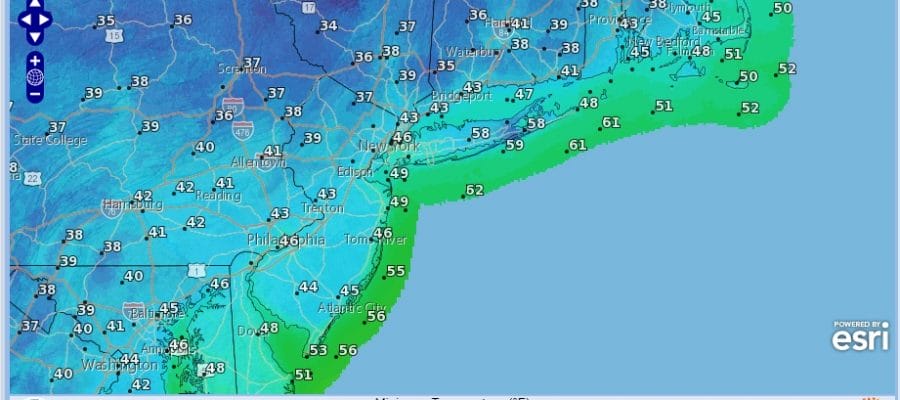
MONDAY FORECAST HIGHS

TUESDAY MORNING FORECAST LOWS

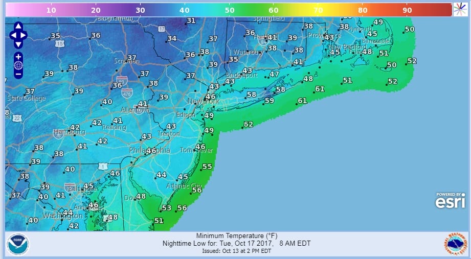
Monday & Tuesday we will see the first genuine shot of Autumn air and this will be impacting temperatures with Monday’s highs just in the low to mid 60s. We should see some sunshine and clouds. Monday night into Tuesday morning it will be quite cool with most lows in the 40s though there will be a large area of 30s just inland of the coast. Tuesday’s highs in some locations may not get out of the 50s. The cold shot then pulls out and temperatures will start to head higher again later this week. Other than any scattered showers we see Sunday night much if not all of next week could be free of any rain.
 GET JOE A CIGAR IF YOU LIKE

FiOS1 News Weather Forecast For Long Island
FiOS1 News Weather Forecast For New Jersey
FiOS1 News Weather Forecast For Hudson Valley


