
Warm Up Limited Sun Today More Sun Monday, Showers Tuesday Colder Mid Late Week
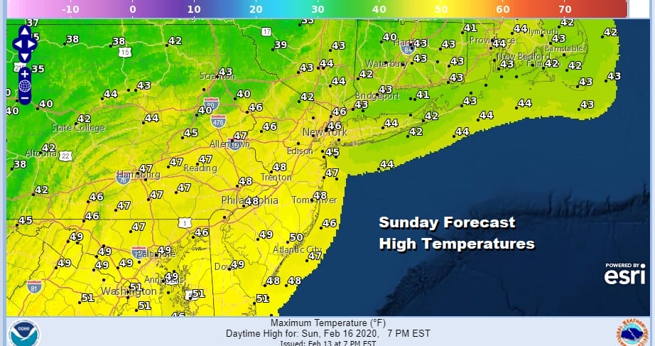
Day two of the holiday weekend is a warmer one now that the core of the arctic air has moved out almost as fast as it moved in. In fact it moved out so fast that clouds developed overnight and we will be dealing with high clouds today with breaks of limited sunshine. This should not stop the temperatures from rising up into and in some cases through the 40s. Areas to the south of NYC and Philadelphia might push the upper limits to the upper 40s to near 50 if we get enough sun in the mix.
SATELLITE

REGIONAL RADAR

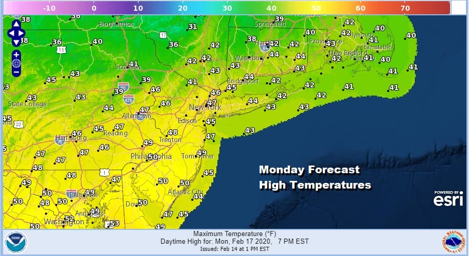
In spite of all the clouds there really isn’t much to worry about radar wise. We do have a weak cold front arriving tonight but there won’t be much with that. High pressure will build in behind it for Monday Presidents Day which clears out the cloud cover and brings us a good deal of sunshine for most of the day. Highs will be mostly in the low to mid 40s.
Tuesday brings the next round of showers as a cold front heads east and low pressure moves across the Northern Great Lakes into New England. This will not be a big rain producer. Rain arrives Tuesday morning. It might start briefly as snow or sleet well northwest of the coast. Highs will try to reach into the 50s briefly until the front passes.

This system puts down a quarter to at most a half inch of precipitation on Tuesday and then the front moves offshore. A large cold high builds in for Wednesday through Friday of next week keeping things dry. The front stalls across the Gulf States and Southeast US where a couple of waves will move along it but they aren’t going to turn northward up the coast. The flow from west to east in the upper atmosphere remains stubborn and rather fast.
Window Opens A Crack for Snow Lovers Late Month & Into Early March
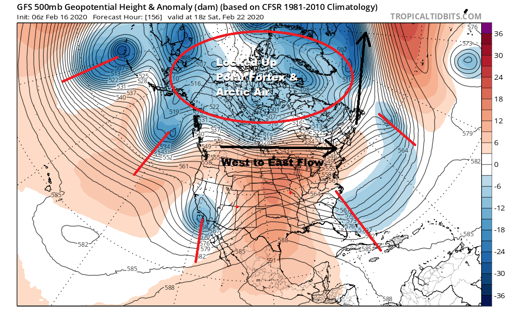
Half of February is gone with just 2 weeks left to the month. We have been locked into this pattern since early January where the Arctic Polar Vortex remains essentially locked up over the Arctic and up until the last two days (Friday and Saturday), even intrusions of cold air have been either minimal or virtually non existent. 6 to 8 weeks of a locked in weather pattern are usually about as long as they go and this one is beginning to get a little long in the tooth. Perhaps the shot of cold air we just went through is a sign of some some sort of pattern shift coming up. However for snow lovers all the time has been wasted and even if the upper air pattern does shift somewhat going into March this leaves you with little time left for a widespread snowfall.
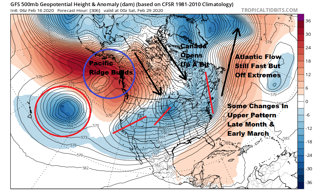
There are some changes in the flow being indicated on both the Pacific and Atlantic side as well as across Canada. The changes might be enough to create a very small window of opportunity however bear in mind that it is conceivable that even with this change, we will go through the month of March without so much as even a coating of snow in the I-95 corridor. Things would have to line up just perfectly for something to happen. The window of opportunity is opened by a crack but by only a crack and it could very easily just shut off for good. We will watch because..well there isn’t much else worth watching.
BE SURE TO DOWNLOAD THE FREE METEOROLOGIST JOE CIOFFI WEATHER APP &
ANGRY BEN’S FREE WEATHER APP “THE ANGRY WEATHERMAN!
MANY THANKS TO TROPICAL TIDBITS FOR THE USE OF MAPS
Please note that with regards to any severe weather, tropical storms, or hurricanes, should a storm be threatening, please consult your local National Weather Service office or your local government officials about what action you should be taking to protect life and property.


