Warm Spring Weather Ahead Next Week

Warm Spring Weather Ahead Next Week
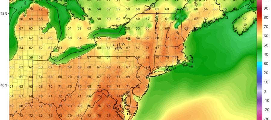
Today’s rainfall from the heavy downpours and thunderstorms this afternoon wound up to be a bit on the low side with most areas receiving 1/2 inch to an inch which was about 1/2 of what models were forecasting. Some local flooding occurred during the evening commute but all of that is done now as that heavy rain has moved north. Now we will spend the next 2 days slowly improving with lots of clouds to chew through on Friday with temperatures in the upper 40s to lower 50s on average and the risk for passing showers. Low pressure over New England and Southeast Canada will pull out Friday night and we should see some sunshine Saturday though there will be a chill in the air with highs in the 50s.
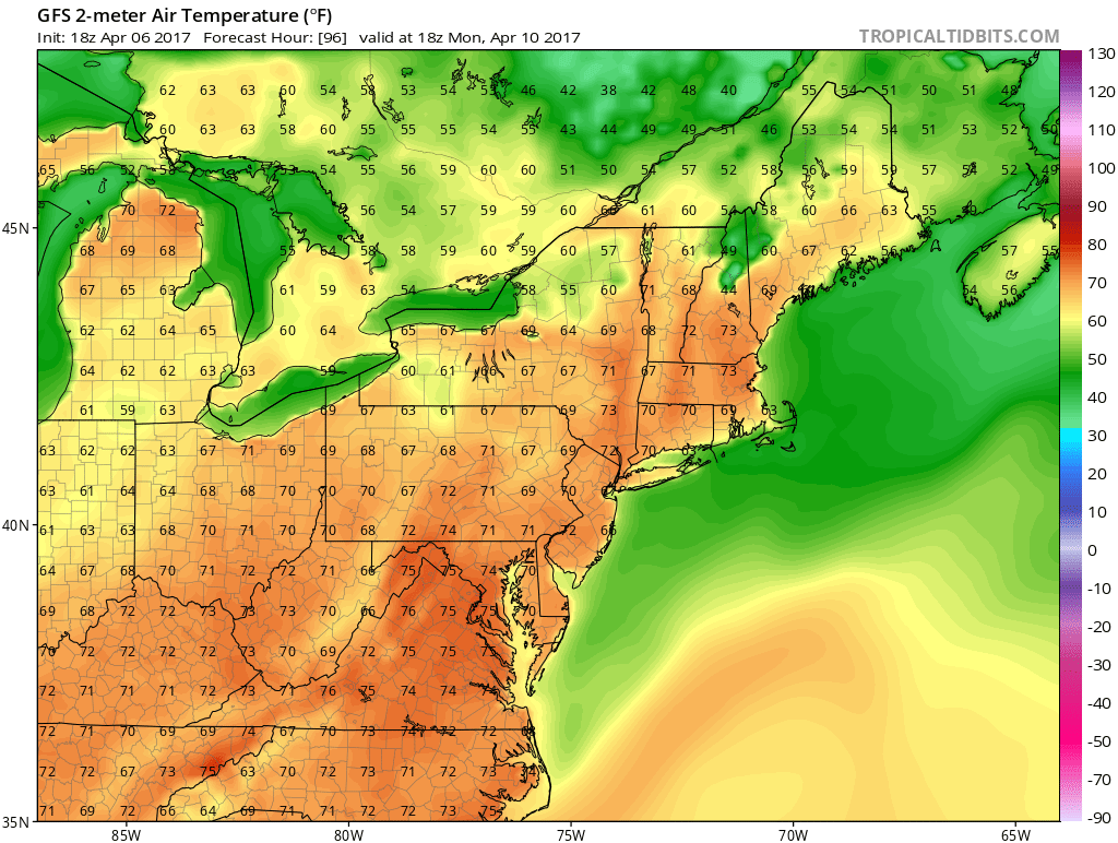
WARM SPRING WEATHER MONDAY’S FORECAST HIGHS
WARM SPRING WEATHER TUESDAY’S FORECAST HIGHS
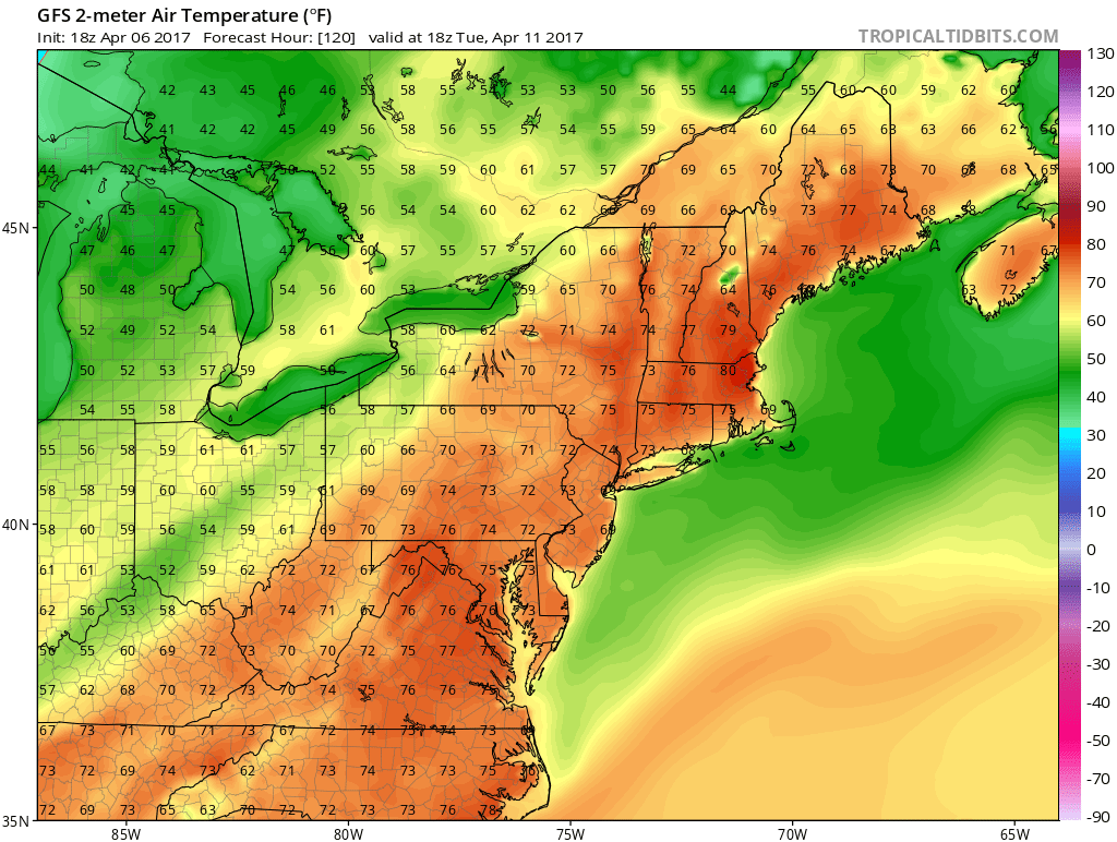
Everything is on course for a big warmup. Sunday we will see highs in the 60s with plenty of sunshine. Monday and Tuesday as the maps above show, highs will be in the 70s and 80 degrees would not be a shock at all. Even places near the coast might reach 70 as long as the sea breeze doesn’t come in too early.
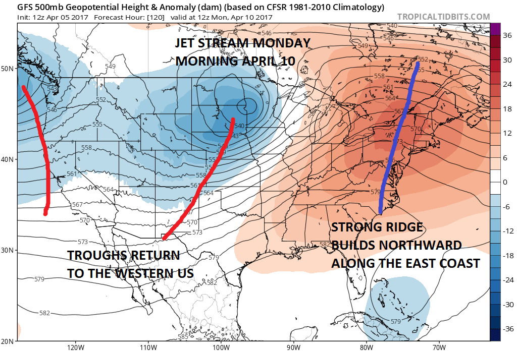
The upper air pattern shows a big ridge of high pressure aloft along the East Coast which is a big pattern flip from the last 4 weeks. The warmth breaks temporarily on Wednesday with the next weather front but the long term suggests another warm up next weekend with no big storms on the horizon.
MANY THANKS TO TROPICAL TIDBITS FOR THE WONDERFUL USE OF THE MAPS

GET JOE A CIGAR IF YOU LIKE!
LANDSCAPE COMPANIES FOR YOUR SPRING SUMMER FALL NEEDS
LONG ISLAND ROCKLAND COUNTY Connecticut

![]()

ROCKLAND COUNTY TRI STATE SNOW REMOVAL JOHNSTOWN PA


FiOS1 News Weather Forecast For Long Island
FiOS1 News Weather Forecast For New Jersey
FiOS1 News Weather Forecast For Hudson Valley
NATIONAL WEATHER SERVICE SNOW FORECASTS
LATEST JOESTRADAMUS ON THE LONG RANGE
Weather App

Don’t be without Meteorologist Joe Cioffi’s weather app. It is really a meteorologist app because you get my forecasts and my analysis and not some automated computer generated forecast based on the GFS model. This is why your app forecast changes every 6 hours. It is model driven with no human input at all. It gives you an icon, a temperature and no insight whatsoever.
It is a complete weather app to suit your forecast needs. All the weather information you need is right on your phone. Android or I-phone, use it to keep track of all the latest weather information and forecasts. This weather app is also free of advertising so you don’t have to worry about security issues with your device. An accurate forecast and no worries that your device is being compromised.
Use it in conjunction with my website and my facebook and twitter and you have complete weather coverage of all the latest weather and the long range outlook. The website has been redone and upgraded. Its easy to use and everything is archived so you can see how well Joe does or doesn’t do when it comes to forecasts and outlooks.
Just click on the google play button or the apple store button on the sidebar for my app which is on My Weather Concierge. Download the app for free. Subscribe to my forecasts on an ad free environment for just 99 cents a month.
Get my forecasts in the palm of your hand for less than the cost of a cup of Joe!
![]()
