Warm Air Moving Northward
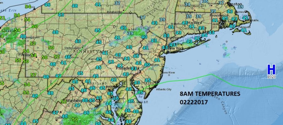
Temperatures and Radar 8am Wednesday

Warm Air Moving Northward
We see warm air getting ready to move northward as temperatures this morning are in the mild 40s for much of the area but there are concerns regarding how high the temperature gets today. First off we have clouds around and there are even a few passing showers showing up on local radars below though much of it is not reaching the ground. The other issue is the wind off the ocean from the south southeast which will at least slow the rise. The other question today is how much if any sun will be able to cut through the clouds. Inland areas in New Jersey and Pennsylvania could run to 60 in a hurry if enough sun breaks through but the cloud issue is going to be more problematic for areas long the coast and to the east.
SATELLITE LOOP

REGIONAL RADAR

Radars are showing some rain aloft streaming southeast across Eastern Pennsylvania to Long Island as of 8am. Gradually these radar echos should dry up as the day wears on. There is a steadier rain to the south in Virginia with low pressure moving across the south and heading for Florida but this rain is moving southeast and not coming in our direction.
LOCAL RADAR NEW YORK CITY

LOCAL RADAR PHILADELPHIA


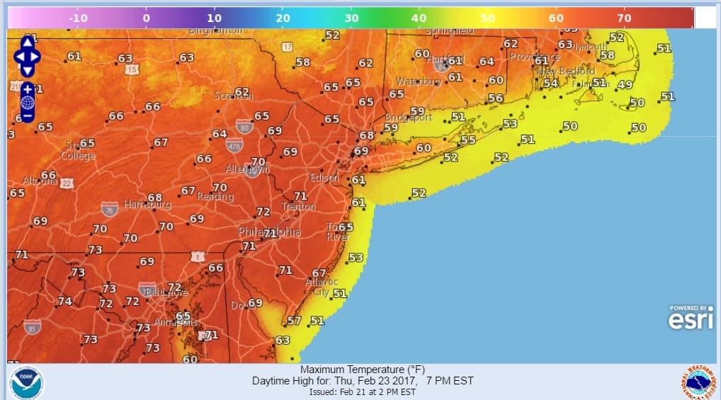
Tonight we could see some dense fog develop as warmer air really starts to stream northward over the relatively cooler marine air below. A wind shift to the west on Thursday is key to the chance for record or near record highs. Any sun will mean some 70 degree readings will appear but this will hinge on clouds and fog burning off.
WARM THURSDAY RECORD HIGHS POSSIBLE
Friday should be less warm as that ocean flow begins again and then the next big change will come Saturday with an approaching cold front. Spring patters mean the chance for thunderstorms and such will be the case when the front approaches later in the afternoon on Saturday. Dry cooler air arrives behind it on Sunday. Saturday we will be in the 60s again and Sunday we will be in the 40s.
 GET JOE A CIGAR IF YOU LIKE

SNOW REMOVAL COMPANIES FOR YOUR WINTER NEEDS
LONG ISLAND ROCKLAND COUNTY Connecticut

![]()

ROCKLAND COUNTY TRI STATE SNOW REMOVAL JOHNSTOWN PA


FiOS1 News Weather Forecast For Long Island
FiOS1 News Weather Forecast For New Jersey
FiOS1 News Weather Forecast For Hudson Valley
NATIONAL WEATHER SERVICE SNOW FORECASTS
LATEST JOESTRADAMUS ON THE LONG RANGE
Weather App

Don’t be without Meteorologist Joe Cioffi’s weather app. It is really a meteorologist app because you get my forecasts and my analysis and not some automated computer generated forecast based on the GFS model. This is why your app forecast changes every 6 hours. It is model driven with no human input at all. It gives you an icon, a temperature and no insight whatsoever.
It is a complete weather app to suit your forecast needs. All the weather information you need is right on your phone. Android or I-phone, use it to keep track of all the latest weather information and forecasts. This weather app is also free of advertising so you don’t have to worry about security issues with your device. An accurate forecast and no worries that your device is being compromised.
Use it in conjunction with my website and my facebook and twitter and you have complete weather coverage of all the latest weather and the long range outlook. The website has been redone and upgraded. Its easy to use and everything is archived so you can see how well Joe does or doesn’t do when it comes to forecasts and outlooks.
Just click on the google play button or the apple store button on the sidebar for my app which is on My Weather Concierge. Download the app for free. Subscribe to my forecasts on an ad free environment for just 99 cents a month.
Get my forecasts in the palm of your hand for less than the cost of a cup of Joe!


