
Very Cold Night Ahead Gusty Winds Dry Warmer Monday
2 Storm Systems Next Week Watching Friday

Very Cold Night Ahead Gusty Winds Dry Warmer Monday
2 Storm Systems Next Week Watching Friday
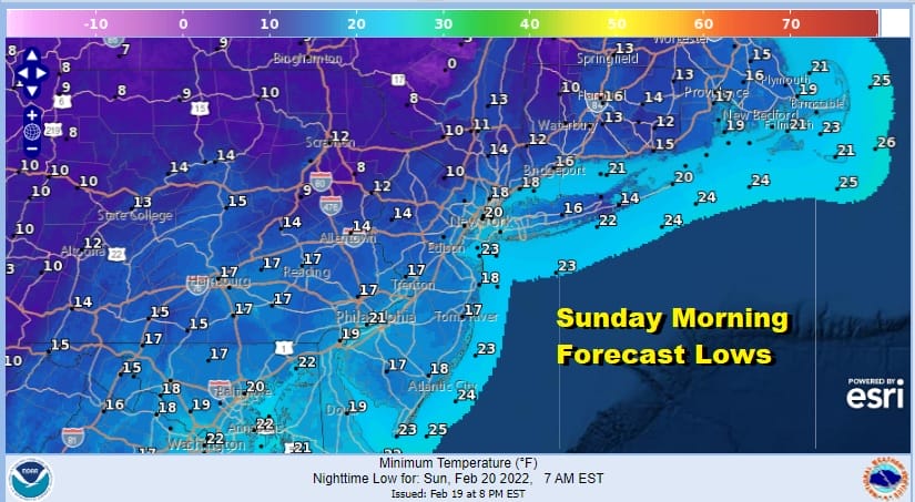
The upper trough and cold front have passed. Some of you saw some brief heavy snow squalls while others did not. Now it is on to a windy cold night under clear skies. This shot of cold air will be short lived but it will be around through Sunday. Lows by Sunday morning will be in the teens except near 20 in the warmest urban areas. Sunday with high pressure moving to the coast we will have mostly sunny skies, less wind, and most highs will be in the mid to upper 30s.
SATELLITE

WEATHER RADAR

The core of the cold air mass moves out fast and a warm up starts quickly as winds go west Sunday night. Monday morning lows will be in the mid 20s to lower 30s. That will be a nice launching pad for Monday. We should see sunshine for most of the day. Highs will reach the 50s in many locations by afternoon.

Tuesday we have the next in a series of storms coming out of the Plains. This one is similar to the system from Thursday except that it is not as strong. We will see some rain Tuesday and Tuesday night before it all ends by early Wednesday morning. Temperatures Tuesday will be in the 50s. The front passes offshore and we begin to set the table for system number 3 for later Thursday night and Friday.

This time we have changes going on in the Northeast Pacific that will allow cold air to build and spread out across Canada and also drain southward through New England into the Northern Mid Atlantic states. A developing wave on the front will move northeast and will try to go to our west however if the cold high and the new Northeast Pacific pattern are strong enough, it will hold the cold air in the east and force the low to take a more southern route. This is not a guarantee to happen as models are mixed on the strength of the wave and the high to the north. These are the variables in play for the end of next week. If the pattern is strong enough it will open the door to a snow ice rain event for Friday. If not it may be some snow or sleet at the start followed by a cold rain. There are fewer puzzle pieces this time around which in some ways makes the forecast a bit easier but it will still have its usual challenges. We will certainly talk more about this Sunday as we start to come into the short range view.
BE SURE TO DOWNLOAD THE FREE METEOROLOGIST JOE CIOFFI WEATHER APP &
ANGRY BEN’S FREE WEATHER APP “THE ANGRY WEATHERMAN!
MANY THANKS TO TROPICAL TIDBITS & F5 WEATHER FOR THE USE OF MAPS
Please note that with regards to any severe weather, tropical storms, or hurricanes, should a storm be threatening, please consult your local National Weather Service office or your local government officials about what action you should be taking to protect life and property.


