
Very Chilly Morning Sunny Saturday Clouds & Sun Sunday Rain Late Monday
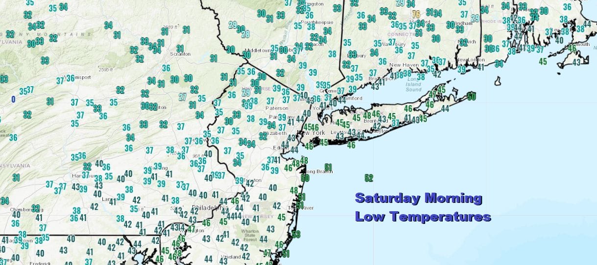
The weekend is underway and you woke up to the lowest temperatures we have seen since back last May. Some areass did visit the 32 degree mark or less in Northeastern Pennsylvania, Northwest New Jersey, parts of the Hudson Valley north of Route 84 and Northwest Connecticut. Coastal areas from Long Island south through the rest of New Jersey mostly bottomed in the upper 30s to mid 40s.
Skies are mostly clear from Maine southward into Southeastern Virginia as high pressure moves southeast to off the coast of Massachusetts later today. We should enjoy plenty of sunshine all day long There are a few coastal clouds hugging parts of the New Jersey shore and you can see the clouds that are offshore being produced by the very cool air overrunning the very warm ocean. However the onshore flow is not an issue as winds will go from the north northeast to south late today and tonight. Regional and local radars are on hiatus today and temperatures this afternoon will top in the upper 50s to lower 60s making for a very cool Autumn day perfect for apple or pumpkin picking or a bit of fishing.
SATELLITE

REGIONAL RADAR

Though tonight starts clear it will not be as cool as last night as the wind turns to the south. Also the new wind direction will bring a return flow of clouds that are now setting up to our southwest. Temperatures overnight will bottom in the 40s to lower 50s in most places.
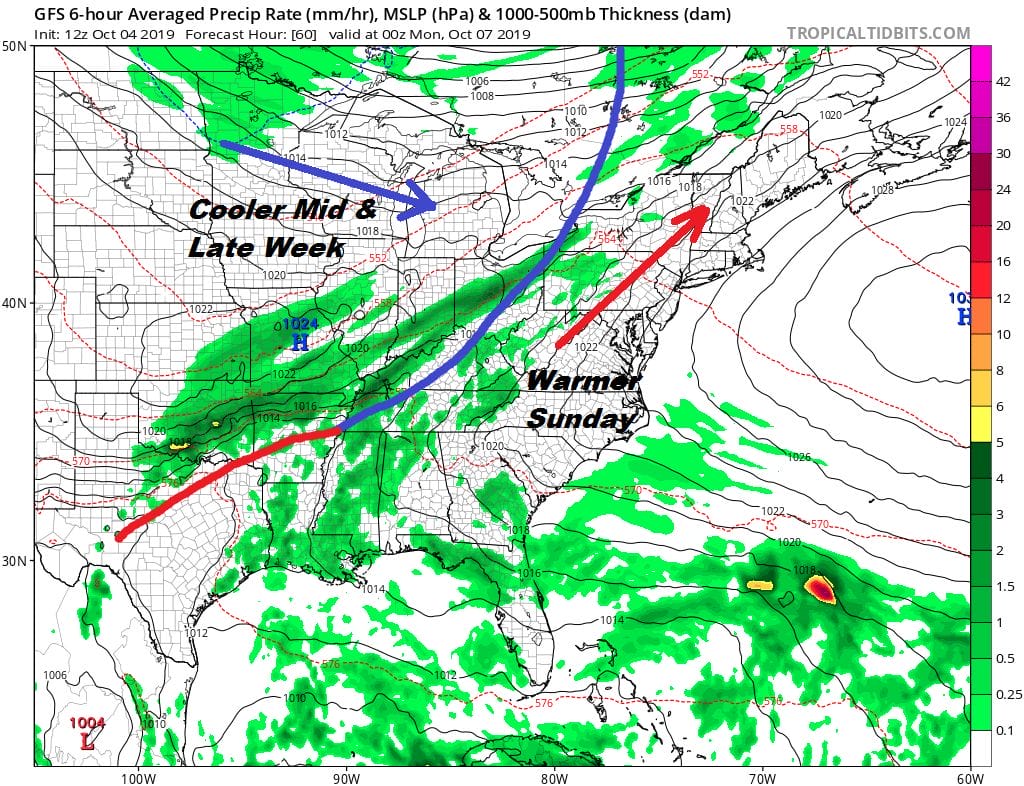
The southwest flow warms us up and we should see more in the way of clouds. There should be some breaks of sunshine in the mix. I’m leaving out the possibility of the odd sprinkle or shower and keeping the day dry. Highs will reach the upper 60s to lower 70s. The next front to the west begins its approach as it crawls eastward on Monday. It will be a cloudy and rather warm start to the week with highs reaching the mid to upper 70s and a good chance for showers developing from west to east in the afternoon and evening. This front is going to take its time getting out of the way so we could see some rain showers still lingering at the coast Tuesday morning.
IT HAS SUDDENLY GOTTEN A BIT MORE COMPLICATED FOR MIDWEEK
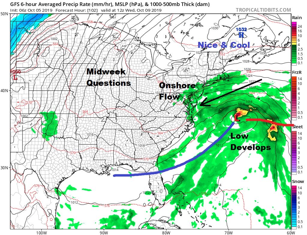
i should have known that it looked too easy to say that the weather would be nice Tuesday through Friday. The front Monday is going to stall to the south ans the next high heads into New England. It now looks likely that some kind of low is going to develop on the frontal boundary which at the very least could keep us in clouds here on Tuesday and even bring in some rain for Wednesday though right now I have a lot of questions running through my head as to how this plays out and will wait to see where this all goes later today and on Sunday. For now lets say that Tuesday will be dry, cooler and with lots of clouds around with highs in the 60s. Wednesday could be the same or perhaps rain backs in from off the ocean. If the high is a little stronger to the north and the low a bit flatter we could see improvement from north to south and the rain stays offshore. Let’s see how this evolves over the weekend.
MANY THANKS TO TROPICAL TIDBITS FOR THE USE OF MAPS
Please note that with regards to any severe weather, tropical storms, or hurricanes, should a storm be threatening, please consult your local National Weather Service office or your local government officials about what action you should be taking to protect life and property.


