Tropical Wave Heads Westward In Atlantic
Tropical Wave Heads Westward In Atlantic
With regards to the tropical wave in the Central Tropical Atlantic it continues to experience hostile conditions and though thunderstorms are flaring up a bit today, strong upper level winds and dry air to the northwest (brownish area on the water vapor loop) are limiting it. The strong upper low that just east of the Bahamas is the driver here and this wave will remain under hostile conditions for the next 2 days or so. However that is going to be changing at the end of the week and the weekend.

You can see the perspective on the loop below with the wave out in the Atlantic, clouds and showers in the Eastern Bahamas, and Tropical Storm Franklin moving into the Southwest Gulf of Mexico. The strong upper low in the Atlantic is forecast to drop southwestward into the Caribbean. Once that happens strong upper winds in the Atlantic will relax and conditions will grow more favorable for development. This will begin to happen once the Atlantic wave goes west of 60 degrees west.

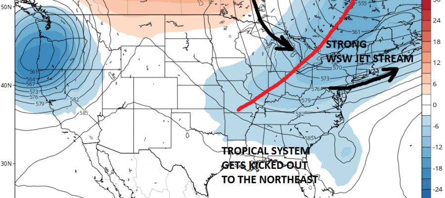
The European continues to grow more bullish on the prospects of development of this wave once it nears the Eastern Bahamas. In fact both the European and the Canadian develop this into a hurricane early next week off the Southeast coast of the United States. However before everyone gets worked up about this let me point out that the upper air winds over the Eastern United States will prevent this system from moving up the east coast. It may get close to the Southeast coast but the upper trough swinging around will pick this up and shoot it out to the northeast and out to sea.

So unless the jet stream on the models is completely different (and that doesn’t seem likely) there is no threat for a Tropical Storm along the east coast.
MANY THANKS TO TROPICAL TIDBITS FOR THE WONDERFUL USE OF THE MAPS
Weather App

Don’t be without Meteorologist Joe Cioffi’s weather app. It is really a meteorologist app because you get my forecasts and my analysis and not some automated computer generated forecast based on the GFS model. This is why your app forecast changes every 6 hours. It is model driven with no human input at all. It gives you an icon, a temperature and no insight whatsoever.
It is a complete weather app to suit your forecast needs. All the weather information you need is right on your phone. Android or I-phone, use it to keep track of all the latest weather information and forecasts. This weather app is also free of advertising so you don’t have to worry about security issues with your device. An accurate forecast and no worries that your device is being compromised.
Use it in conjunction with my website and my facebook and twitter and you have complete weather coverage of all the latest weather and the long range outlook. The website has been redone and upgraded. Its easy to use and everything is archived so you can see how well Joe does or doesn’t do when it comes to forecasts and outlooks.
Just click on the google play button or the apple store button on the sidebar for my app which is on My Weather Concierge. Download the app for free. Subscribe to my forecasts on an ad free environment for just 99 cents a month.
Get my forecasts in the palm of your hand for less than the cost of a cup of Joe!
![]()
![]()