Tropical Storm Warning West Florida

Tropical Storm Warning West Florida
Tropical Depression Forms Southern Gulf of Mexico
Tropical Storm Conditions Florida Monday
90% Chance Of Tropical Storm Development

Above is the latest satellite loop of the disturbed weather in the Northwest Caribbean Sea. If you look carefully as the dayside visible images appear, a low level center appears to have formed off the northern coast of the Yucatan Peninsula. Based on satellite the National Hurricane Center has issued its first advisory on Tropical Depression #3.
Tropical Storm Warning West Florida
...TROPICAL DEPRESSION FORMS OVER THE SOUTHERN GULF OF MEXICO...


SUMMARY OF 1000 AM CDT...1500 UTC...INFORMATION
-----------------------------------------------
LOCATION...21.9N 88.1W
ABOUT 125 MI...200 KM NW OF COZUMEL MEXICO
ABOUT 550 MI...880 KM SW OF TAMPA FLORIDA
MAXIMUM SUSTAINED WINDS...35 MPH...55 KM/H
PRESENT MOVEMENT...N OR 360 DEGREES AT 8 MPH...13 KM/H
MINIMUM CENTRAL PRESSURE...1005 MB...29.68 INCHES


WATCHES AND WARNINGS
--------------------
CHANGES WITH THIS ADVISORY:

A Tropical Storm Warning has been issued for the Gulf coast of
Florida from Indian Pass to Englewood.

SUMMARY OF WATCHES AND WARNINGS IN EFFECT:

A Tropical Storm Warning is in effect for...
* Indian Pass to Englewood

A Tropical Storm Warning means that tropical storm conditions are
expected somewhere within the warning area within 36 hours.

Interests along the coast of northeastern Florida through southern
South Carolina should monitor the progress of this system.

For storm information specific to your area, including possible
inland watches and warnings, please monitor products issued by your
local National Weather Service forecast office.


DISCUSSION AND 48-HOUR OUTLOOK
------------------------------
At 1000 AM CDT (1500 UTC), the center of Tropical Depression Three
was located near latitude 21.9 North, longitude 88.1 West. The
depression is moving toward the north near 8 mph (13 km/h).  A
north-northeastward motion at a faster forward speed is expected
later today through Monday. On this track, the center of the
depression is forecast to approach the coast of the Florida Big Bend
area Monday afternoon.

Maximum sustained winds are near 35 mph (55 km/h) with higher gusts.
Some strengthening is forecast, and the depression is expected to
become a tropical storm before reaching the coast of Florida.
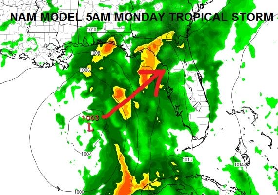
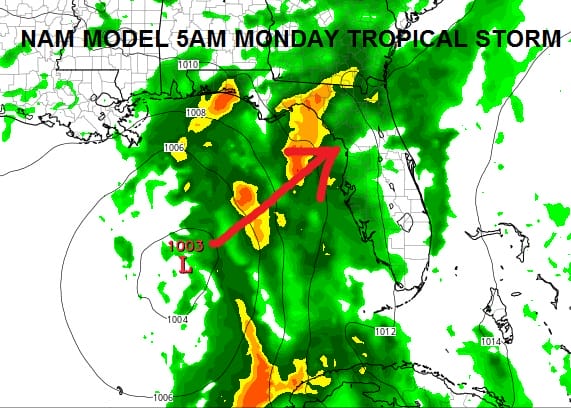
All model guidance seems to point to the northwest coast of Florida as the target between Tampa and Panama City. The NAM model is the furthest west with its course while the GFS and Euro Models overnight were further east which makes more sense.
Tropical Storm Warning West Florida
We would expect that the tropical depression will become a tropical storm later today or tonight as it moves northward and away from the land mass of the Yucatan Peninsula.
LATEST VIDEO ANALYSIS ON SEVERE WEATHER AND TROPICAL STORM THREAT FOR FLORIDA
JOESTRADAMUS HURRICANE SEASON GUEST FORECAST
FiOS1 News Weather Forecast For Long Island
FiOS1 News Weather Forecast For New Jersey
FiOS1 News Weather Forecast For Hudson Valley
NATIONAL WEATHER SERVICE SNOW FORECASTS
LATEST JOESTRADAMUS ON THE LONG RANGE
Weather App

Don’t be without Meteorologist Joe Cioffi’s weather app. It is really a meteorologist app because you get my forecasts and my analysis and not some automated computer generated forecast based on the GFS model. This is why your app forecast changes every 6 hours. It is model driven with no human input at all. It gives you an icon, a temperature and no insight whatsoever.
It is a complete weather app to suit your forecast needs. All the weather information you need is right on your phone. Android or I-phone, use it to keep track of all the latest weather information and forecasts. This weather app is also free of advertising so you don’t have to worry about security issues with your device. An accurate forecast and no worries that your device is being compromised.
Use it in conjunction with my website and my facebook and twitter and you have complete weather coverage of all the latest weather and the long range outlook. The website has been redone and upgraded. Its easy to use and everything is archived so you can see how well Joe does or doesn’t do when it comes to forecasts and outlooks.
Just click on the google play button or the apple store button on the sidebar for my app which is on My Weather Concierge. Download the app for free. Subscribe to my forecasts on an ad free environment for just 99 cents a month.
Get my forecasts in the palm of your hand for less than the cost of a cup of Joe!
![]()
![]()

MENTION JOE CIOFFI AND GET A 5% DISCOUNT