Thunderstorms Gearing Up West

Thunderstorms Gearing Up West Some Strong to Severe Thunderstorms Possible Late This Afternoon and Evening
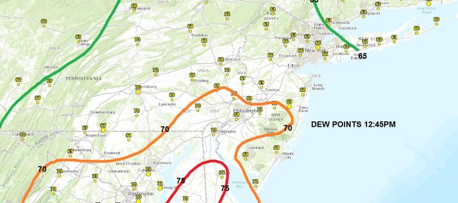
The warm front is moving through the New York City Long Island area at the moment and the cold front is sweeping across Western Pennsylvania. The key to how far north the severe weather gets will be the dew points which will show us just how saturated the air is this afternoon. Anything above 65 would be prime for thunderstorms and 70 is a good indicator of severe weather.
Thunderstorms Gearing Up West Latest Dew Points
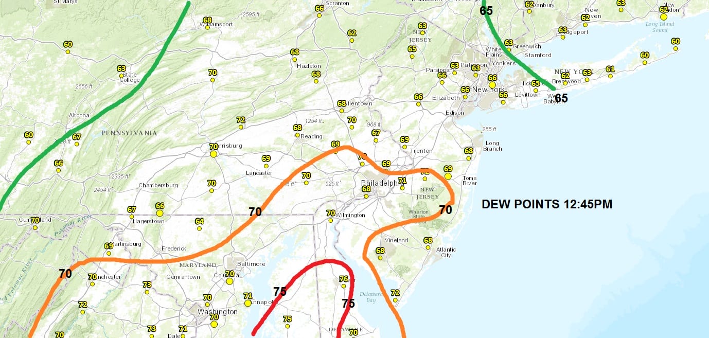
The 70 plus dew points are in Southern New Jersey as of lunch time with some 75 plus dew points Eastern Maryland. Now we wait to see how much daytime heating occurs. The satellite loop shows clouds breaking up in the southern half of New Jersey south and west which should give a good boost to temperatures.
Thunderstorms Gearing Up West Satellite Loop

Thunderstorms Gearing Up West Regional Radar

Thunderstorms Gearing Up West Local Radars


From here on in we just watch and wait with regards to the radar. You can check the local conditions here as of 12 noon.
CITY           SKY/WX    TMP DP  RH WIND       PRES   REMARKS
CENTRAL PARK   CLOUDY    67  65  93 S7        29.78F FOG
LAGUARDIA APRT DRZL/FOG  66  64  94 VRB3      29.76F VSB 1
KENNEDY INTL   CLOUDY    69  66  90 SE16      29.77F
NEWARK/LIBERTY DRZL/FOG  67  66  97 E7        29.75F VSB 3/4
BRNX BOT. GARD   N/A     64  63  94 S5        29.78F
TETERBORO      CLOUDY    66  62  87 E5        29.75F FOG
$$

NYZ177-179-078>081-051800-
LONG ISLAND NEW YORK

CITY           SKY/WX    TMP DP  RH WIND       PRES   REMARKS
FARMINGDALE    LGT RAIN  67  66  97 SE14G24   29.77F FOG
ISLIP          HVY RAIN  65  63  93 SE14      29.78F VSB 1
SHIRLEY        LGT RAIN  65  63  93 SE9G20    29.80F
RIVERHEAD        N/A     68  64  88 SW10      29.80F
WESTHAMPTON    CLOUDY    65  61  87 SE13G20   29.83F
EAST HAMPTON   CLOUDY    64  60  88 SE9       29.84F
MONTAUK POINT    N/A     63  59  87 E8        29.87F
$$

NYZ052-065-067-051800-
HUDSON VALLEY

CITY           SKY/WX    TMP DP  RH WIND       PRES   REMARKS
WHITE PLAINS   LGT RAIN  64  63  96 E9        29.78F FOG
NEWBURGH       CLOUDY    64  64 100 SE14      29.77F FOG
MONTGOMERY     LGT RAIN  67  65  93 SW3       29.75F FOG
POUGHKEEPSIE   LGT RAIN  68  63  84 S5        29.76F
ALBANY         CLOUDY    69  58  67 S13       29.72F
$$

NJZ001-105-106-008-010-013-015-019>022-104-051800-
NEW JERSEY

CITY           SKY/WX    TMP DP  RH WIND       PRES   REMARKS
NEWARK/LIBERTY DRZL/FOG  67  66  97 E7        29.75F VSB 3/4
TETERBORO      CLOUDY    66  62  87 E5        29.75F FOG
CALDWELL       CLOUDY    67  65  93 VRB5      29.76F FOG
MORRISTOWN     CLOUDY    66  66 100 S7        29.77F FOG
SOMERVILLE     CLOUDY    71  67  87 CALM      29.72F FOG
SUSSEX         CLOUDY    67  63  87 VRB3      29.74F
ANDOVER          N/A     67  64  90 CALM      29.75F
TRENTON        CLOUDY    77  69  76 SW10      29.72F
MILLVILLE      CLOUDY    78  68  71 S8        29.75F
ATLANTIC CITY  CLOUDY    79  69  71 S13G22    29.75F
WRIGHTSTOWN    CLOUDY    81  70  69 SW12G17   29.70F
TOMS RIVER     PTSUNNY   82  68  61 S13G20    29.73F
BELMAR         CLOUDY    71  69  93 SE9       29.75F
$$

PAZ047>061-062-071-051800-
EASTERN PENNSYLVANIA

CITY           SKY/WX    TMP DP  RH WIND       PRES   REMARKS
PHILADELPHIA   CLOUDY    80  68  66 S12       29.72F
ALLENTOWN      CLOUDY    72  67  84 SE7       29.72F
SCRANTON       CLOUDY    73  66  78 S7        29.69F
$$

CTZ002-004>006-009-010-012-RIZ004-006-007-MAZ004-011-015-051800-
SOUTHERN NEW ENGLAND
 IN CT

CITY           SKY/WX    TMP DP  RH WIND       PRES   REMARKS
BRADLEY INTL   CLOUDY    69  60  73 SE15      29.81F
HARTFORD       CLOUDY    72  61  68 SE12G20   29.82F
DANBURY        RAIN      65  61  87 VRB7      29.80F FOG
WTRBRY/OXFORD  LGT RAIN  64  59  82 SE12G18   29.83F FOG
BRIDGEPORT     LGT RAIN  67  64  90 E9        29.79F
MERIDEN        CLOUDY    69  62  78 SE7       29.82F
NEW HAVEN      CLOUDY    65  62  90 E12       29.81F
CHESTER        CLOUDY    63  63 100 SE8       29.84F FOG
GROTON         CLOUDY    62  61  96 E14       29.85F
WILLIMANTIC    CLOUDY    69  61  75 S7        29.85F

 IN RI
LATEST WEATHER VIDEO ANALYSIS ON SEVERE WEATHER AND TROPICAL STORM IN THE GULF OF MEXICO
JOESTRADAMUS HURRICANE SEASON GUEST FORECAST
FiOS1 News Weather Forecast For Long Island
FiOS1 News Weather Forecast For New Jersey
FiOS1 News Weather Forecast For Hudson Valley
NATIONAL WEATHER SERVICE SNOW FORECASTS
LATEST JOESTRADAMUS ON THE LONG RANGE
Weather App

Don’t be without Meteorologist Joe Cioffi’s weather app. It is really a meteorologist app because you get my forecasts and my analysis and not some automated computer generated forecast based on the GFS model. This is why your app forecast changes every 6 hours. It is model driven with no human input at all. It gives you an icon, a temperature and no insight whatsoever.
It is a complete weather app to suit your forecast needs. All the weather information you need is right on your phone. Android or I-phone, use it to keep track of all the latest weather information and forecasts. This weather app is also free of advertising so you don’t have to worry about security issues with your device. An accurate forecast and no worries that your device is being compromised.
Use it in conjunction with my website and my facebook and twitter and you have complete weather coverage of all the latest weather and the long range outlook. The website has been redone and upgraded. Its easy to use and everything is archived so you can see how well Joe does or doesn’t do when it comes to forecasts and outlooks.
Just click on the google play button or the apple store button on the sidebar for my app which is on My Weather Concierge. Download the app for free. Subscribe to my forecasts on an ad free environment for just 99 cents a month.
Get my forecasts in the palm of your hand for less than the cost of a cup of Joe!
![]()
![]()

MENTION JOE CIOFFI AND GET A 5% DISCOUNT


