Severe Thunderstorm Risk Continues
The warm front has moved through and now we sit and wait for the cold front front to swing by tonight. The Storm Prediction Center of the National Weather Service has adjusted the risk area to add much of upstate Central New York. Enhanced risk reaches New York City and covers much of New Jersey, Eastern Pennsylvania southward through Maryland, Delaware, Virginia, and North Carolina.
Severe Thunderstorm Risk Continues
Storm Prediction Center Outlook

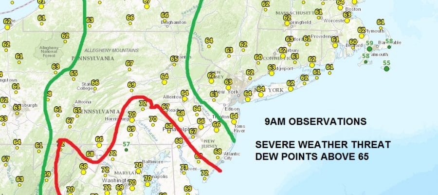
How extensive the severe weather threat is will depend on many factors especially along coast. One of the things we look at is the dew points. I like to look at where the dew points are above 65 and especially where the dew points are above 70. These high numbers reflect just how saturated the atmosphere is with rich tropical air.
Severe Thunderstorm Risk Continues
Dew Points 9AM
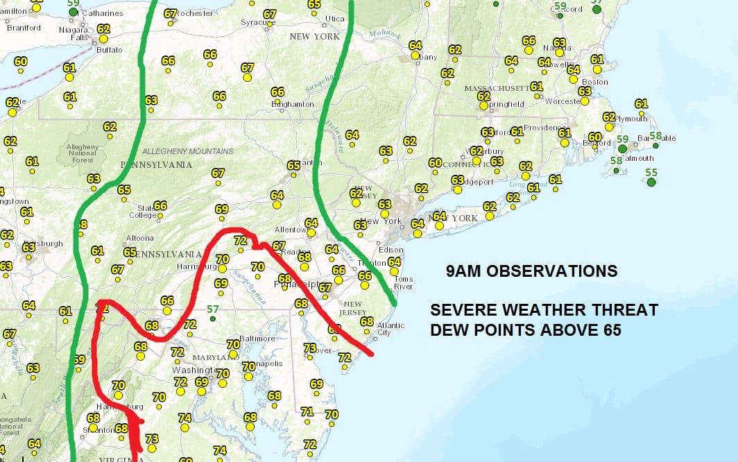
As of 9am the areas inside the green area and particularly inside the red area are prime for severe thunderstorms. Northern New Jersey northeastward into Southern New England dew points are in the lower 60s and we will have to see how high those dew points get this afternoon.
Also key to this will be if we break out into sunshine for awhile today and add to the daytime heating. There is plenty of time for that to occur before thunderstorms get here this evening across the area.
Severe Thunderstorm Risk Continues
Radar Loops


You can see from the radars that we are in a bit of gap area for the moment and not much other than passing showers are going to occur from now until mid afternoon. We will of course keep you posted with developments as we go through the day. In the meantime you can at least enjoy some dry time before any thunderstorms occur. Again nothing of consequence should happen until late afternoon/evening in Eastern Pennsylvania/Western New Jersey Southwestward into Washington DC Baltimore area..and later this evening for New York City Long Island and Southern New England.
SUNDAY VIDEO ANALYSIS SEVERE WEATHER
& TROPICAL STORM THREAT FOR FLORIDA
JOESTRADAMUS HURRICANE SEASON GUEST FORECAST

MENTION JOE CIOFFI AND GET A 5% DISCOUNT
FiOS1 News Weather Forecast For Long Island
FiOS1 News Weather Forecast For New Jersey
FiOS1 News Weather Forecast For Hudson Valley
NATIONAL WEATHER SERVICE SNOW FORECASTS
LATEST JOESTRADAMUS ON THE LONG RANGE
Weather App

Don’t be without Meteorologist Joe Cioffi’s weather app. It is really a meteorologist app because you get my forecasts and my analysis and not some automated computer generated forecast based on the GFS model. This is why your app forecast changes every 6 hours. It is model driven with no human input at all. It gives you an icon, a temperature and no insight whatsoever.
It is a complete weather app to suit your forecast needs. All the weather information you need is right on your phone. Android or I-phone, use it to keep track of all the latest weather information and forecasts. This weather app is also free of advertising so you don’t have to worry about security issues with your device. An accurate forecast and no worries that your device is being compromised.
Use it in conjunction with my website and my facebook and twitter and you have complete weather coverage of all the latest weather and the long range outlook. The website has been redone and upgraded. Its easy to use and everything is archived so you can see how well Joe does or doesn’t do when it comes to forecasts and outlooks.
Just click on the google play button or the apple store button on the sidebar for my app which is on My Weather Concierge. Download the app for free. Subscribe to my forecasts on an ad free environment for just 99 cents a month.
Get my forecasts in the palm of your hand for less than the cost of a cup of Joe!
![]()


