Tropical Storm Sally Forms Headed To Central Gulf Coast Tuesday
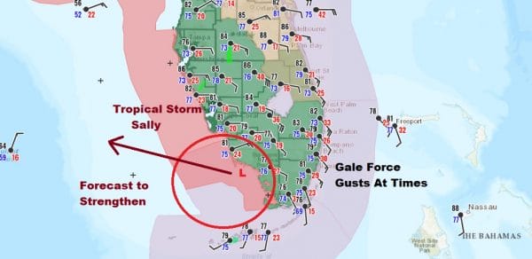
Tropical Storm Sally has formed from Tropical Depression 19 as the center emerges off the coast of Southwest Florida. Surface reports show gusts to gale force along the Florida east cast and satellite and radar images show that the system continues to organize. Once the circulation completely clears the Florida coast steady strengthening will get underway and Sally will likely become a hurricane. Conditions aloft are favorable and Gulf of Mexico water temperatures are in the mid to upper 80s.
Winds along the east coast of Florida particularly in Southeast Florida are all southeast or south-southeast while the Florida Keys all have southwest winds and the bouy out in the open Gulf Waters has a north northeast wind so clearly we have a closed circulation here. Sally is located 35 miles south southeast of Naples so technically the center is still partially over land but barely.
SATELLITE
REGIONAL RADAR
Bands of showers cover the Florida Peninsula with the core rain from Sally over Southern Florida. The counter clockwise circulation is obvious on the radar with quite a bit of rain falling in South Florida.
2PM LOCATION…25.6N 81.6W
ABOUT 35 MI…60 KM SSE OF NAPLES FLORIDA
MAXIMUM SUSTAINED WINDS…40 MPH…65 KM/H
PRESENT MOVEMENT…W OR 270 DEGREES AT 7 MPH…11 KM/H
MINIMUM CENTRAL PRESSURE…1004 MB…29.65 INCHES
LOCAL RADAR MIAMI
LOCAL RADAR PHILADELPHIA

Once out in the Gulf of Mexico if strengthen begins to occur at a fast rate, it increases the chances of this becoming a major hurricane before landfall sometime Tuesday morning. Louisiana may be in line for this again but this time it will be Southeast Louisiana vs the Southwest. This could put also the Mississippi and Alabama Gulf coast at risk as well.
Virtually all the intensity models take this to at least a category 1 hurricane and 1 so far takes it to a category 3. Hurricane model forecasts have gotten wider on possible tracks given the weak flow across the Northern Gulf of Mexico.
The range of possible tracks increases the uncertainty here with the National Hurricane Center forecast basically splitting the difference and take the middle of the road forecast.
BE SURE TO DOWNLOAD THE FREE METEOROLOGIST JOE CIOFFI WEATHER APP &
ANGRY BEN’S FREE WEATHER APP “THE ANGRY WEATHERMAN!
MANY THANKS TO TROPICAL TIDBITS FOR THE USE OF MAPS
Please note that with regards to any severe weather, tropical storms, or hurricanes, should a storm be threatening, please consult your local National Weather Service office or your local government officials about what action you should be taking to protect life and property.


