
Tropical Storm Outlook Next 5 Days
Tropical Storm Outlook Next 5 Days
No Tropical Storms Through The Weekend
2 Systems Being Watched

Looking around the tropics we see two tropical waves that call attention. Both are not going to develop anytime soon and the one in the Eastern Atlantic probably has the better chance of developing into a tropical depression or tropical storm later next week. Satellite shows the two waves. The on that is east northeast of the Leeward Islands is likely to move west northwest. Conditions do not appear favorable for rapid development so we will watch it as it gets north of the islands. None of the global models do much with this system.
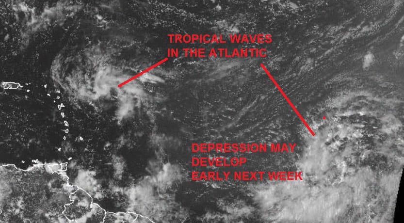
The second wave stands a better chance as all the models seem to spin this up to some degree though the European keeps it weak on this particular run. Even if something were to develop from this the upper air pattern across the Atlantic suggests it would be an ocean storm and follow a path similar to Gaston a few weeks ago.

The European model today shows what it has been showing for awhile and that is a weakness develops in the Atlantic ridge around or just east of 60 degrees west. This opens an alley way for any Eastern Atlantic storm to make a quick exit. On the other hand that trough eventually does lift out and the ridge rebuilds. If this system stays weak and responds more to the low level flow, there is always the chance it could bypass this weakness and get further west. All of this is purely speculative at this point. At least we have no tropical storms around as we go into the next to last weekend of summer.
FiOS1 News Weather Forecast For Long Island
FiOS1 News Weather Forecast For New Jersey
FiOS1 News Weather Forecast For Hudson Valley
NATIONAL WEATHER SERVICE SNOW FORECASTS
LATEST JOESTRADAMUS ON THE LONG RANGE
Weather App

Don’t be without Meteorologist Joe Cioffi’s weather app. It is really a meteorologist app because you get my forecasts and my analysis and not some automated computer generated forecast based on the GFS model. This is why your app forecast changes every 6 hours. It is model driven with no human input at all. It gives you an icon, a temperature and no insight whatsoever.
It is a complete weather app to suit your forecast needs. All the weather information you need is right on your phone. Android or I-phone, use it to keep track of all the latest weather information and forecasts. This weather app is also free of advertising so you don’t have to worry about security issues with your device. An accurate forecast and no worries that your device is being compromised.
Use it in conjunction with my website and my facebook and twitter and you have complete weather coverage of all the latest weather and the long range outlook. The website has been redone and upgraded. Its easy to use and everything is archived so you can see how well Joe does or doesn’t do when it comes to forecasts and outlooks.
Just click on the google play button or the apple store button on the sidebar for my app which is on My Weather Concierge. Download the app for free. Subscribe to my forecasts on an ad free environment for just 99 cents a month.
Get my forecasts in the palm of your hand for less than the cost of a cup of Joe!
![]()
![]()