HOT HUMID WEATHER THUNDERSTORMS
HOT HUMID WEATHER THUNDERSTORMS
It is a very warm muggy late summer afternoon with temperatures responding to sunshine and a southwest flow. The usual heat advisories are up in the usual suspect areas like New York City and Philadelphia. Temperatures are generally in the upper 80s to middle 90s in most places except right along the coast where the south wind is keeping things in the cooler upper 70s to middle 80s.
CITY           SKY/WX    TMP DP  RH WIND       PRES   REMARKS
Central Park   SUNNY     88  69  53 MISG      29.88F HX  92
LaGuardia APRT PTSUNNY   87  69  54 S13       29.85F HX  91
Kennedy INTL   PTSUNNY   80  68  66 S13       29.88F
Newark/Liberty PTSUNNY   88  70  55 SE9       29.84F HX  93
Bronx Bot Gard   N/A     86  68  54 S6        29.87F
Wall St Helipt CLEAR     88  72  58 S6        29.86F HX  94
Teterboro      MOSUNNY   89  68  49 SW9       29.83F HX  93
$$

NYZ177-179-078>081-082000-
LONG ISLAND NEW YORK

CITY           SKY/WX    TMP DP  RH WIND       PRES   REMARKS
Farmingdale    SUNNY     83  69  62 SW13      29.87F
MacArthur/ISP  PTSUNNY   82  70  66 SW10      29.86F
Shirley        SUNNY     79  70  74 S12       29.87
Riverhead      NOT AVBL
Westhampton    SUNNY     79  68  69 SW13      29.89F
Southampton      N/A     77  72  83 SW8       29.83F
Bridgehampton  NOT AVBL
East Hampton   FAIR      77  70  78 S10       29.86F
Montauk          N/A     77  70  79 S7        29.88F
$$

NYZ052-065-067-082000-
HUDSON VALLEY

CITY           SKY/WX    TMP DP  RH WIND       PRES   REMARKS
White Plains   MOSUNNY   87  68  52 VRB5      29.85F HX  90
Newburgh       MOSUNNY   88  73  62 W8        29.85F HX  96
Montgomery     PTSUNNY   90  73  57 SW13      29.82F HX  98
Poughkeepsie   MOSUNNY   87  70  56 VRB5      29.81F HX  92
Albany         PTSUNNY   87  68  52 S9        29.79F HX  90
$$

NJZ001-105-106-008-010-013-015-019>022-104-082000-
NEW JERSEY

CITY           SKY/WX    TMP DP  RH WIND       PRES   REMARKS
Newark/Liberty PTSUNNY   88  70  55 SE9       29.84F HX  93
Teterboro      MOSUNNY   89  68  49 SW9       29.83F HX  93
Caldwell       MOSUNNY   90  71  53 VRB7      29.84F HX  96
Morristown     MOSUNNY   90  72  55 W9G18     29.85F HX  96
Somerville     MOSUNNY   93  71  48 VRB6      29.83F HX 100
Linden         FAIR      92  68  45 W13G18    29.86F HX  96
Sussex         MOSUNNY   89  73  59 VRB7      29.85F HX  97
Abdover          N/A     87  71  58 SW5       29.86F HX  93
Trenton        MOSUNNY   94  70  45 NW8G16    29.85F HX 100
Millville      MOSUNNY   91  76  61 W12       29.89F HX 103
Atlantic City  CLOUDY    86  73  65 S8        29.88F HX  93
Wrightstown    SUNNY     92  72  51 VRB3      29.83F HX 100
Toms River     MOSUNNY   88  74  63 S8        29.87F HX  96
Belmar         SUNNY     84  72  67 S8        29.8

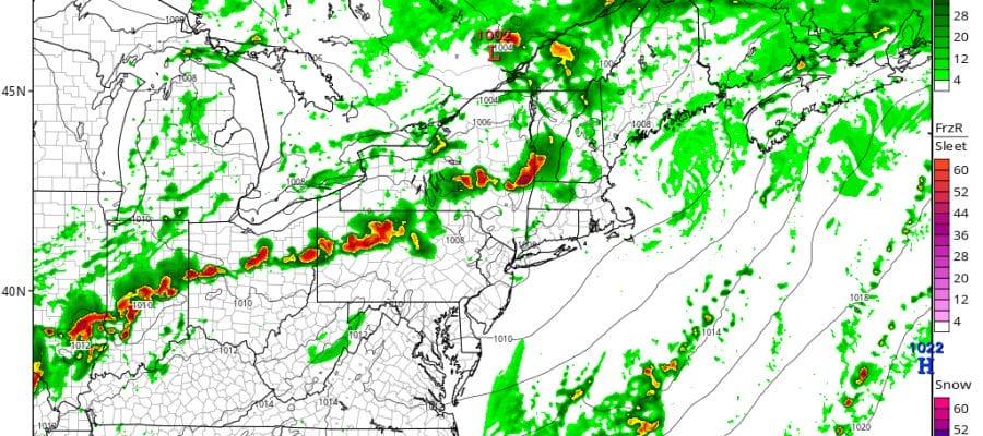
Radar shows a developing line of thunderstorms in Western New York moving eastward. The question always seems to be whether these storms will hold together or not. Local radars don’t seem to show anything at the moment and things should be fine as the evening rush hour gets underway.


The short range models like the NAM and the HRRR show most of these storms fall apart long before they get here which has been the signature of this entire summer so I can’t see why it would be any different this time around.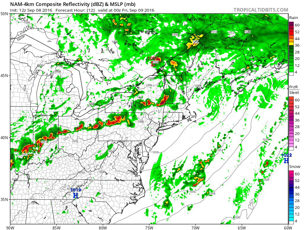
HOT HUMID WEATHER FRIDAY
More of the same is in store for Friday which looks to be hot and humid with highs in the upper 80s to middle 90s. I suppose there is the chance for an isolated shower or thunderstorm. Friday night a warm front sets up just to our south and moves northward for Saturday. There could be a few downpours late Friday night into Saturday before we go into another very warm to hot humid weather day with highs in the mid 80s in areas north and east of New York City to low 90s south and west into Southeastern Pennsylvania. A stronger front pushes through early Sunday morning and there could be a shower or thunderstorm with that before it turns less humid and starts to cool off beginning Sunday and lasting into Tuesday of next week. No big storms are on the horizon; no tropical storms to worry about at the moment.
FiOS1 News Weather Forecast For Long Island
FiOS1 News Weather Forecast For New Jersey
FiOS1 News Weather Forecast For Hudson Valley
NATIONAL WEATHER SERVICE SNOW FORECASTS
LATEST JOESTRADAMUS ON THE LONG RANGE
Weather App

Don’t be without Meteorologist Joe Cioffi’s weather app. It is really a meteorologist app because you get my forecasts and my analysis and not some automated computer generated forecast based on the GFS model. This is why your app forecast changes every 6 hours. It is model driven with no human input at all. It gives you an icon, a temperature and no insight whatsoever.
It is a complete weather app to suit your forecast needs. All the weather information you need is right on your phone. Android or I-phone, use it to keep track of all the latest weather information and forecasts. This weather app is also free of advertising so you don’t have to worry about security issues with your device. An accurate forecast and no worries that your device is being compromised.
Use it in conjunction with my website and my facebook and twitter and you have complete weather coverage of all the latest weather and the long range outlook. The website has been redone and upgraded. Its easy to use and everything is archived so you can see how well Joe does or doesn’t do when it comes to forecasts and outlooks.
Just click on the google play button or the apple store button on the sidebar for my app which is on My Weather Concierge. Download the app for free. Subscribe to my forecasts on an ad free environment for just 99 cents a month.
Get my forecasts in the palm of your hand for less than the cost of a cup of Joe!

MENTION JOE CIOFFI AND GET A 5% DISCOUNT


