TROPICAL STORM MATTHEW FORMS WINDS 60 MPH
TROPICAL STORM MATTHEW WINDS 60 MPH HEADING WEST
FORECAST TO STRENGTHEN TO A HURRICANE
The signature of Tropical Storm Matthew is very impressive and it continues to become better organized. The Air Force plane found flight level winds over 70 knots already so this system shows every indication of strengthening into a hurricane over the next few days. Wind shear conditions over the Eastern Caribbean have relaxed. The center appears to be moving westward and little change in that motion is expect for the next few days. Models continue to show the sharp northward turn in about 3 or 4 days so we will see where this all takes us.


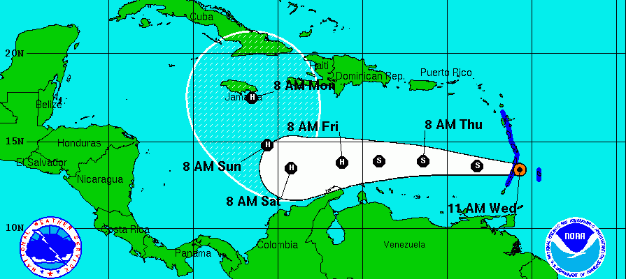
...TROPICAL STORM MATTHEW FORMS IN THE WINDWARD ISLANDS...


SUMMARY OF 1100 AM AST...1500 UTC...INFORMATION
-----------------------------------------------
LOCATION...13.4N 60.7W
ABOUT 35 MI...55 KM SE OF ST. LUCIA
ABOUT 35 MI...55 KM ENE OF ST. VINCENT
MAXIMUM SUSTAINED WINDS...60 MPH...95 KM/H
PRESENT MOVEMENT...W OR 275 DEGREES AT 21 MPH...33 KM/H
MINIMUM CENTRAL PRESSURE...1008 MB...29.77 INCHES


WATCHES AND WARNINGS
--------------------
CHANGES WITH THIS ADVISORY:

A Tropical Storm Warning is in effect for the French Islands of
Guadeloupe and Martinique.

The government of Barbados has issued a Tropical Storm Warning for
Barbados, Dominica, and St. Vincent and the Grenadine Islands.

The government of St. Lucia has issued a Tropical Storm Warning for
St. Lucia.


SUMMARY OF WATCHES AND WARNINGS IN EFFECT:

A Tropical Storm Warning is in effect for...
* Guadeloupe and Martinique
* St. Lucia
* Dominica, Barbados, St. Vincent, and the Grenadine Islands

Interests in Bonaire, Curacao, Aruba, and elsewhere in the Lesser
Antilles should monitor the progress of Matthew.

For storm information specific to your area, please monitor
products issued by your national meteorological service.


DISCUSSION AND 48-HOUR OUTLOOK
------------------------------
At 1100 AM AST (1500 UTC), the center of Tropical Storm Matthew was
located near latitude 13.4 North, longitude 60.7 West. Matthew is
moving toward the west near 21 mph (33 km/h). A westward motion with
some decrease in forward speed is expected during the next couple of
days.  On the forecast track, the center of Matthew will move
through the Windward Islands during the next couple of hours, and
move over the eastern Caribbean Sea through Friday.

Reports from an Air Force hurricane hunter aircraft indicate
that maximum sustained winds are near 60 mph (95 km/h) with higher
gusts.  Gradual strengthening is forecast during the next couple of
days, and Matthew could become a hurricane by Friday.

Tropical-storm-force winds extend outward up to 205 miles (335 km)
primarily to the notheast of the center.

The estimated minimum central pressure is 1008 mb (29.77 inches).


HAZARDS AFFECTING LAND
----------------------
WIND:  Tropical storm conditions are expected to spread over
the southern Leeward Islands and northern Windward Islands witin
the next few hours and continue into this evening.

RAINFALL:  Matthew is expected to produce total rainfall
accumulations of 4 to 8 inches across the Windward Islands and
southern portions of the Leeward Islands through Thursday.  These
rains may produce life-threatening flash floods and mud slides.
Rainfall totals of 1 to 2 inches are expected farther to the north
into the northern Leeward Islands, including the United States and
British Virgin Islands and Puerto Rico.
GFS MODEL ANALYSIS ON TROPICAL STORM MATTHEW
WINTER 2016-2017 PART 1 OCEAN WATER TEMPERATURES
WINTER 2016-2017 PART 2 ARCTIC SEA ICE AND SIBERIAN SNOW COVER
WINTER 2016-2017 PART 3 NEW JERSEY PREVIEW
WINTER 2016-2017 PART 4 EASTERN PENNSYLVANIA PREVIEW
FiOS1 News Weather Forecast For Long Island
FiOS1 News Weather Forecast For New Jersey
FiOS1 News Weather Forecast For Hudson Valley
NATIONAL WEATHER SERVICE SNOW FORECASTS
LATEST JOESTRADAMUS ON THE LONG RANGE
Weather App

Don’t be without Meteorologist Joe Cioffi’s weather app. It is really a meteorologist app because you get my forecasts and my analysis and not some automated computer generated forecast based on the GFS model. This is why your app forecast changes every 6 hours. It is model driven with no human input at all. It gives you an icon, a temperature and no insight whatsoever.
It is a complete weather app to suit your forecast needs. All the weather information you need is right on your phone. Android or I-phone, use it to keep track of all the latest weather information and forecasts. This weather app is also free of advertising so you don’t have to worry about security issues with your device. An accurate forecast and no worries that your device is being compromised.
Use it in conjunction with my website and my facebook and twitter and you have complete weather coverage of all the latest weather and the long range outlook. The website has been redone and upgraded. Its easy to use and everything is archived so you can see how well Joe does or doesn’t do when it comes to forecasts and outlooks.
Just click on the google play button or the apple store button on the sidebar for my app which is on My Weather Concierge. Download the app for free. Subscribe to my forecasts on an ad free environment for just 99 cents a month.
Get my forecasts in the palm of your hand for less than the cost of a cup of Joe!
![]()
![]()