
Tropical Storm Kate Continues Northwestward, Warnings Continue For The Bahamas
Satellite loops show that Tropical Storm Kate may have gotten a little stronger and an Air Force plane is on the way to check out exactly what they have in terms of a tropical storm. Tropical Storm Kate is a compact storm with a core area of convection that is passing over the northwestern Bahamas.
..KATE NEAR THE NORTHWESTERN BAHAMAS...
...NOAA RECONNAISSANCE AIRCRAFT EN ROUTE...


SUMMARY OF 400 PM EST...2100 UTC...INFORMATION
----------------------------------------------
LOCATION...25.5N 76.1W
ABOUT 90 MI...140 KM SE OF GREAT ABACO ISLAND
MAXIMUM SUSTAINED WINDS...45 MPH...75 KM/H
PRESENT MOVEMENT...NW OR 315 DEGREES AT 14 MPH...22 KM/H
MINIMUM CENTRAL PRESSURE...1008 MB...29.77 INCHES


WATCHES AND WARNINGS
--------------------
CHANGES WITH THIS ADVISORY:

The Government of the Bahamas has discontinued the Tropical Storm
Warning for the central Bahamas.

SUMMARY OF WATCHES AND WARNINGS IN EFFECT:

A Tropical Storm Warning is in effect for...
* Northwestern Bahamas

The forecast logic behind Tropical Storm Kate continues to remain the same as the storm is going to move around the edge of the upper high that is sitting off the southeast coast of the United States. Eventually the tropical storm will be absorbed by the low pressure area that is developing off the northeast coast on Wednesday.
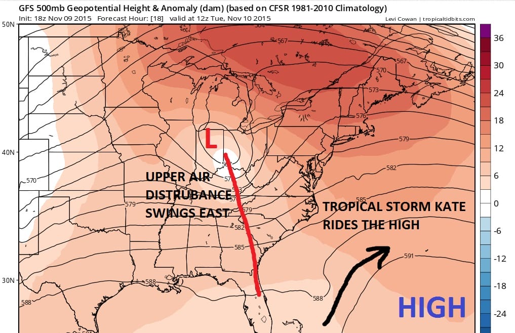
The upper air is pretty straight forward. The upper air distubance gradually lifts northeast and brings rain to our area on Tuesday and then it begins to move to the northeast of us Tuesday night and Wednesday morning. At least the non tropical system is going to bring a half inch to maybe a inch of rain in some places.
There is a new JOESTRADAMUS piece on the long range. The link is below however it will not be available until 6:30pm Eastern time.
SHORT RANGE FORECAST LONG RANGE FORECAST
NEW JOESTRADAMUS ON THE LONG RANGE AVAILABLE AFTER 6:30PM
JOESTRADAMUS WINTER FORECAST FOR 2015-2016
CHRISTMAS SHOPPING ON METEOROLOGISTJOECIOFFI.COM