
Weather Forecasting Models: JOESTRADAMUS On the Long Range Outlook
THANK YOU TROPICAL TIDBITS FOR THE USE OF YOUR MAPS!
The video analysis below illustrates what the weather forecasting models (gfs, European, & Canadian) did last night. The discussion that follows will update this on what the weather forcasting models are showing for today’s day run. The models have been highly volatile for days showing deep storms on one run and strong ridges in the same spots on the next. It has led to confusion on how the longer term (second half of the month ) is going to play out. Again I want to emphasize here that the changes DO NOT necessarily mean that winter weather is imminent or even close to that. It is wise to simply let the pattern play itself out and see where it takes us as November continues to move along.
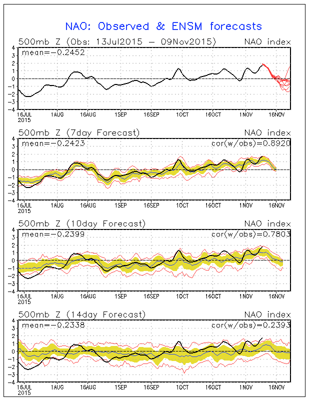
The indicators for the North Atlantic Oscillation and the Atlantic Oscillation continue to show what they have shown for days. The GFS ensemble members which are different versions of the gfs, each with its own set of parameters show the indicators crossing zero and going negative but not all do. In fact what is funny about the NAO indicator is that all the indicators go negative except for one! This sort of reminds me of what happened during Hurricane Joaquin when all the forecast models were showing except 1 where showing a westward track and the one that didn’t showed it (the European) was the one that was correct. Again this is the GFS ensemble members and the one that sticks out in the other direction IS NOT the European. They have their own ensemble group that has been pretty much in line with the GFS for the last week.

Let us assume for now that the trends in the NAO and the AO are correct and let us now examine where today’s day run of weather forecasting models takes us.
The biggest issue in the overall pattern continues to lie in the west where the polar vortex complex remains parked over Alaska and Siberia and over the poles. This reflects the strong patterns right now with the positive NAO and AO peaking out in the next day or 2 before they begin their descent.
The above loop is the GFS over the next 16 days. This takes us through the period from mid month on where the NAO/AO are supposed to go negative. If that continues to be the case then the GFS continues to show the dominance of the polar vortex complex that remains pinned up well north and west into Northwest Canada and Siberia. This continues to cut off any kind of true polar flow into Canada. We continue to see the ridge in the east trying to fly up through day 10, after which at the end of the period it begins some sort of re-alignment. The model continues to push back any change in pattern further and further and now basically has pretty much the same pattern on going for the next 2 weeks. The trough is in the western US and while we do get colder, it is only for a day or two as one of the stronger systems moves into the northeast but all of this remains transient. I want to wait until I see what the ensembles do with all this. Given the volatility of runs, my confidence level is low and my confusion level is high.
The Canadian loop only goes out 10 days and at least through day 10 (November 19th) there really isn’t much different here in the overall look. The same vortex issue is evident in this model as is with the GFS weather model. The bottom line is that there has to be a wholesale breakdown of the pattern and something needs to trigger it. No trigger mechanisms are evident as of yet.
The European model which also only goes out 10 days is pretty much the same story. You can begin to see some changes out in the far northwest toward the end of the period. It is remarkable how similar all three models are this afternoon.
The long range journey continues. Remember folks this is early November. Having a warm Novemeber doesn’t necessarily mean much regarding the winter. The el-nino continues to dominate the overall pattern across the Northern Hemisphere. We continue to see conflicting longer term signals that are creating back and forth model outputs from run to run and we are likely to continue to see them over the coming days. The adventure continues.