Tropical Storm Irma Forms Eastern Atlantic
Tropical Storm Irma Forms Eastern Atlantic
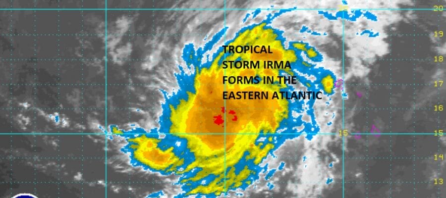
Tropical Storm Irma has formed in the Eastern Atlantic and based on satellite estimates it is roughly at 16N 30W which is about 1800 miles east of the Northern Leeward Islands. There appears to be a well developed core circulation as the loop shows with the bright red showing up on the enhanced satellite loop.

Looking at the wide satellite view you can see that this is a big system. Weather models bring this system to the west northwest or west for the next 5 days. This system is going to be around for awhile and for now, weather models suggest this will make it to at least 70 degrees west in the long range. There will be a strong upper high building across the Atlantic that will be guiding this system along.

Water vaor imagery shows the large upper low in the South Central Atlantic is weakening rapidly which should allow for gradual strengthening over the next five days. Some models due take this to major hurricane status in the long range.

…IRMA FORMS OVER THE FAR EASTERN ATLANTIC…
…NO IMMEDIATE THREAT TO LAND…
SUMMARY OF 1100 AM AST…1500 UTC…INFORMATION
———————————————–
LOCATION…16.4N 30.3W
ABOUT 420 MI…675 KM W OF THE CABO VERDE ISLANDS
MAXIMUM SUSTAINED WINDS…50 MPH…85 KM/H
PRESENT MOVEMENT…W OR 280 DEGREES AT 13 MPH…20 KM/H
MINIMUM CENTRAL PRESSURE…1004 MB…29.65 INCHES
WATCHES AND WARNINGS
——————–
There are no coastal watches or warnings in effect.
DISCUSSION AND 48-HOUR OUTLOOK
——————————
At 1100 AM AST (1500 UTC), the center of Tropical Storm Irma was
located near latitude 16.4 North, longitude 30.3 West. Irma is
moving toward the west near 13 mph (20 km/h) and this general motion
is expected to continue for the next couple of days.
Satellite wind data indicate that the maximum sustained winds are
near 50 mph (85 km/h) with higher gusts. Some strengthening is
forecast during the next 48 hours and Irma could become a hurricane
on Friday.
Tropical-storm-force winds extend outward up to 35 miles (55 km)
from the center.
The estimated minimum central pressure is 1004 mb (29.65 inches).
MANY THANKS TO TROPICAL TIDBITS FOR THE WONDERFUL USE OF THE MAPS
POST SPONSOR
Weather App

Don’t be without Meteorologist Joe Cioffi’s weather app. It is really a meteorologist app because you get my forecasts and my analysis and not some automated computer generated forecast based on the GFS model. This is why your app forecast changes every 6 hours. It is model driven with no human input at all. It gives you an icon, a temperature and no insight whatsoever.
It is a complete weather app to suit your forecast needs. All the weather information you need is right on your phone. Android or I-phone, use it to keep track of all the latest weather information and forecasts. This weather app is also free of advertising so you don’t have to worry about security issues with your device. An accurate forecast and no worries that your device is being compromised.
Use it in conjunction with my website and my facebook and twitter and you have complete weather coverage of all the latest weather and the long range outlook. The website has been redone and upgraded. Its easy to use and everything is archived so you can see how well Joe does or doesn’t do when it comes to forecasts and outlooks.
Just click on the google play button or the apple store button on the sidebar for my app which is on My Weather Concierge. Download the app for free. Subscribe to my forecasts on an ad free environment for just 99 cents a month.
Get my forecasts in the palm of your hand for less than the cost of a cup of Joe!