Tropical Storm Forming Eastern Atlantic
Tropical Storm Forming Eastern Atlantic

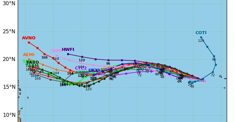
Based on the overnight satellite loops it appears that the disturbed weather with a tropical wave west of the Cabo Verde Island has organized overnight into a tropical depression or perhaps a tropical storm. Advisories will begin at 11am from the National Hurricane Center and this is system is likely to become Tropical Storm Irma. Weather models all march this across to the west over the next 5 days and most models have this becoming a major hurricane over the weekend and into early next week. The wide satellite view however shows how far east this system is so there will be tons of time to watch this.

There may be another area of interest to pay attention to in the coming days and this is not necessarily good news. Pressures over the Western & Southeastern Gulf of Mexico remain low. It is quite possible that another tropical system could emerge in the Southwest Gulf of Mexico in the coming days which will not be good for Harvey ravaged Texas. We need to pay close attention to this possibility. Tropical Storm Harvey is inland now in Southwest Louisiana as the flooding rains have moved out of the Houston Galveston area but they continue this morning in extreme Southeast Texas & Southwest Louisiana.


With Harvey moving slowly further inland the axis of heavy rain will continue to shift north and northeastward as the day progresses but motion is going to be slow.
…CENTER OF HARVEY OVER SOUTHWESTERN LOUISIANA…
…FLOODING RAINS CONTINUING OVER EXTREME SOUTHEASTERN TEXAS AND
SOUTHWESTERN LOUISIANA…
SUMMARY OF 700 AM CDT…1200 UTC…INFORMATION
———————————————-
LOCATION…30.2N 93.6W
ABOUT 25 MI…40 KM WNW OF LAKE CHARLES LOUISIANA
ABOUT 30 MI…50 KM NE OF PORT ARTHUR TEXAS
MAXIMUM SUSTAINED WINDS…45 MPH…75 KM/H
PRESENT MOVEMENT…N OR 360 DEGREES AT 9 MPH…14 KM/H
MINIMUM CENTRAL PRESSURE…992 MB…29.29 INCHES
WATCHES AND WARNINGS
——————–
CHANGES WITH THIS ADVISORY:
None.
SUMMARY OF WATCHES AND WARNINGS IN EFFECT:
A Storm Surge Warning is in effect for…
* Holly Beach Louisiana to Morgan City Louisiana
A Storm Surge Watch is in effect for…
* East of High Island Texas to west of Holly Beach Louisiana
A Tropical Storm Warning is in effect for…
* East of High Island Texas to Grand Isle Louisiana
Catastrophic and life-threatening flooding continues in southeastern
Texas and portions of southwestern Louisiana. Please see warnings
and other products issued by your local National Weather Service
office for additional information on this life-threatening
situation.
A Storm Surge Warning means there is a danger of life-threatening
inundation, from rising water moving inland from the coastline,
during the next 12 hours in the indicated locations. For a
depiction of areas at risk, please see the National Weather
Service Storm Surge Watch/Warning Graphic, available at
hurricanes.gov. This is a life-threatening situation. Persons
located within these areas should take all necessary actions to
protect life and property from rising water and the potential for
other dangerous conditions. Promptly follow evacuation and other
instructions from local officials.
For storm information specific to your area, including possible
inland watches and warnings, please monitor products issued by your
local National Weather Service forecast office.
DISCUSSION AND 48-HOUR OUTLOOK
——————————
At 700 AM CDT (1200 UTC), the center of Tropical Storm Harvey was
located over southwestern Louisiana near latitude 30.2 North,
longitude 93.6 West. Harvey has been moving toward the north at
about 9 mph (14 km/h) for the past several hours. The storm is
expected to move north-northeastward later this morning, and then
a northeastward motion at a faster forward speed is expected through
Thursday night. On the forecast track, the center of Harvey will
move across the Lower Mississippi Valley and Tennessee Valley
through Thursday.
Maximum sustained winds are near 45 mph (75 km/h) with higher gusts.
Gradual weakening is forecast as the center moves farther inland,
and Harvey is expected to become a tropical depression by tonight.
Tropical-storm-force winds extend outward up to 80 miles (130 km)
from the center. A National Ocean Service station at Texas Point,
Texas, recently reported a wind gust of 42 mph (68 km/h), while the
Orange County Airport in Orange, Texas recently reported a wind gust
of 41 mph (66 km/h).
The estimated minimum central pressure based on surface observations
is 992 mb (29.29 inches).
MANY THANKS TO TROPICAL TIDBITS FOR THE WONDERFUL USE OF THE MAPS
Weather App

Don’t be without Meteorologist Joe Cioffi’s weather app. It is really a meteorologist app because you get my forecasts and my analysis and not some automated computer generated forecast based on the GFS model. This is why your app forecast changes every 6 hours. It is model driven with no human input at all. It gives you an icon, a temperature and no insight whatsoever.
It is a complete weather app to suit your forecast needs. All the weather information you need is right on your phone. Android or I-phone, use it to keep track of all the latest weather information and forecasts. This weather app is also free of advertising so you don’t have to worry about security issues with your device. An accurate forecast and no worries that your device is being compromised.
Use it in conjunction with my website and my facebook and twitter and you have complete weather coverage of all the latest weather and the long range outlook. The website has been redone and upgraded. Its easy to use and everything is archived so you can see how well Joe does or doesn’t do when it comes to forecasts and outlooks.
Just click on the google play button or the apple store button on the sidebar for my app which is on My Weather Concierge. Download the app for free. Subscribe to my forecasts on an ad free environment for just 99 cents a month.
Get my forecasts in the palm of your hand for less than the cost of a cup of Joe!