
Tropical Storm Ida seems to be holding its own during the afternoon though if you look at the satellite loop below you can see the upper low to the northwest that has absorbed much of Tropical Depression 9 and the impact of westerly shear over the system.
SUMMARY OF 500 PM AST...2100 UTC...INFORMATION
----------------------------------------------
LOCATION...15.6N 40.8W
ABOUT 1115 MI...1795 KM W OF THE CAPE VERDE ISLANDS
MAXIMUM SUSTAINED WINDS...40 MPH...65 KM/H
PRESENT MOVEMENT...WNW OR 300 DEGREES AT 14 MPH...22 KM/H
MINIMUM CENTRAL PRESSURE...1006 MB...29.71 INCHES
Models are all over the place with Tropical Storm Ida showing anything from a minimal tropical storm to a hurricane later in the period. There i also a wide spread in model forecast track. For the time being this remains only a storm for weather geeks and marine interests. It is interesting on the loop that the three standout systems in the Atlantic all seem to be linked with 2 cold core systems and the one tropical system. Look at the clouds east of the islands shooting northward into the strong upper low. Shear remains everywhere.


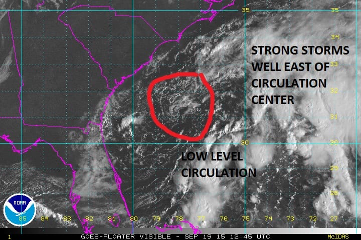
The visible satellite loop above clearly shows a low level circulation has developed. There is very little thunderstorm activity in and around the low center as all the stronger storms are well to the east and south. This is the signature of a non tropical system. Until thunderstorms begin to concentrate themselves around the center we will be dealing with a non tropical system. The transition process if it is going to happen is going to take some time to take place..perhaps a few days. The low center appears to be moving to the east.
Be sure to download my weather app and subscribe to my forecasts. The app is free and the subscription is just 99 cents a month. The app is free of advertisement and there are no tracking or security issues.