TROPICAL STORM HARVEY STRENGTHENING HURRICANE WATCH TEXAS COAST
TROPICAL STORM HARVEY STRENGTHENING
HURRICANE WATCH TEXAS COAST

Reports from an Air Force Plane found a large band of 45 to 60 knot winds at flight level in the northeast quadrant. Harvey has once again reached tropical storm strength
Tropical Storm Harvey Tropical Cyclone Update
NWS National Hurricane Center Miami FL AL092017
1100 PM CDT Wed Aug 23 2017
…AIR FORCE PLANE FINDS TROPICAL STORM FORCE WINDS…
An Air Force Reserve hurricane hunter aircraft just measured
tropical storm force winds in Harvey. The maximum winds are
estimated to be 40 mph (65 km/h) with higher gusts.
SUMMARY OF 1100 PM CDT…0400 UTC…INFORMATION
———————————————-
LOCATION…22.0N 92.6W
ABOUT 500 MI…810 KM SSE OF PORT OCONNOR TEXAS
ABOUT 440 MI…705 KM SE OF PORT MANSFIELD TEXAS
MAXIMUM SUSTAINED WINDS…40 MPH…65 KM/H
PRESENT MOVEMENT…NW OR 325 DEGREES AT 2 MPH…4 KM/H
MINIMUM CENTRAL PRESSURE…1002 MB…29.59 INCHES

The upper low in the Northwest Gulf of Mexico is all but gone now which means that conditions are favorable for gradual strengthening. Tropical Storm Harvey could become a hurricane before making landfall along or near the South Texas Coast Friday night or early Saturday morning

Model guidance has shifted a bit west and south during the evening but the same premise remains. Tropical Storm Harvey will slow down or even stall somewhere in South Texas creating a massive rainfall for much of East Texas over the weekend.
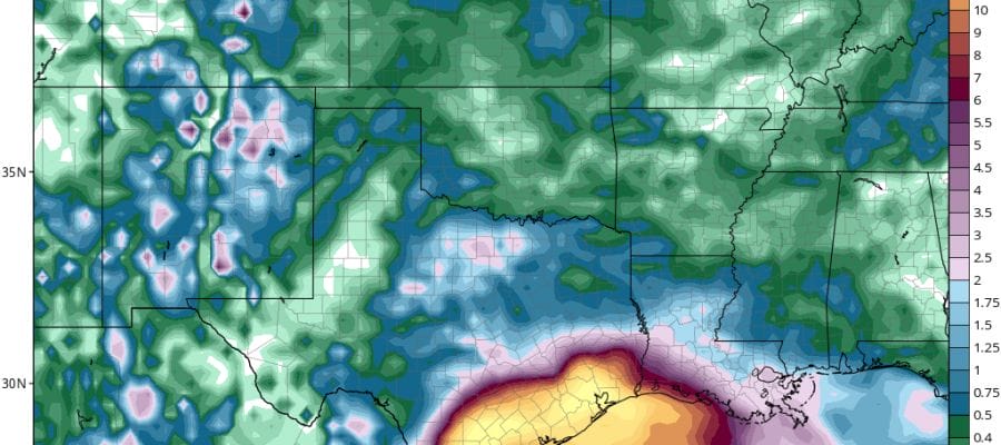
GFS RAINFALL FORECAST TROPICAL STORM HARVEY
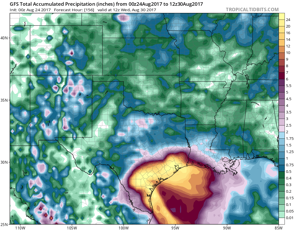
The GFS model has gotten more aggressive with intensity raising this to a category 3 hurricane before landfall. It should be STRONGLY noted that intensity forecasts are very difficult and volatile in both directions.
MANY THANKS TO TROPICAL TIDBITS FOR THE WONDERFUL USE OF THE MAPS
Weather App

Don’t be without Meteorologist Joe Cioffi’s weather app. It is really a meteorologist app because you get my forecasts and my analysis and not some automated computer generated forecast based on the GFS model. This is why your app forecast changes every 6 hours. It is model driven with no human input at all. It gives you an icon, a temperature and no insight whatsoever.
It is a complete weather app to suit your forecast needs. All the weather information you need is right on your phone. Android or I-phone, use it to keep track of all the latest weather information and forecasts. This weather app is also free of advertising so you don’t have to worry about security issues with your device. An accurate forecast and no worries that your device is being compromised.
Use it in conjunction with my website and my facebook and twitter and you have complete weather coverage of all the latest weather and the long range outlook. The website has been redone and upgraded. Its easy to use and everything is archived so you can see how well Joe does or doesn’t do when it comes to forecasts and outlooks.
Just click on the google play button or the apple store button on the sidebar for my app which is on My Weather Concierge. Download the app for free. Subscribe to my forecasts on an ad free environment for just 99 cents a month.
Get my forecasts in the palm of your hand for less than the cost of a cup of Joe!