Harvey Strengthening Rapidly Hurricane Warnings Posted
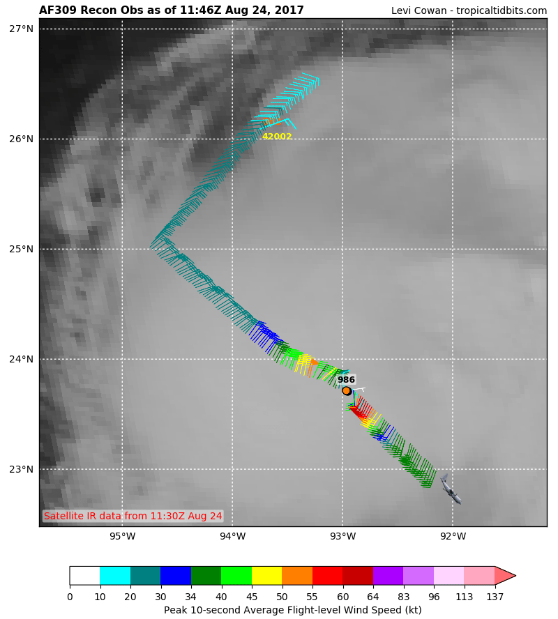
AF RECON REPORT COURTESY OF TROPICAL TIDBITS
Harvey Strengthening Rapidly Hurricane Warnings Posted
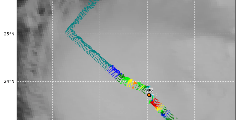
Reports from the latest aircraft mission which is still underway found the a the lowes pressure has dropped 16 millibars in the last 8 hours or at a rate of 2 millibars per hour. Flight level winds of 60 knots are being indicated very close to the center. The plane has yet to sample the winds on the northeast side. The satellite loop this morning shows that Harvey continues to get better organized and should strengthen to a hurricane later today.

..AIR FORCE HURRICANE HUNTER PLANE FINDS HARVEY STRENGTHENING…
SUMMARY OF 700 AM CDT…1200 UTC…INFORMATION
———————————————-
LOCATION…23.8N 93.0W
ABOUT 380 MI…615 KM SE OF PORT OCONNOR TEXAS
ABOUT 335 MI…540 KM SE OF PORT MANSFIELD TEXAS
MAXIMUM SUSTAINED WINDS…60 MPH…95 KM/H
PRESENT MOVEMENT…NNW OR 345 DEGREES AT 10 MPH…17 KM/H
MINIMUM CENTRAL PRESSURE…986 MB…29.12 INCHES
WATCHES AND WARNINGS
——————–
CHANGES WITH THIS ADVISORY:
None.
SUMMARY OF WATCHES AND WARNINGS IN EFFECT:
A Storm Surge Warning is in effect for…
* Port Mansfield to San Luis Pass Texas
A Storm Surge Watch is in effect for…
* South of Port Mansfield Texas to the Mouth of the Rio Grande
* North of San Luis Pass to High Island Texas
A Hurricane Warning is in effect for…
* Port Mansfield to Matagorda Texas
A Tropical Storm Warning is in effect for…
* North of Matagorda to High Island Texas
* South of Port Mansfield Texas to the Mouth of the Rio Grande
A Hurricane Watch is in effect for…
* South of Port Mansfield Texas to the Mouth of the Rio Grande
A Tropical Storm Watch is effect for…
* South of the Mouth of the Rio Grande to Boca de Catan Mexico
A Storm Surge Warning means there is a danger of life-threatening
inundation, from rising water moving inland from the coastline,
during the next 36 hours in the indicated locations. For a
depiction of areas at risk, please see the National Weather
Service Storm Surge Watch/Warning Graphic, available at
hurricanes.gov. This is a life-threatening situation. Persons
located within these areas should take all necessary actions to
protect life and property from rising water and the potential for
other dangerous conditions. Promptly follow evacuation and other
instructions from local officials.
A Hurricane Warning means that hurricane conditions are expected
somewhere within the warning area. A warning is typically issued
36 hours before the anticipated first occurrence of tropical-storm-
force winds, conditions that make outside preparations difficult or
dangerous. Preparations to protect life and property should be
rushed to completion.
A Tropical Storm Warning means that tropical storm conditions are
expected somewhere within the warning area within 36 hours.
A Storm Surge Watch means there is a possibility of life-
threatening inundation, from rising water moving inland from the
coastline, in the indicated locations during the next 48 hours.
A Hurricane Watch means that hurricane conditions are possible
within the watch area.
A Tropical Storm Watch means that tropical storm conditions are
possible within the watch area.
In addition, interests in southwestern Louisiana should continue to
monitor the progress of this system.
For storm information specific to your area in the United
States, including possible inland watches and warnings, please
monitor products issued by your local National Weather Service
forecast office. For storm information specific to your area outside
the United States, please monitor products issued by your national
meteorological service.
DISCUSSION AND 48-HOUR OUTLOOK
——————————
At 700 AM CDT (1200 UTC), the center of Tropical Storm Harvey was
located by a reconnaissance plane near latitude 23.8 North,
longitude 93.0 West. Harvey is moving toward the north-northwest
near 10 mph (17 km/h). A track toward the northwest or
north-northwest at a faster forward speed is expected for the next
48 hours. On the forecast track, Harvey will approach the southern
Texas coast on Friday.
An Air Force Reserve aircraft reports that the maximum sustained
winds have increased to near 60 mph (95 km/h) with higher gusts.
Additional strengthening is forecast during the next 48 hours, and
Harvey is expected to become a hurricane by Friday.
Tropical-storm-force winds extend outward up to 115 miles (185 km)
from the center.
The minimum central pressure based on data from the Air Force
Hurricane Hunter aircraft is 986 mb (29.12 inches).

The upper low in the Northwest Gulf of Mexico is gone now which means that conditions are favorable for rapidl strengthening. I think there is a good chance that if this strengthening trend continues Harvey could eventually reach category 2 or 3 strength before landfall somewhere near or just north of Corpus Christi Texas

Model guidance has shifted a bit west and south during the evening but the same premise remains. Harvey will slow down or even stall somewhere in South Texas creating a massive rainfall for much of East Texas over the weekend.
GFS RAINFALL FORECAST TROPICAL STORM HARVEY
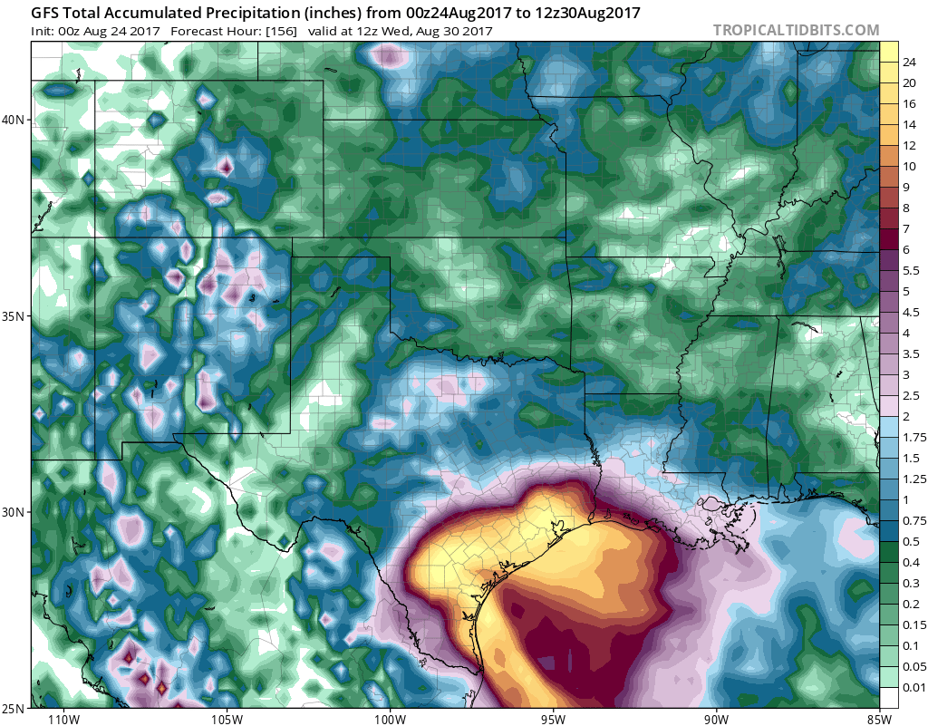
The GFS model has gotten very aggressive with intensity raising this to a category 3 hurricane before landfall. It should be STRONGLY noted that intensity forecasts are very difficult and volatile in both directions.
MANY THANKS TO TROPICAL TIDBITS FOR THE WONDERFUL USE OF THE MAPS
Weather App

Don’t be without Meteorologist Joe Cioffi’s weather app. It is really a meteorologist app because you get my forecasts and my analysis and not some automated computer generated forecast based on the GFS model. This is why your app forecast changes every 6 hours. It is model driven with no human input at all. It gives you an icon, a temperature and no insight whatsoever.
It is a complete weather app to suit your forecast needs. All the weather information you need is right on your phone. Android or I-phone, use it to keep track of all the latest weather information and forecasts. This weather app is also free of advertising so you don’t have to worry about security issues with your device. An accurate forecast and no worries that your device is being compromised.
Use it in conjunction with my website and my facebook and twitter and you have complete weather coverage of all the latest weather and the long range outlook. The website has been redone and upgraded. Its easy to use and everything is archived so you can see how well Joe does or doesn’t do when it comes to forecasts and outlooks.
Just click on the google play button or the apple store button on the sidebar for my app which is on My Weather Concierge. Download the app for free. Subscribe to my forecasts on an ad free environment for just 99 cents a month.
Get my forecasts in the palm of your hand for less than the cost of a cup of Joe!