
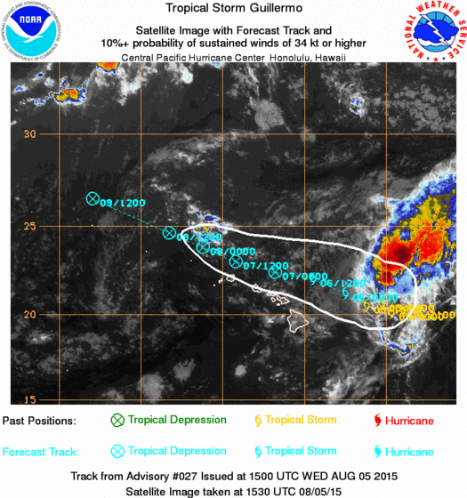
LOCATION…20.5N 151.2W
ABOUT 260 MI…415 KM ENE OF HILO HAWAII
ABOUT 435 MI…700 KM E OF HONOLULU HAWAII
MAXIMUM SUSTAINED WINDS…60 MPH…95 KM/H
PRESENT MOVEMENT…WNW OR 290 DEGREES AT 9 MPH…15 KM/H
MINIMUM CENTRAL PRESSURE…999 MB…29.50 INCHES
The northward shift over the last few days was enough to take the center of the tropical storm a reasonable distance north of the Hawaiian chain based on all the latest models and forecasts.
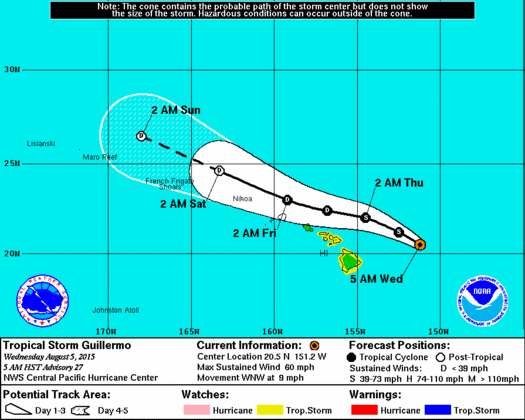
While max winds are still at around 60 mph the conditions are hostile over the tropical storm and there should be a gradual weakening trend that will commence shortly. It is not all that impressive on the satellite and it is likely that the circulation center is exposed and a way from the main air of convection which is an indicator of strong westerly winds aloft shearing off the tops of any developing thunderstorms.
No tropical storm warnings are up for the island though they are up for coastal waters and it appears that gale force winds will be confined to offshore areas though rough seas will occur all around the island chain but in particular to the north facing beaches. If you are travelling to Hawaii or have friends and relatives there, I believe there is no concern here regarding any direct hit. The tropical storm is forecast to weaken to a depression over the next 2 days as it continues on a west northwest course.