Tropical Storm Franklin Could Develop Tonight or Monday

Tropical Storm Franklin Could Develop Tonight or Monday Tropical Storm Warnings Posted for Parts of Mexico Southward

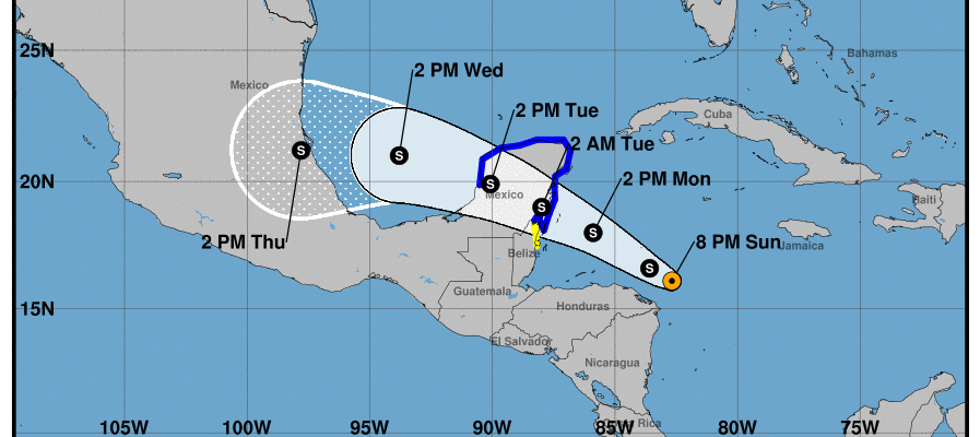
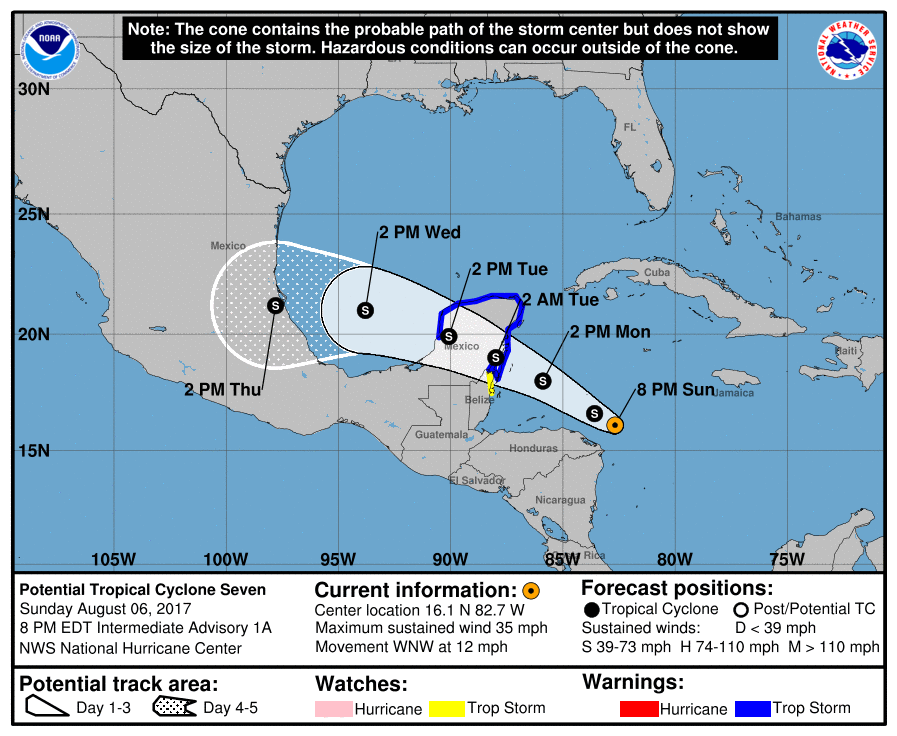
Satellite loops and surface data indicate that the disturbed weather in the Western Caribbean has gotten better organized and may be close to tropical storm strength. Tropical Storm Warnings have been posted for portions of the Yucatan Peninsula southward through Belize. It is anticipated that this system will strengthen to a tropical storm overnight or on Monday.
…DISTURBANCE EXPECTED TO BECOME A TROPICAL STORM OVERNIGHT…
SUMMARY OF 800 PM EDT…0000 UTC…INFORMATION
———————————————-
LOCATION…16.1N 82.7W
ABOUT 85 MI…135 KM NNE OF CABO GRACIAS A DIOS ON NIC/HON BORDER
ABOUT 405 MI…650 KM ESE OF CHETUMAL MEXICO
MAXIMUM SUSTAINED WINDS…35 MPH…55 KM/H
PRESENT MOVEMENT…WNW OR 290 DEGREES AT 12 MPH…19 KM/H
MINIMUM CENTRAL PRESSURE…1007 MB…29.74 INCHES
WATCHES AND WARNINGS
——————–
CHANGES WITH THIS ADVISORY:
None
SUMMARY OF WATCHES AND WARNINGS IN EFFECT:
A Tropical Storm Warning is in effect for…
* The coast of Mexico from Chetumal to Campeche
A Tropical Storm Watch is in effect for…
* Belize City northward to the border of Mexico
A Tropical Storm Warning means that tropical storm conditions are
expected somewhere within the warning area, in this case within 24
to 36 hours.
A Tropical Storm Watch means that tropical storm conditions are
possible within the watch area, in this case within 24 to 36 hours.
Interests elsewhere around the Bay of Campeche should monitor the
progress of this system.
For storm information specific to your area, please monitor
products issued by your national meteorological service.
DISCUSSION AND 48-HOUR OUTLOOK
——————————
At 800 PM EDT (0000 UTC), the disturbance was centered near latitude
16.1 North, longitude 82.7 West. The system is moving toward the
west-northwest near 12 mph (19 km/h) and this general motion is
expected to continue over the next 48 hours. On the forecast track,
the center will pass north of Honduras tonight and early Monday,
then approach the east coast of the Yucatan peninsula Monday
afternoon. The system is forecast to move across Yucatan Peninsula
Monday night and Tuesday.
Maximum sustained winds are near 35 mph (55 km/h) with higher
gusts, and an increase in strength is forecast during the next day
or so.
Upper-level winds are becoming more conducive for development, and
the disturbance is likely to become a tropical cyclone overnight.
* Formation chance through 48 hours…high…90 percent
* Formation chance through 5 days…high…90 percent
The estimated minimum central pressure is 1007 mb (29.74 inches).

This system will cross the Yucatan Peninsula and then emerge into the Southwest Gulf of Mexico where it may have time to reach hurricane strength as it moves westward. This is not expected to impact the United States as the upper air pattern favors a westerly track over the next 4 days.
As far as the tropical wave in the East Central Atlantic is concerned, it continues to remain disorganized and conditions do not seem to favor development of this system going forward as upper air conditions are likely to grow hostile over the Tropical Atlantic over the next few days.
Weather App

Don’t be without Meteorologist Joe Cioffi’s weather app. It is really a meteorologist app because you get my forecasts and my analysis and not some automated computer generated forecast based on the GFS model. This is why your app forecast changes every 6 hours. It is model driven with no human input at all. It gives you an icon, a temperature and no insight whatsoever.
It is a complete weather app to suit your forecast needs. All the weather information you need is right on your phone. Android or I-phone, use it to keep track of all the latest weather information and forecasts. This weather app is also free of advertising so you don’t have to worry about security issues with your device. An accurate forecast and no worries that your device is being compromised.
Use it in conjunction with my website and my facebook and twitter and you have complete weather coverage of all the latest weather and the long range outlook. The website has been redone and upgraded. Its easy to use and everything is archived so you can see how well Joe does or doesn’t do when it comes to forecasts and outlooks.
Just click on the google play button or the apple store button on the sidebar for my app which is on My Weather Concierge. Download the app for free. Subscribe to my forecasts on an ad free environment for just 99 cents a month.
Get my forecasts in the palm of your hand for less than the cost of a cup of Joe!
![]()
![]()

MENTION JOE CIOFFI AND GET A 5% DISCOUNT