
Tropical Storm Eta Tropical Storm Watch Florida West Coast
Rain Coming to the East Late Wednesday

Weather in 5/Joe & Joe Weather Show Latest Podcast
Tropical Storm Eta Tropical Storm Watch Florida West Coast
Rain Coming to the East Late Wednesday
Tropical Storm Eta has been organizing today to the west southwest of Key West Florida. it has also started moving northward as it is embedded inside a large upper low that covers much of the Eastern Gulf and the Southeast US. That has prompted the Hurricane Center to put Tropical Storm Watches up for the Florida west coast from Englewood Florida north to the Suwannee River which includes Tampa Saint Petersburg. Right now much of the weather over Florida is quiet but we could see that change along the west coast during Wednesday and Thursday. There is an outside chance Eta could strengthen into a hurricane before hitting cooler water and stronger upper air winds once it gets north of 27 degrees north.
SATELLITE

REGIONAL RADAR
E

Monitoring the regional and local radars we can see the rain from Eta is still to the southeast of Key West and moving northward. On the mainland there some scattered bands of showers moving south to north but for now they are few and far between.
LOCAL RADAR MIAMI FL

LOCAL RADAR KEY WEST FL

The National Hurricane Center forecast track takes it slowly northward. A cold front is approaching from the Northwest and most of the hurricane models pull the moisture northward but they leave the circulation behind as a remnant low late this week or this weekend. Recent runs of global models take Eta northeast into the coastal bend of Florida late Thursday and bring it out as a weakening low off the Southeast coast Friday, eventually getting absorbed by the front as it goes by.
LOCAL RADAR KEY WEST FL


Meanwhile here in the Northeast and Mid Atlantic states it was another beautiful day of sunshine and record highs in the low to mid 70s. Skies have started clear tonight but the wind has picked up a bit from the south as the high is now well offshore. Lows tonight will be in the warm 50s to near 60. This is where our daytime highs should normally be this time of year! Nothing is on the radar to worry about for the time being.
SATELLITE

REGIONAL RADAR

Everything remains on course for Wednesday with increasing clouds and warm temperatures. Highs will be in the upper 60s and lower 70s in most places. Showers will be moving across Pennsylvania during the day and will likely reach the coast Wednesday evening.

I split the nam model in two with the one above ending at 1am Thursday and the one below starting at 1am Thursday and ending 1am Saturday.
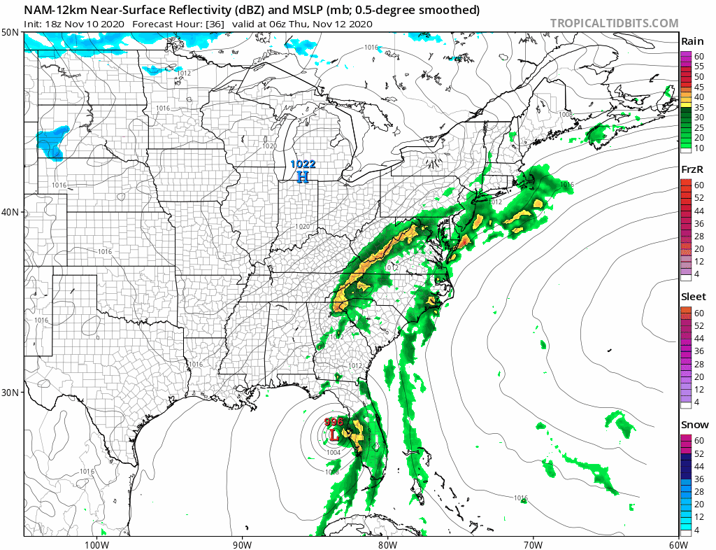
Rain will continue into early afternoon Thursday but the front has a tough time moving east. A second wave might bring another round of rain or showers on Friday for the first part of the day before we finally see genuine improvement. The model takes Tropical Storm Eta across Florida and then the cold front absorbs it. This is actually a good thing for us because it gets the system out of the way and it can’t complicate the weekend. Right now the weekend looks to be mostly dry and chilly. Temperatures Thursday will settle in the 50s later in the day. Friday and Saturday highs will be in the 50s.
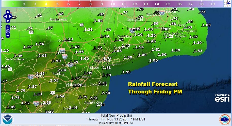
Rainfall amounts of 1 to 2 inches will be common from the Wednesday night through Friday afternoon rain. Higher amounts will be from Southern New Jersey southward where 2 to 3 inches are possible. Amounts less once you move north of Southern New England.
BE SURE TO DOWNLOAD THE FREE METEOROLOGIST JOE CIOFFI WEATHER APP &
ANGRY BEN’S FREE WEATHER APP “THE ANGRY WEATHERMAN!
MANY THANKS TO TROPICAL TIDBITS FOR THE USE OF MAPS
Please note that with regards to any severe weather, tropical storms, or hurricanes, should a storm be threatening, please consult your local National Weather Service office or your local government officials about what action you should be taking to protect life and property.


