Tropical Storm Earl Moving West
[brid video=”57155″ player=”6390″ title=”earl”]
Tropical Storm Earl Moving West
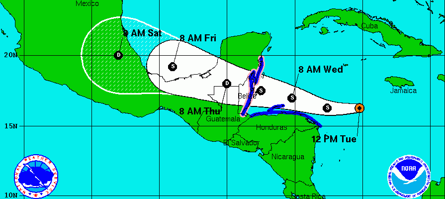
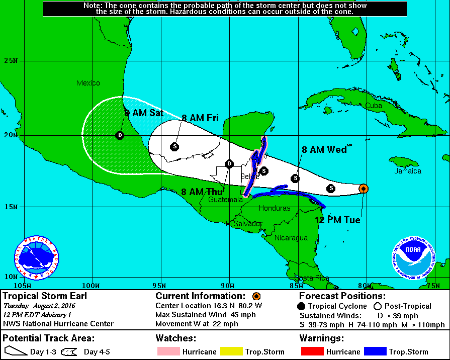
Latest satellite and observations show that Tropical Storm Earl is strengthening this afternoon. Top winds are now 50 mph as it continues to move to the west at about 20 mph. The latest advisory from the National Hurricane Center on Tropical Storm Earl follows.

...EARL A LITTLE STRONGER...


SUMMARY OF 200 PM EDT...1800 UTC...INFORMATION
-----------------------------------------------
LOCATION...16.3N 80.8W
ABOUT 210 MI...340 KM S OF GRAND CAYMAN
MAXIMUM SUSTAINED WINDS...50 MPH...85 KM/H
PRESENT MOVEMENT...W OR 270 DEGREES AT 22 MPH...35 KM/H
MINIMUM CENTRAL PRESSURE...1002 MB...29.59 INCHES


WATCHES AND WARNINGS
--------------------
CHANGES WITH THIS ADVISORY:

NONE

SUMMARY OF WATCHES AND WARNINGS IN EFFECT:

A TROPICAL STORM WARNING IS IN EFFECT FOR...
* PUNTA ALLEN, MEXICO, SOUTHWARD TO THE BELIZE/GUATEMALA BORDER
* CABO GRACIAS A DIOS WESTWARD TO THE HONDURAS/GUATEMALA BORDER
INCLUDING THE BAY ISLANDS

A HURRICANE WATCH IS IN EFFECT FOR...
* EAST COAST OF THE YUCATAN PENINSULA FROM PUNTA ALLEN, MEXICO,
SOUTHWARD TO THE BELIZE/GUATEMALA BORDER

A TROPICAL STORM WATCH IS IN EFFECT FOR...
* THE CAYMAN ISLANDS

A TROPICAL STORM WARNING MEANS THAT TROPICAL STORM CONDITIONS ARE
EXPECTED SOMEWHERE WITHIN THE WARNING AREA WITHIN 36 HOURS.

A HURRICANE WATCH MEANS THAT HURRICANE CONDITIONS ARE POSSIBLE
WITHIN THE WATCH AREA.  A WATCH IS TYPICALLY ISSUED 48 HOURS
BEFORE THE ANTICIPATED FIRST OCCURRENCE OF TROPICAL-STORM-FORCE
WINDS, CONDITIONS THAT MAKE OUTSIDE PREPARATIONS DIFFICULT OR
DANGEROUS.

FOR STORM INFORMATION SPECIFIC TO YOUR AREA, PLEASE MONITOR
PRODUCTS ISSUED BY YOUR NATIONAL METEOROLOGICAL SERVICE.


DISCUSSION AND 48-HOUR OUTLOOK
------------------------------
AT 200 PM EDT (1800 UTC), THE CENTER OF TROPICAL STORM EARL WAS
LOCATED NEAR LATITUDE 16.3 NORTH, LONGITUDE 80.8 WEST. EARL IS
MOVING TOWARD THE WEST NEAR 22 MPH (35 KM/H), AND THIS MOTION
WITH A DECREASE IN FORWARD SPEED IS EXPECTED DURING THE NEXT
COUPLE OF DAYS.  ON THIS TRACK, THE CENTER OF EARL WILL BE MOVING
VERY CLOSE TO THE NORTH COAST OF HONDURAS LATE TONIGHT AND
WEDNESDAY AND APPROACH BELIZE AND THE YUCATAN PENINSULA LATE
WEDNESDAY.

MAXIMUM SUSTAINED WINDS HAVE INCREASED TO NEAR 50 MPH (85 KM/H)
WITH HIGHER GUSTS. SOME ADDITIONAL STRENGTHENING IS FORECAST
BEFORE EARL REACHES THE YUCATAN PENINSULA.

TROPICAL-STORM-FORCE WINDS EXTEND OUTWARD UP TO 80 MILES (130 KM)
FROM THE CENTER.

THE MINIMUM CENTRAL PRESSURE ESTIMATED FROM AN AIR FORCE PLANE WAS
1002 MB (29.59 INCHES).


With the strong ridge to the north and the very deep easterly trade winds, Earl will continue westward though it may slow down as the ridge in the north weakens a little over the next few days.
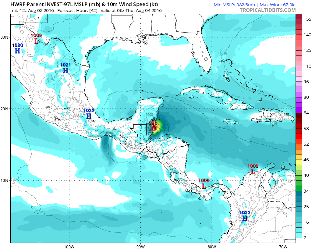
The most aggressive of the models in terms of strength is the HWRF model which develops this into a hurricane this afternoon before it moves inland over Belize. The forecast track westward seems pretty straight foward as there is no real weakness to the north to allow the hurricane to head into the Northwest Caribbean or threaten the United States Gulf Coast.
FiOS1 News Weather Forecast For Long Island
FiOS1 News Weather Forecast For New Jersey
FiOS1 News Weather Forecast For Hudson Valley
NATIONAL WEATHER SERVICE SNOW FORECASTS
LATEST JOESTRADAMUS ON THE LONG RANGE
Weather App

Don’t be without Meteorologist Joe Cioffi’s weather app. It is really a meteorologist app because you get my forecasts and my analysis and not some automated computer generated forecast based on the GFS model. This is why your app forecast changes every 6 hours. It is model driven with no human input at all. It gives you an icon, a temperature and no insight whatsoever.
It is a complete weather app to suit your forecast needs. All the weather information you need is right on your phone. Android or I-phone, use it to keep track of all the latest weather information and forecasts. This weather app is also free of advertising so you don’t have to worry about security issues with your device. An accurate forecast and no worries that your device is being compromised.
Use it in conjunction with my website and my facebook and twitter and you have complete weather coverage of all the latest weather and the long range outlook. The website has been redone and upgraded. Its easy to use and everything is archived so you can see how well Joe does or doesn’t do when it comes to forecasts and outlooks.
Just click on the google play button or the apple store button on the sidebar for my app which is on My Weather Concierge. Download the app for free. Subscribe to my forecasts on an ad free environment for just 99 cents a month.
Get my forecasts in the palm of your hand for less than the cost of a cup of Joe!