
Tropical Storm Dolly Forms Well Offshore While Our Summer Weather Continues
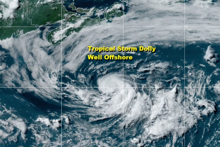
That pesky low that sat over Eastern North Carolina for days and then moved slowly northeast sat over the Gulf Stream waters and lo and behold the season’s fourth tropical storm Dolly formed today. It went from being a subtropical depression to a tropical system as the system organized rather quickly with a core of thunderstorms that developed near the contracting center. It has actually gained a little strength this afternoon and top winds are 45 mph. It gets another name out of the way and Dolly will likely become a remnant low as it moves northeast tonight and Wednesday. It obviously has no impact on our weather here.
SATELLITE

Meanwhile it was another summery day of very warm to hot temperatures. Highs reached the mid 80s to low 90s though the wind off the ocean kept temperatures in check to an extent. The satellite is showing some clouds tops blowing up to our west where some thunderstorms are showing up on the regional radar in Western Pennsylvania and Western NY moving eastward.
REGIONAL RADAR

So far this evening only some scattered pop up showers and thunderstorms are being depicted on the local radars and they are few and far between. The vast majority of you won’t see a thing this evening out of this. The storms to the west will hold up for awhile but I look for them to weaken a bit as they move eastward tonight. Some showers and thunderstorms are possible later on tonight as a weak cold front pushes eastward. Most lows will be in the mid 60s to lower 70s.
LOCAL RADAR NEW YORK CITY

LOCAL RADAR PHILADELPHIA


On to Wednesday where we will see clouds and some sunshine, another very warm and humid day with highs reaching the mid to upper 80s. There is the chance for a scattered shower or thunderstorm in the afternoon and evening. Again most of you won’t see much. It is actually becoming rather dry across the Northeast and Middle Atlantic states
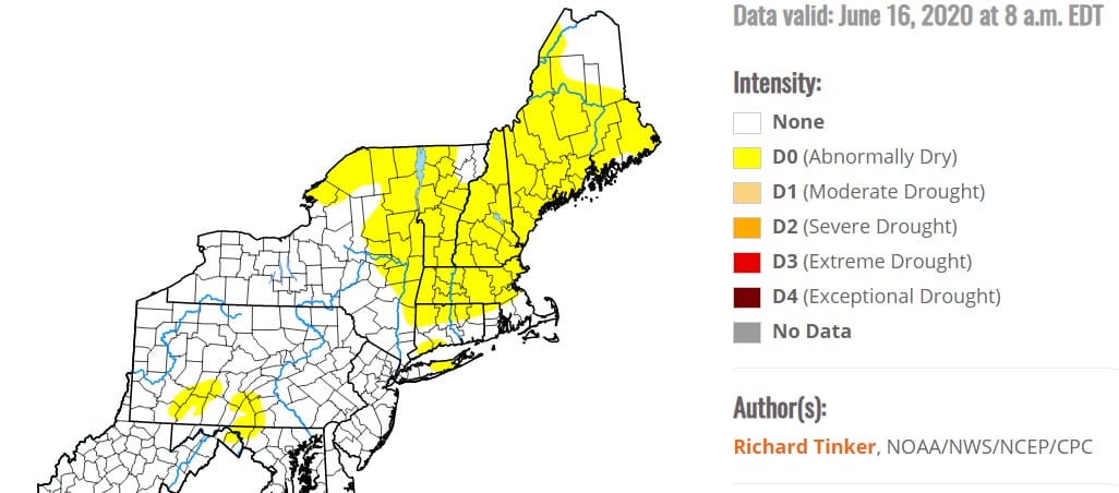
The very hot weather in New England has created abnormally dry conditions there and it extends south to parts of Long Island. Dry conditons cover parts of the Upper Hudson Valley and Northeast NY. Also some pockets of dry conditions are showing up in Southwestern Pennsylvania. A day or two of widespread thunderstorms would alleviate these conditions but we don’t see much in the way of thunderstorms over the next several days.

Back to our weather outlook and we see the chance for a pop up shower or thunderstorm on Thursday but there should also be a fair amount of sun with slightly lower humidity. Highs will be in the 80s. Friday looks sunny with highs in the 80s. Then over the weekend we will be back to very warm to hot conditions with some sunshine and the risk for a pop up shower or thunderstorm though they will be more numerous to the north on Saturday. They will be more scattered on Sunday. Highs both days will be in the 80s to near 90 degrees. Next week is a big vacation week though most of us are still pretty much on vacation. Look for perhaps a bit of a break coming late Monday with a weak cold front and perhaps cooler for a day or so Tuesday and Wednesday before it heats up for the 4th of July weekend.
BE SURE TO DOWNLOAD THE FREE METEOROLOGIST JOE CIOFFI WEATHER APP &
ANGRY BEN’S FREE WEATHER APP “THE ANGRY WEATHERMAN!
MANY THANKS TO TROPICAL TIDBITS FOR THE USE OF MAPS
Please note that with regards to any severe weather, tropical storms, or hurricanes, should a storm be threatening, please consult your local National Weather Service office or your local government officials about what action you should be taking to protect life and property.


