Tropical Storm Colin Moving Inland

Tropical Storm Colin Moving Inland In North Florida
Will Straddle Carolinas & Strengthen Some Moving Northeast
Tropical Storm Colin Moving Inland Current Satellite Loop

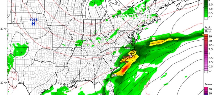
Satellite and radars show Colin has moved inland over the Florida big bend area and now the exposed low center will make its way to the east coast emerging off South Carolina or Georgia in the morning. Due to the strong upper air vortex and energy coming around it, Colin might actually strengthen some as it moves northeast, much the same way as non tropical systems do. Rain continues as shown on the radars below and will continue in the Carolinas on Tuesday while weather conditions improve in Florida.
Tropical Storm Colin Moving Inland..Real Time Radar Loops


SUMMARY OF 1100 PM EDT...0300 UTC...INFORMATION
-----------------------------------------------
LOCATION...29.8N 83.8W
ABOUT 70 MI...115 KM E OF APALACHICOLA FLORIDA
ABOUT 65 MI...105 KM NW OF CEDAR KEY FLORIDA
MAXIMUM SUSTAINED WINDS...50 MPH...85 KM/H
PRESENT MOVEMENT...NE OR 50 DEGREES AT 22 MPH...35 KM/H
MINIMUM CENTRAL PRESSURE...1002 MB...29.59 INCHES


WATCHES AND WARNINGS
--------------------
CHANGES WITH THIS ADVISORY:

None.

SUMMARY OF WATCHES AND WARNINGS IN EFFECT:

A Tropical Storm Warning is in effect for...
* Indian Pass to Englewood
* Sebastian Inlet Florida to Oregon Inlet North Carolina

A Tropical Storm Warning means that tropical storm conditions are
expected somewhere within the warning area.

For storm information specific to your area, including possible
inland watches and warnings, please monitor products issued by your
local National Weather Service forecast office.


DISCUSSION AND 48-HOUR OUTLOOK
------------------------------
At 1100 PM EDT (0300 UTC), the center of Tropical Storm Colin was
located near latitude 29.8 North, longitude 83.8 West.  Colin is
moving toward the northeast near 23 mph (37 km/h).  A continued
northeastward motion at a faster forward speed is expected over the
next 48 hours.  On the forecast track, the center of Colin will
move onshore in the Florida Big Bend area shortly, then move across
northern Florida and southeastern Georgia through early Tuesday
morning, and move near or over the southeastern coast of the United
States Tuesday.  However, it's important to note that the strongest
winds and heaviest rains are well removed from the center.

Maximum sustained winds are near 50 mph (85 km/h) with higher gusts.
Some strengthening is forecast after Colin moves into the Atlantic
on Tuesday.

Tropical-storm-force winds extend outward up to 230 miles (370 km)
from the center.

The estimated minimum central pressure is 1002 mb (29.59 inches).
Tropical Storm Colin Moving Inland..GFS FORECAST 8AM TUESDAY

Tropical Storm Colin is moving very fast at over 25 mph and will accelerate to the northeast on Tuesday. It will have no impact on our weather here at all except for roughing up the ocean for a day or so as it moves east of us.
JOESTRADAMUS HURRICANE SEASON GUEST FORECAST
FiOS1 News Weather Forecast For Long Island
FiOS1 News Weather Forecast For New Jersey
FiOS1 News Weather Forecast For Hudson Valley
NATIONAL WEATHER SERVICE SNOW FORECASTS
LATEST JOESTRADAMUS ON THE LONG RANGE
Weather App

Don’t be without Meteorologist Joe Cioffi’s weather app. It is really a meteorologist app because you get my forecasts and my analysis and not some automated computer generated forecast based on the GFS model. This is why your app forecast changes every 6 hours. It is model driven with no human input at all. It gives you an icon, a temperature and no insight whatsoever.
It is a complete weather app to suit your forecast needs. All the weather information you need is right on your phone. Android or I-phone, use it to keep track of all the latest weather information and forecasts. This weather app is also free of advertising so you don’t have to worry about security issues with your device. An accurate forecast and no worries that your device is being compromised.
Use it in conjunction with my website and my facebook and twitter and you have complete weather coverage of all the latest weather and the long range outlook. The website has been redone and upgraded. Its easy to use and everything is archived so you can see how well Joe does or doesn’t do when it comes to forecasts and outlooks.
Just click on the google play button or the apple store button on the sidebar for my app which is on My Weather Concierge. Download the app for free. Subscribe to my forecasts on an ad free environment for just 99 cents a month.
Get my forecasts in the palm of your hand for less than the cost of a cup of Joe!
![]()
![]()

MENTION JOE CIOFFI AND GET A 5% DISCOUNT