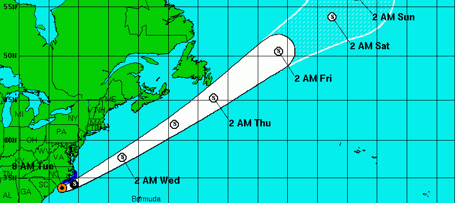
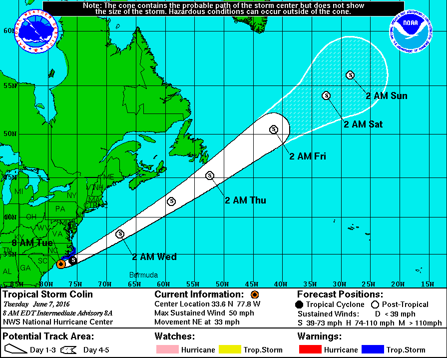
Colin Moving Rapidly Northeast

Colin Moving Rapidly Northeast Weather Conditions
Improving Over Florida and Southeast US
Tropical Storm Colin emerged off the Georgia coast early this morning and we are seeing Colin Moving Rapidly Northeast. Weather conditions from Florida into Southeast North Carolina are improving fairly quickly and much of the rain now is done except for the Eastern North Carolina and that rain will move out later today.
Colin Moving Rapidly Northeast Satellite Loop

Colin Moving Rapidly Northeast Radar Loops


...COLIN BRINGING HEAVY RAINFALL AND GUSTY WINDS TO THE
OUTER BANKS OF NORTH CAROLINA...


SUMMARY OF 800 AM EDT...1200 UTC...INFORMATION
----------------------------------------------
LOCATION...33.6N 77.8W
ABOUT 45 MI...75 KM S OF WILMINGTON NORTH CAROLINA
ABOUT 170 MI...280 KM SW OF CAPE HATTERAS NORTH CAROLINA
MAXIMUM SUSTAINED WINDS...50 MPH...85 KM/H
PRESENT MOVEMENT...NE OR 50 DEGREES AT 33 MPH...54 KM/H
MINIMUM CENTRAL PRESSURE...1000 MB...29.53 INCHES


WATCHES AND WARNINGS
--------------------
CHANGES WITH THIS ADVISORY:

The Tropical Storm Warning is discontinued along the Atlantic coast
south of Surf City, North Carolina.

SUMMARY OF WATCHES AND WARNINGS IN EFFECT:

A Tropical Storm Warning is in effect for...
* Surf City to Oregon Inlet North Carolina

For storm information specific to your area, including possible
inland watches and warnings, please monitor products issued by your
local National Weather Service forecast office.


DISCUSSION AND 48-HOUR OUTLOOK
------------------------------
Satellite and surface observations indicate that Colin's
circulation is becoming less defined and Colin could lose its
status as a tropical cyclone by this afternoon.

At 800 AM EDT (1200 UTC), the center of Tropical Storm Colin was
estimated to be near latitude 33.6 North, longitude 77.8 West.
Colin is moving toward the northeast near 33 mph (54 km/h) and this
motion is expected to continue with an increase in forward speed
today and tonight.  On the forecast track, the center of Colin
should move near and parallel to the coast of North Carolina this
this morning, then offshore well east of the mid-Atlantic coast
later today. However, it's important to note that the strongest
winds and heaviest rains are well removed from the center.

Maximum sustained winds are near 50 mph (85 km/h) with higher gusts.
Some increase in strength is expected during the next 24 hours.
However, Colin is also expected to lose its tropical cyclone
characteristics today.

Tropical-storm-force winds extend outward up to 230 miles (370 km)
mainly to the southeast of the center.

The estimated minimum central pressure is 1000 mb (29.53 inches).
Colin will likely strengthen the way non tropical storms or winter time storms do as it transitions and becomes post tropical.
Colin Moving Rapidly Northeast NHC Forecast
JOESTRADAMUS HURRICANE SEASON GUEST FORECAST
FiOS1 News Weather Forecast For Long Island
FiOS1 News Weather Forecast For New Jersey
FiOS1 News Weather Forecast For Hudson Valley
NATIONAL WEATHER SERVICE SNOW FORECASTS
LATEST JOESTRADAMUS ON THE LONG RANGE
Weather App

Don’t be without Meteorologist Joe Cioffi’s weather app. It is really a meteorologist app because you get my forecasts and my analysis and not some automated computer generated forecast based on the GFS model. This is why your app forecast changes every 6 hours. It is model driven with no human input at all. It gives you an icon, a temperature and no insight whatsoever.
It is a complete weather app to suit your forecast needs. All the weather information you need is right on your phone. Android or I-phone, use it to keep track of all the latest weather information and forecasts. This weather app is also free of advertising so you don’t have to worry about security issues with your device. An accurate forecast and no worries that your device is being compromised.
Use it in conjunction with my website and my facebook and twitter and you have complete weather coverage of all the latest weather and the long range outlook. The website has been redone and upgraded. Its easy to use and everything is archived so you can see how well Joe does or doesn’t do when it comes to forecasts and outlooks.
Just click on the google play button or the apple store button on the sidebar for my app which is on My Weather Concierge. Download the app for free. Subscribe to my forecasts on an ad free environment for just 99 cents a month.
Get my forecasts in the palm of your hand for less than the cost of a cup of Joe!
![]()
![]()

MENTION JOE CIOFFI AND GET A 5% DISCOUNT