TROPICAL STORM ARLENE FORMS IN THE CENTRAL ATLANTIC
TROPICAL STORM ARLENE FORMS IN THE CENTRAL ATLANTIC

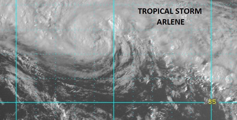
the latest satellite loop shows that the subtropical depression that became a tropical depression this morning is now TROPICAL STORM ARELENE. Strong convection has developed an increased around a very tight circulation center. Tropical Storm Arlene is moving northwest as it rotates around a strong non tropical cyclone to the northwest of the cyclone. Tropical Storm Arlene becomes only the second tropical storm in the month of April since storms have been named (1953). The other was Tropical Storm Ana in 2003 which formed as a subtropical storm west of Bermuda and moved northeastward. Tropical Storm Arlene will eventually be absorbed by the large cyclone to the northeast.
...RARE APRIL TROPICAL STORM FORMS IN THE NORTH ATLANTIC...
...STILL EXPECTED TO DISSIPATE ON FRIDAY...


SUMMARY OF 500 PM AST...2100 UTC...INFORMATION
----------------------------------------------
LOCATION...37.7N 42.0W
ABOUT 815 MI...1315 KM W OF THE AZORES
MAXIMUM SUSTAINED WINDS...45 MPH...75 KM/H
PRESENT MOVEMENT...WNW OR 290 DEGREES AT 25 MPH...41 KM/H
MINIMUM CENTRAL PRESSURE...993 MB...29.33 INCHES


WATCHES AND WARNINGS
--------------------
There are no coastal watches or warnings in effect.


DISCUSSION AND 48-HOUR OUTLOOK
------------------------------
At 500 PM AST (2100 UTC), the center of Tropical Storm Arlene was
located near latitude 37.7 North, longitude 42.0 West. Arlene is
moving toward the west-northwest near 25 mph (41 km/h), and this
general motion is expected to continue until dissipation on Friday.

Maximum sustained winds are near 45 mph (75 km/h) with higher gusts.
Arlene is forecast to become absorbed by a large extratropical low
and dissipate on Friday.

Tropical-storm-force winds extend outward up to 105 miles (165 km)
from the center.

The estimated minimum central pressure is 993 mb (29.33 inches).
MANY THANKS TO TROPICAL TIDBITS FOR THE WONDERFUL USE OF THE MAPS
WINTER 2016-2017 PART 1 OCEAN WATER TEMPERATURES
WINTER 2016-2017 PART 2 ARCTIC SEA ICE AND SIBERIAN SNOW COVER
WINTER 2016-2017 PART 3 NEW JERSEY PREVIEW
WINTER 2016-2017 PART 4 EASTERN PENNSYLVANIA PREVIEW
FiOS1 News Weather Forecast For Long Island
FiOS1 News Weather Forecast For New Jersey
FiOS1 News Weather Forecast For Hudson Valley
NATIONAL WEATHER SERVICE SNOW FORECASTS
LATEST JOESTRADAMUS ON THE LONG RANGE
Weather App

Don’t be without Meteorologist Joe Cioffi’s weather app. It is really a meteorologist app because you get my forecasts and my analysis and not some automated computer generated forecast based on the GFS model. This is why your app forecast changes every 6 hours. It is model driven with no human input at all. It gives you an icon, a temperature and no insight whatsoever.
It is a complete weather app to suit your forecast needs. All the weather information you need is right on your phone. Android or I-phone, use it to keep track of all the latest weather information and forecasts. This weather app is also free of advertising so you don’t have to worry about security issues with your device. An accurate forecast and no worries that your device is being compromised.
Use it in conjunction with my website and my facebook and twitter and you have complete weather coverage of all the latest weather and the long range outlook. The website has been redone and upgraded. Its easy to use and everything is archived so you can see how well Joe does or doesn’t do when it comes to forecasts and outlooks.
Just click on the google play button or the apple store button on the sidebar for my app which is on My Weather Concierge. Download the app for free. Subscribe to my forecasts on an ad free environment for just 99 cents a month.
Get my forecasts in the palm of your hand for less than the cost of a cup of Joe!
![]()
![]()