Tropical Development Likely Off SE US Coast
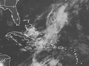
The chances for tropical storm development over the next five days continues to increase. Latest satellite loops are showing the area of disturbed weather east of the Bahamas becoming better organized. Low pressure is developing there and that low will track west or west northwestward toward the US Southeast Coast. This is pretty consistent with all weather models which have been showing this for the past 5 to 6 days. It is highly unusual to have a threat for a tropical storm for the Memorial Day holiday weekend but interests from North Carolina southward to Georgia are going to have to start paying closer attention.
Tropical Development Likely
SATELLITE LOOP

Tropical Development Likely
NATIONAL HURRICANE CENTER 5 DAY OUTLOOK

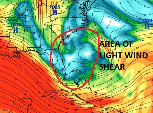
Water temperatures remain borderline on the latest observations. However the upper air profile off the southeast coast of the US continues to show favorable conditions for development with a decent outflow set up and an area of low wind shear.. The map below is the wind profile of the higher levels atmosphere above 25-30 thousand feet. Winds are forecast to be very light at that level and that is a key factor in tropical storm formation.
Tropical Development Likely
HIGH LEVEL WIND SHEAR FORECAST
We will monitor this of course and given the time of year, conditions have to really line up for tropical storm formation. It seems some of the pieces of the puzzle are there. Now it is a matter of how they come together.
HERE IS THE LATEST VIDEO ANALYSIS
LATEST FORECAST DISCUSSION ON THE HOLIDAY WEEKEND
FiOS1 News Weather Forecast For Long Island
FiOS1 News Weather Forecast For New Jersey
FiOS1 News Weather Forecast For Hudson Valley
NATIONAL WEATHER SERVICE SNOW FORECASTS
LATEST JOESTRADAMUS ON THE LONG RANGE

NOMINATED FOR AN APPY AWARD FOR BEST WEATHER APP!!
Weather App

Don’t be without Meteorologist Joe Cioffi’s weather app. It is really a meteorologist app because you get my forecasts and my analysis and not some automated computer generated forecast based on the GFS model. This is why your app forecast changes every 6 hours. It is model driven with no human input at all. It gives you an icon, a temperature and no insight whatsoever.
It is a complete weather app to suit your forecast needs. All the weather information you need is right on your phone. Android or I-phone, use it to keep track of all the latest weather information and forecasts. This weather app is also free of advertising so you don’t have to worry about security issues with your device. An accurate forecast and no worries that your device is being compromised.
Use it in conjunction with my website and my facebook and twitter and you have complete weather coverage of all the latest weather and the long range outlook. The website has been redone and upgraded. Its easy to use and everything is archived so you can see how well Joe does or doesn’t do when it comes to forecasts and outlooks.
Just click on the google play button or the apple store button on the sidebar for my app which is on My Weather Concierge. Download the app for free. Subscribe to my forecasts on an ad free environment for just 99 cents a month.
Get my forecasts in the palm of your hand for less than the cost of a cup of Joe!
![]()
