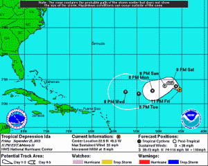
Conditions over the Atlantic remain fairly hostile overall but there is a small window that may be opening up for Tropical Depression Ida as it seems to be hanging on for now. Should it survive the day there is a chance that it could get into a more favorable environment for strengthening however as we have pointed out many times before, sheared systems have a hard time coming back once they get ripped up and the models have been forever showing shear relaxing and it just never seems to go away. Still we want to leave the door open slightly to that possibility. Ida may begin a more westward track over the next few days as a strong subtropical high builds across the Atlantic to the north of the system.
SUMMARY OF 500 AM AST...0900 UTC...INFORMATION
----------------------------------------------
LOCATION...23.4N 46.1W
ABOUT 1155 MI...1855 KM ENE OF THE NORTHERN LEEWARD ISLANDS
MAXIMUM SUSTAINED WINDS...35 MPH...55 KM/H
PRESENT MOVEMENT...NW OR 325 DEGREES AT 8 MPH...13 KM/H
MINIMUM CENTRAL PRESSURE...1006 MB...29.71 INCHES

Elsewhere we have 2 systems of note in the Atlantic. The first is east of the Bahamas where some thunderstorm activity has developed around an upper air low. Conditions are forecast to become unfavorable for development there in a day or 2 so this probably has no chance to becoming anything of consequence.

In the Gulf of Mexico and the Northwest Caribbean we have disorganized disturbed weather and low pressure will be developing there and heading northward however conditions here are not that favorable for development either over the weekend.
Check the latest marine forecast for our area and the local forecast . Small Craft Advisories are posted for us for the weekend as rough ocean conditions develop from an onshore flow.
Be sure to download my weather app and subscribe to my forecasts. The app is free and the subscription is just 99 cents a month. The app is free of advertisement and there are no tracking or security issues.


