Tropical Depression Could Form Soon
TROPICAL DEPRESSION COULD FORM SOON
MODELS FORECAST A TROPICAL STORM IN EASTERN CARIBBEAN

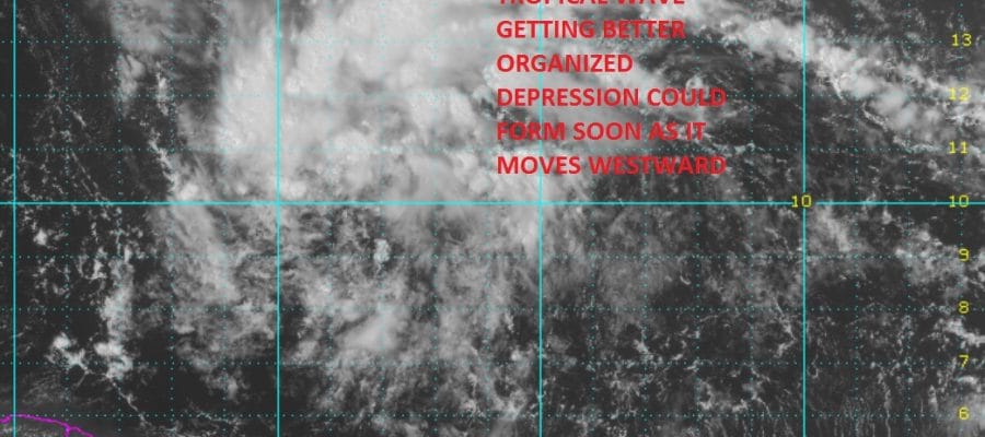
The satellite loop above shows the well defined tropical wave which continues to slowly get better organized. There appears to be the beginnings of a low level circulation developing as the wave continues to move to the west. The wave is currently along 10 degrees north so it is pretty far to the south. The wave is less than 600 miles east of the Windward Islands. Weather models are bullish on development into a tropical depression and then a Tropical Storm over the next several days.

On the wider satellite view you can see that this is a very large system embedded in a moist layer of air that exists south of 15 degrees north. Dry air is to the north however the moist shield is preventing that dry air from getting pulled further south. Conditions are quite favorable for this system to develop as it moves west. Wind shear appears minimal at this point. The National Hurricane Center has increased the odds of development into a tropical depression or tropical storm to 70 percent over the next 2 days and 90 percent over the next 5 days.
We continue to look at the afternoon runs of weather models which have been exceptionally volatile over the last week regarding the pattern across North America. This will impact what ultimately happens to this tropical system once it moves into the Eastern Caribbean. We will be posting more on this later today.
WINTER 2016-2017 PART 1 OCEAN WATER TEMPERATURES
WINTER 2016-2017 PART 2 ARCTIC SEA ICE AND SIBERIAN SNOW COVER
WINTER 2016-2017 PART 3 NEW JERSEY
WINTER 2016-2017 PART 4 PENNSYLVANIA
FiOS1 News Weather Forecast For Long Island
FiOS1 News Weather Forecast For New Jersey
FiOS1 News Weather Forecast For Hudson Valley
NATIONAL WEATHER SERVICE SNOW FORECASTS
LATEST JOESTRADAMUS ON THE LONG RANGE
Weather App

Don’t be without Meteorologist Joe Cioffi’s weather app. It is really a meteorologist app because you get my forecasts and my analysis and not some automated computer generated forecast based on the GFS model. This is why your app forecast changes every 6 hours. It is model driven with no human input at all. It gives you an icon, a temperature and no insight whatsoever.
It is a complete weather app to suit your forecast needs. All the weather information you need is right on your phone. Android or I-phone, use it to keep track of all the latest weather information and forecasts. This weather app is also free of advertising so you don’t have to worry about security issues with your device. An accurate forecast and no worries that your device is being compromised.
Use it in conjunction with my website and my facebook and twitter and you have complete weather coverage of all the latest weather and the long range outlook. The website has been redone and upgraded. Its easy to use and everything is archived so you can see how well Joe does or doesn’t do when it comes to forecasts and outlooks.
Just click on the google play button or the apple store button on the sidebar for my app which is on My Weather Concierge. Download the app for free. Subscribe to my forecasts on an ad free environment for just 99 cents a month.
Get my forecasts in the palm of your hand for less than the cost of a cup of Joe!
![]()
![]()