European Model On Developing Tropical System
European Model On Developing Tropical System
Many Questions On Longer Term North America Pattern

The satellite loop above shows the well defined tropical wave which continues to slowly get better organized. There appears to be the beginnings of a low level circulation developing as the wave continues to move to the west. The wave is currently along 10 degrees north so it is pretty far to the south. The wave is less than 600 miles east of the Windward Islands. Weather models are bullish on development into a tropical depression and then a Tropical Storm over the next several days.

SPECIAL THANKS TO TROPICAL TIDBITS FOR THE GREAT MAPS!
On the wider satellite view you can see that this is a very large system embedded in a moist layer of air that exists south of 15 degrees north. Dry air is to the north however the moist shield is preventing that dry air from getting pulled further south. Conditions are quite favorable for this system to develop as it moves west. Wind shear appears minimal at this point. The National Hurricane Center has increased the odds of development into a tropical depression or tropical storm to 70 percent over the next 2 days and 90 percent over the next 5 days.
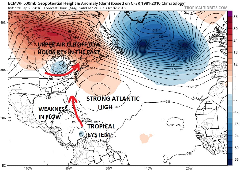
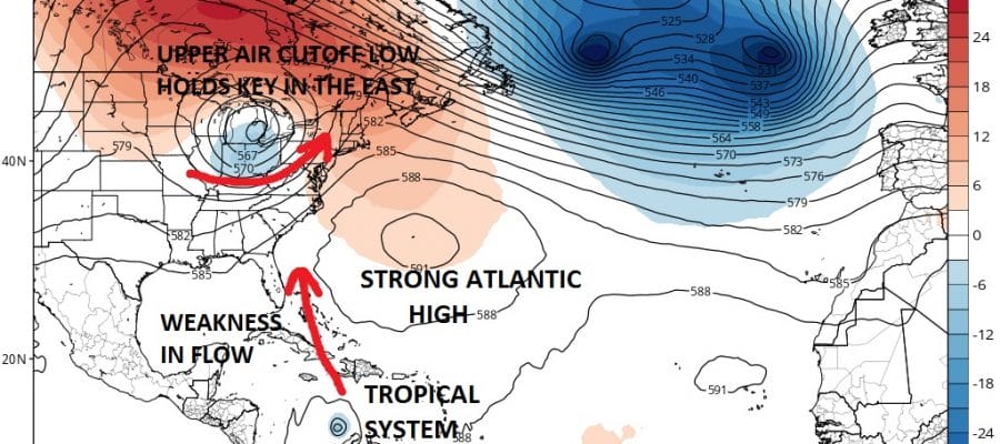
Now on to the European Model which today continues to enforce the notion that the upper low cut off in the Eastern and Midwest US will be the key to the forecast going forward. While the European model straddles the circulation of this system right along the coast of South America, it continues to advertise a northward turn. This is in response to the weakness in the upper flow that develops along the east coast and extends far south into the Caribbean.
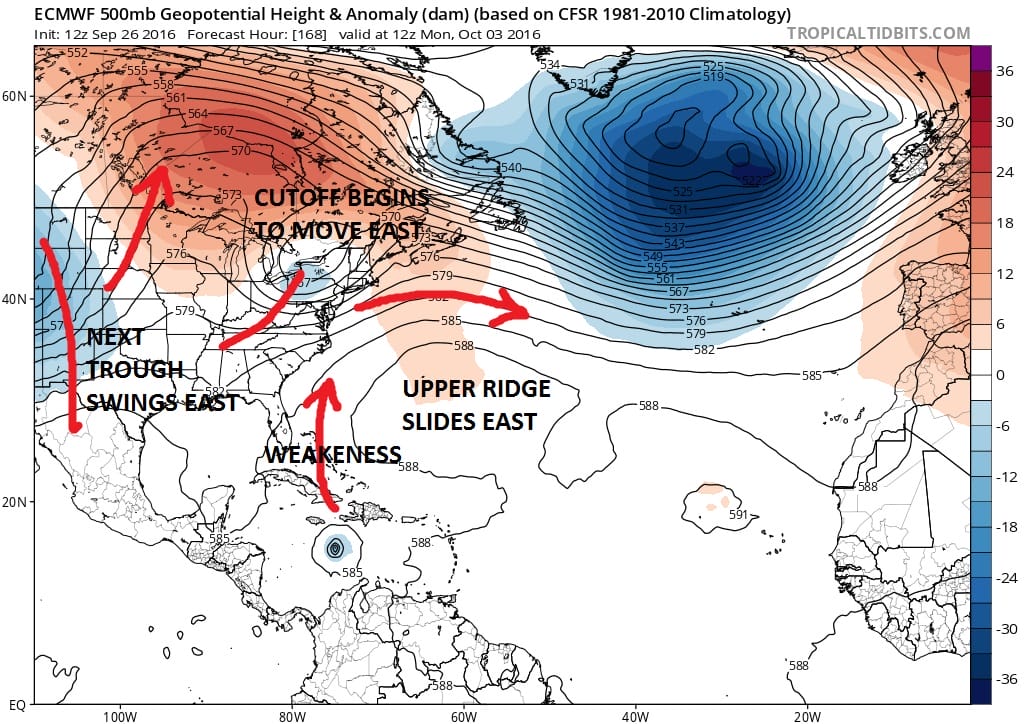
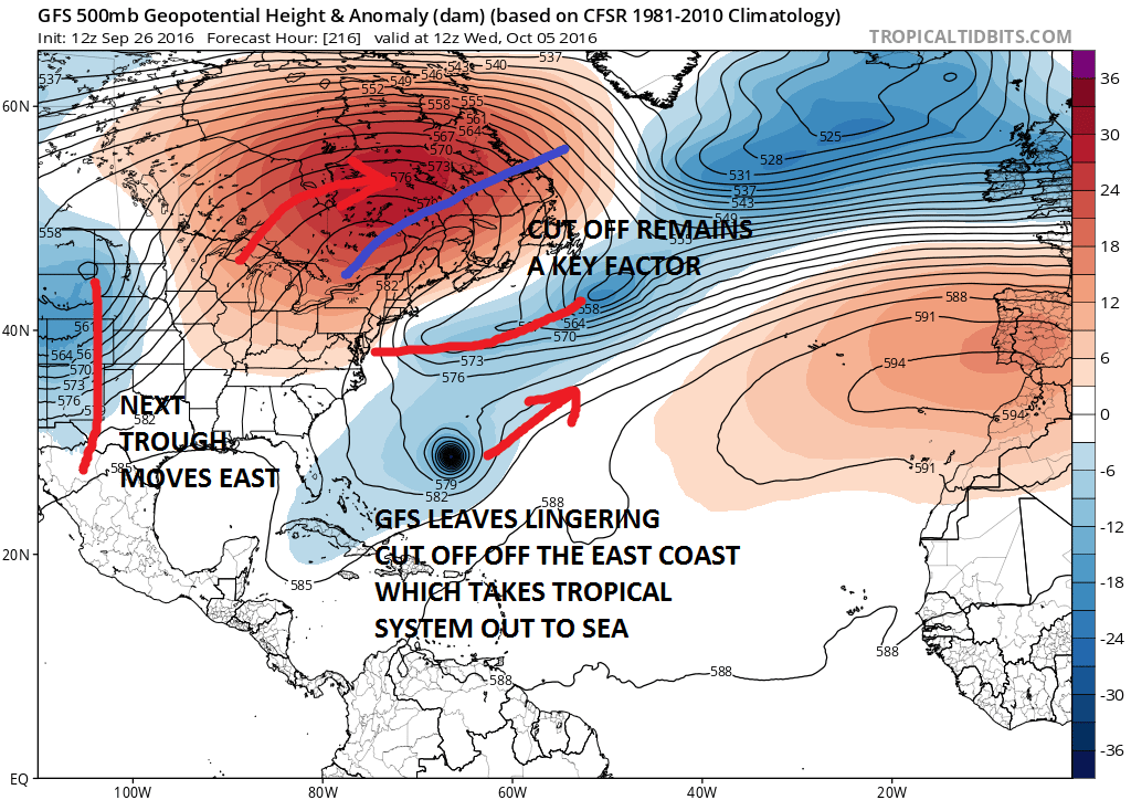
Unlike today’s GFS which lingers the cutoff low off the east coast, the European kicks it away to the northeast. This is VERY IMPORTANT in the longer term weather pattern in the east. We have been saying for days the importance of the cutoff low. The ejection to the east by the European (if it is correct) leaves no mechanism for the system to turn to the northeast and out to sea.

Now we should point out that there are a couple of other possibilites. One is that the system is so far south that it either gets ripped apart if it were to go inland into South America. Another possibility is that it misses the weakness along 80 degrees West and just continue to move Westward toward Central America. Below are the Spaghetti Plots for this storm as well as the GFS Ensembles.
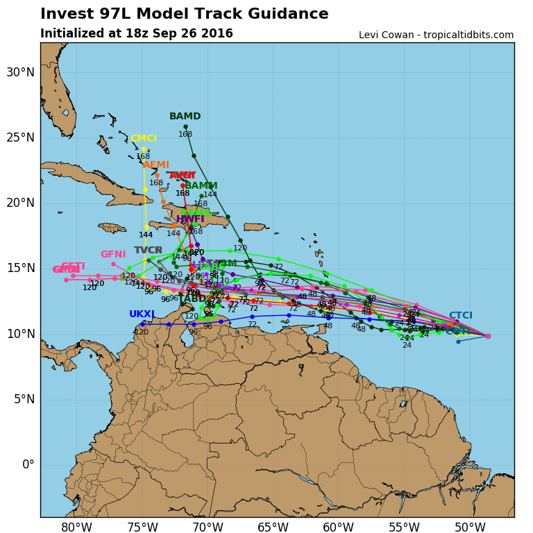
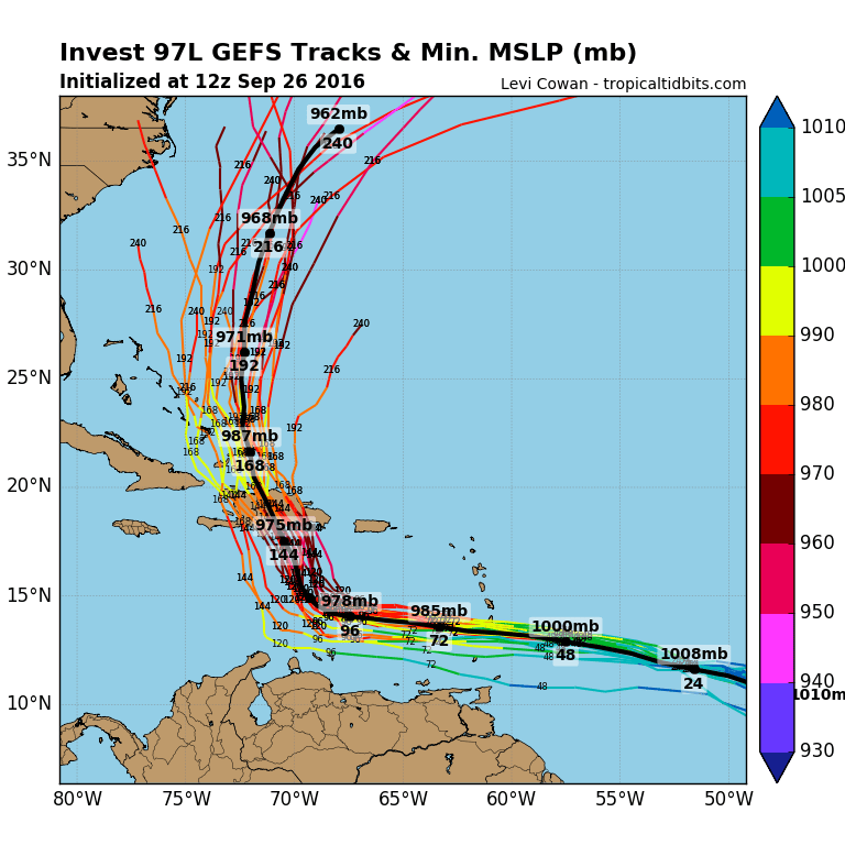
Notice on the GFS ensembles that today’s run has the system offshore but it is much further to the left (closer to the coast) then the operational run. Also the ensembles have the wave further north than the European model which would also make a difference in the final track. Clearly there isn’t much we can conclude from all this at this point but we will continue to follow it along as this system develops.
WINTER 2016-2017 PART 1 OCEAN WATER TEMPERATURES
WINTER 2016-2017 PART 2 ARCTIC SEA ICE AND SIBERIAN SNOW COVER
WINTER 2016-2017 PART 3 NEW JERSEY
WINTER 2016-2017 PART 4 PENNSYLVANIA
FiOS1 News Weather Forecast For Long Island
FiOS1 News Weather Forecast For New Jersey
FiOS1 News Weather Forecast For Hudson Valley
NATIONAL WEATHER SERVICE SNOW FORECASTS
LATEST JOESTRADAMUS ON THE LONG RANGE
Weather App

Don’t be without Meteorologist Joe Cioffi’s weather app. It is really a meteorologist app because you get my forecasts and my analysis and not some automated computer generated forecast based on the GFS model. This is why your app forecast changes every 6 hours. It is model driven with no human input at all. It gives you an icon, a temperature and no insight whatsoever.
It is a complete weather app to suit your forecast needs. All the weather information you need is right on your phone. Android or I-phone, use it to keep track of all the latest weather information and forecasts. This weather app is also free of advertising so you don’t have to worry about security issues with your device. An accurate forecast and no worries that your device is being compromised.
Use it in conjunction with my website and my facebook and twitter and you have complete weather coverage of all the latest weather and the long range outlook. The website has been redone and upgraded. Its easy to use and everything is archived so you can see how well Joe does or doesn’t do when it comes to forecasts and outlooks.
Just click on the google play button or the apple store button on the sidebar for my app which is on My Weather Concierge. Download the app for free. Subscribe to my forecasts on an ad free environment for just 99 cents a month.
Get my forecasts in the palm of your hand for less than the cost of a cup of Joe!
![]()
![]()