Tropical Depression 2 Forms Off SE US
Forecast to Strengthen Next 2 Days
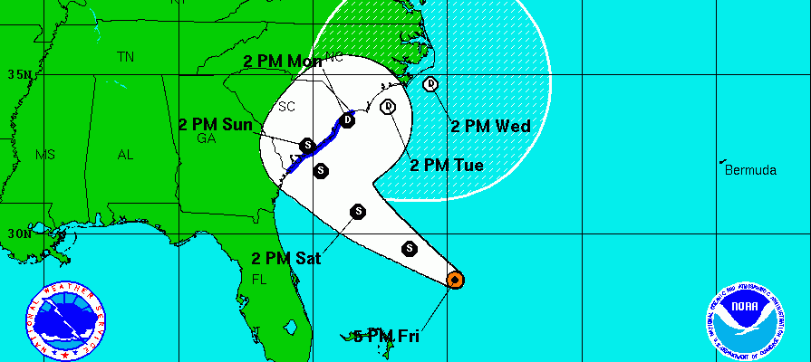
Latest observations from an Air Force aircraft indicate that the disturbed weather off the southeast coast has become better organized and Tropical Depression 2 has formed. Tropical Storm Warnings are posted for all of coastal South Carolina.
Tropical Depression 2 Forms Satellite Loop

Given the upper air conditions this could become a tropical storm before making landfall on Sunday somewhere along the South Carolina coast. If it does become a tropical storm it will be named Bonnie and this will be just the 5th time that we would have seen 2 named storms prior to the beginning of Hurricane season! Alex if you remember was back in January.
For us the issue is whether that moisture winds up being drawn up the eastern seaboard and ahead of a cold front. This would enhance the chance for showers here late Sunday night into Monday afternoon which puts Memorial Day in jeopardy. How much of this actually holds together remains to be seen.
The system is over cooler water at the moment and this is going to hold back development. Upper air winds are favorable with very low wind shear. Once the depression cross the warmer gulf stream it will have an opportunity to strengthen before landfall.
Tropical Depression 2 Forms
National Hurricane Center Forecast
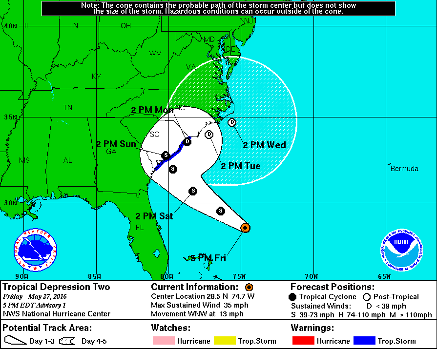
The National Hurricane Center’s forecast takes the actual center and just pretty much meanders it along the Carolina coast as it moves northeastward. Once it moves inland not much of the circulation will survive so it will be a matter of how the moisture responds to an approaching front to the northwest. Whatever the case I don’t think this is going to be a big deal regarding the moisture coming up here. If it does we will get some additional shower activity and that will be about it. Also this would be for late Sunday night into Monday afternoon and until then the holiday weekend should be okay for Saturday and Sunday.
FiOS1 News Weather Forecast For Long Island
FiOS1 News Weather Forecast For New Jersey
FiOS1 News Weather Forecast For Hudson Valley
NATIONAL WEATHER SERVICE SNOW FORECASTS
LATEST JOESTRADAMUS ON THE LONG RANGE
WEATHER APP

Don’t be without Meteorologist Joe Cioffi’s weather app. It is really a meteorologist app because you get my forecasts and my analysis and not some automated computer generated forecast based on the GFS model. This is why your app forecast changes every 6 hours. It is model driven with no human input at all. It gives you an icon, a temperature and no insight whatsoever.
It is a complete weather app to suit your forecast needs. All the weather information you need is right on your phone. Android or I-phone, use it to keep track of all the latest weather information and forecasts. This weather app is also free of advertising so you don’t have to worry about security issues with your device. An accurate forecast and no worries that your device is being compromised.
Use it in conjunction with my website and my facebook and twitter and you have complete weather coverage of all the latest weather and the long range outlook. The website has been redone and upgraded. Its easy to use and everything is archived so you can see how well Joe does or doesn’t do when it comes to forecasts and outlooks.
Just click on the google play button or the apple store button on the sidebar for my app which is on My Weather Concierge. Download the app for free. Subscribe to my forecasts on an ad free environment for just 99 cents a month.
Get my forecasts in the palm of your hand for less than the cost of a cup of Joe!
![]()
![]()

MENTION JOE CIOFFI AND GET A 5% DISCOUNT