Today The Best Weather Day This Week Weather Deteriorates Beginning Tuesday
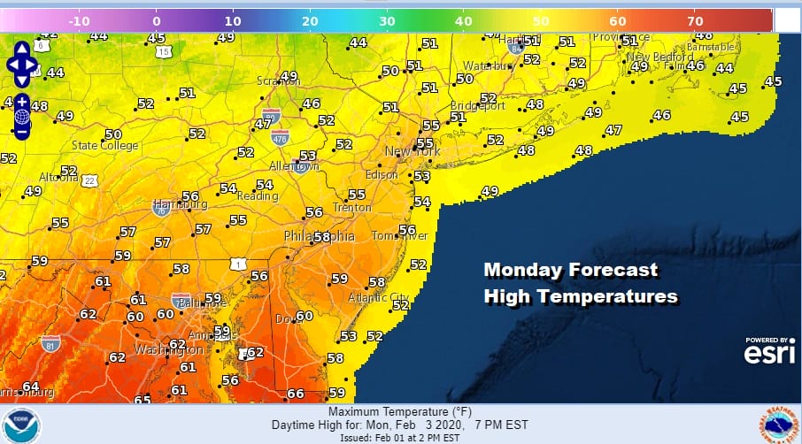
In terms of quality today is no doubt the best weather day of the week. Last night’s warm front with rain and snow showers has moved out to the northeast and all the precipitation is long gone. Skies have cleared out and we can look forward to a solid day of sunshine. Highs will reach the mid 50s in and around NYC and upper 50s to lower 60s Southern New Jersey & Southeastern Pennsylvania. To the northeast of NYC up the Hudson Valley and Connecticut, upper 40s and lower 50s will be the highs. Enjoy the day because the rest of the week is pretty much shot.
SATELLITE

REGIONAL RADAR

There are no issues this evening or tonight but we do have a cold front that will begin to approach on Tuesday with some showers moving through Tuesday morning, followed by a break in the action, and then a few more showers Tuesday night into Wednesday morning. Temperatures Tuesday will be lower than today due to the clouds and showers early on.

The front moves through Wednesday morning and temperatures will eventually settle into the 40s and 30s by mid to late afternoon. There could be a little mixed precipitation Wednesday afternoon followed by more widespread precipitation later Wednesday night into Thursday morning.

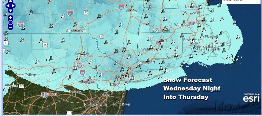
Once again we are dealing with marginal cold air that will be in the process of pulling out Thursday morning. However some freezing rain and sleet issues are possible from Southern Pennsylvania northeast to Southern New England from this first wave with snow further north. Below are the early snow and ice forecast maps through Thursday morning 7am. Amounts north of NYC will likely go higher as the time frame expands later today.


Unless there is more cold air in play, a coating to an inch or so of snow and sleet is possible from this first wave. The second wave for later Thursday night into Friday is rain and I think it could be heavy rain on the order of 1 to 2 inches for some areas. Low pressure will be moving up the coast with a lot of moisture. Snow will be confined to areas well north and west of the coast in Western NY and parts of Western Pennsylvania. There might even be a few thunderstorms in the mix with this.

Once this plays through weather conditions will improve Friday night into Saturday as it turns colder. Sunday may offer the an opportunity for snow lovers. We have talked about the fact that in this pattern, the only way it can snow from start to finish is if you get a weather system to move through timed with cold air to the north just perfectly. There are some hints that this could happen on Sunday though given the winter the odds are certainly long. We will discuss this further on our weather platform on Patreon in our Weather in 10 video later today.
BE SURE TO DOWNLOAD THE FREE METEOROLOGIST JOE CIOFFI WEATHER APP &
ANGRY BEN’S FREE WEATHER APP “THE ANGRY WEATHERMAN!
MANY THANKS TO TROPICAL TIDBITS FOR THE USE OF MAPS
Please note that with regards to any severe weather, tropical storms, or hurricanes, should a storm be threatening, please consult your local National Weather Service office or your local government officials about what action you should be taking to protect life and property.


