Thunderstorms This Evening Some Severe Possible
Weather Improves Sunday Week Ahead Outlook

Thunderstorms This Evening Some Severe Possible
Weather Improves Sunday Week Ahead Outlook
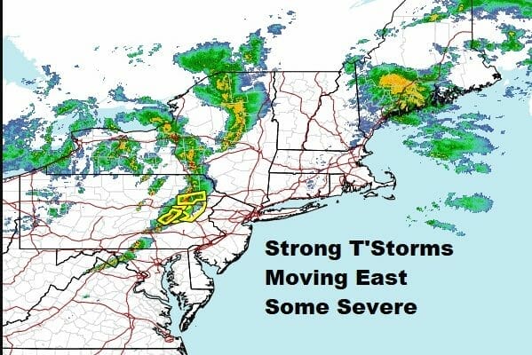
We are watching a line of thunderstorms moving through Eastern Pennsylvania and there are some strong cells embedded in this line. As of 5:45pm eastern time no severe thunderstorm watch has been posted. However we have seen a couple of warnings go up in the last hour so in Pennsylvania so whether the watch goes up or not, be on the lookout for thunderstorms later this evening into the first part of tonight over Eastern Pennsylvania, Western New Jersey especially Northern New Jersey to parts of the Hudson Valley and the Catskills. Strong gusty winds are the biggest risk from these thunderstorms though a 2 to 5 percent tornado risk has been indicated by the Storm Prediction Center.
SATELLITE

WEATHER RADAR

For areas close to NYC and points east the sea breeze has come in so thunderstorms should weaken as they pass through this area. While a rumble or two of thunder is likely and a brief period of heavy rain and gusty winds, they should not be up to severe weather criteria.

Sunday will be a cooler day inland with temperatures down from today’s to highs in the 50s to near 60. The coast and areas from Long Island and Southern New England, it will actually be a slightly warmer day since there won’t be a sea breeze issue. Highs here will be in the upper 50s to around 60. Look for a mix of sun and clouds with the outside chance for a passing brief isolated shower. That risk lasts into Sunday night until an upper trough passes. That leaves us with a nice day Monday with sunshine. Highs will reach into the 60s in most places. A weak front goes Monday night leaving us cooler Tuesday with some sunshine. Highs will be ni the upper 40s and lower 50s.

The next storm systems heads from the Southern Plains to the Great Lakes Wednesday and that means clouds for us. Another warm front approaches with some rain ahead of it later Wednesday into Thursday. We should see improving weather conditions later Thursday and Thursday night as a cold front moves offshore and that leaves us dry and cooler at the end of the week. This storm is going to produce widespread severe weather across East Texas and the Central Gulf Coast Monday and Tuesday.
BE SURE TO DOWNLOAD THE FREE METEOROLOGIST JOE CIOFFI WEATHER APP &
ANGRY BEN’S FREE WEATHER APP “THE ANGRY WEATHERMAN!
MANY THANKS TO TROPICAL TIDBITS & F5 WEATHER FOR THE USE OF MAPS
Please note that with regards to any severe weather, tropical storms, or hurricanes, should a storm be threatening, please consult your local National Weather Service office or your local government officials about what action you should be taking to protect life and property.


