Thunderstorms Approaching New Jersey NYC
Thunderstorms Approaching New Jersey NYC
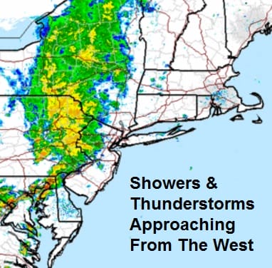
We have a cold front approaching the coast and it is triggering off widespread showers with a few embedded thunderstorms. The line is moving to the east and the satellite loop shows an upper air disturbance moving across the Great Lakes as the primary driver. Behind the front is the delightful air mass that will be here for the first part of next week but first we have some work to do.

Right now the radar seems to be showing the more active thunderstorms to be setting up across extreme Southern Pennsylvania and Maryland and this area could be in line for Southern New Jersey this evening. Right now the northern area appears less developed but some individual strong cells could pop up in this band in the next few hours as it moves east. The line is moving rather slowly so at least some areas will get some beneficial rains that will have time to soak in.


 As of right now there are no severe thunderstorm watches and the only warnings we have seen so far is around the Chesapeake Bay area where there have been some special marine warnings. I suspect we could see some warnings here. We will of course monitor all areas just in case a warning is issue and will broadcast them live on facebook.
Monday through Wednesday look like 3 great days with lots of sun, low humidity and pleasant temperatures in the upper 70s to around 80 or so by day and 50s to lower 60s at night!!!
FiOS1 News Weather Forecast For Long Island
FiOS1 News Weather Forecast For New Jersey
FiOS1 News Weather Forecast For Hudson Valley
NATIONAL WEATHER SERVICE SNOW FORECASTS
LATEST JOESTRADAMUS ON THE LONG RANGE
Weather App

Don’t be without Meteorologist Joe Cioffi’s weather app. It is really a meteorologist app because you get my forecasts and my analysis and not some automated computer generated forecast based on the GFS model. This is why your app forecast changes every 6 hours. It is model driven with no human input at all. It gives you an icon, a temperature and no insight whatsoever.
It is a complete weather app to suit your forecast needs. All the weather information you need is right on your phone. Android or I-phone, use it to keep track of all the latest weather information and forecasts. This weather app is also free of advertising so you don’t have to worry about security issues with your device. An accurate forecast and no worries that your device is being compromised.
Use it in conjunction with my website and my facebook and twitter and you have complete weather coverage of all the latest weather and the long range outlook. The website has been redone and upgraded. Its easy to use and everything is archived so you can see how well Joe does or doesn’t do when it comes to forecasts and outlooks.
Just click on the google play button or the apple store button on the sidebar for my app which is on My Weather Concierge. Download the app for free. Subscribe to my forecasts on an ad free environment for just 99 cents a month.
Get my forecasts in the palm of your hand for less than the cost of a cup of Joe!

MENTION JOE CIOFFI AND GET A 5% DISCOUNT


