Low Humidity Sunshine Arrive
Low Humidity Sunshine Arrive
With last night’s cold front long gone, we are in the throws of a nice dry air mass and dew points this morning are already falling through the 60s. It should be a nice partly to mostly sunny day with highs in the upper 70s to lower 80s. No weather issues at all other than a few passing clouds. Skies tonight will be mostly clear and it will be a nice cool night with lows in the mid 50s to lower 60s. Satellite loop is pretty quiet and the radars will be silent around here for a couple of days.


Late Week OutLook
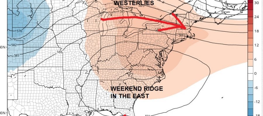
Tropical Storm Off Southeast Coast?
There really isn’t too much happening this week. Low humidity should last into Wednesday. The next cold front will be a weak one and move through Thursday night. I don’t believe there will be much with that front. Then another dry air mass builds in from the north with low humidity but the push won’t be as strong as this one. Still it will keep us out of any kind of heat or humidity at least into the weekend. Also by the weekend models are pushing the idea of something tropical off the southeast coast of the US.
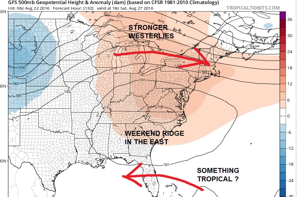
If this is true it would be hard to envision a problem for the Middle Atlantic or the northeast with a ridge in this position in the Carolinas. Strong westerlies are lying to the north of that. Anything tropical if this is right would suggest something going westward or possibly even northeastward depending on where it is with respect to that ridge. More on this later today when we see afternoon weather models. In the meantime if you haven’t seen it, here is last night’s tropical weather video. A new video will be posted this afternoon.
FiOS1 News Weather Forecast For Long Island
FiOS1 News Weather Forecast For New Jersey
FiOS1 News Weather Forecast For Hudson Valley
NATIONAL WEATHER SERVICE SNOW FORECASTS
LATEST JOESTRADAMUS ON THE LONG RANGE
Weather App

Don’t be without Meteorologist Joe Cioffi’s weather app. It is really a meteorologist app because you get my forecasts and my analysis and not some automated computer generated forecast based on the GFS model. This is why your app forecast changes every 6 hours. It is model driven with no human input at all. It gives you an icon, a temperature and no insight whatsoever.
It is a complete weather app to suit your forecast needs. All the weather information you need is right on your phone. Android or I-phone, use it to keep track of all the latest weather information and forecasts. This weather app is also free of advertising so you don’t have to worry about security issues with your device. An accurate forecast and no worries that your device is being compromised.
Use it in conjunction with my website and my facebook and twitter and you have complete weather coverage of all the latest weather and the long range outlook. The website has been redone and upgraded. Its easy to use and everything is archived so you can see how well Joe does or doesn’t do when it comes to forecasts and outlooks.
Just click on the google play button or the apple store button on the sidebar for my app which is on My Weather Concierge. Download the app for free. Subscribe to my forecasts on an ad free environment for just 99 cents a month.
Get my forecasts in the palm of your hand for less than the cost of a cup of Joe!

MENTION JOE CIOFFI AND GET A 5% DISCOUNT