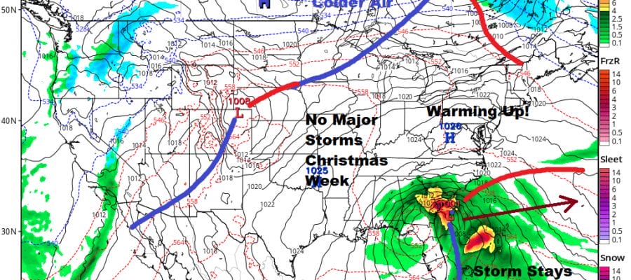
Temperatures Moderate into Next Week No Major Storms or Minor Ones Through Christmas
Long dry stretches of weather lasting a week or more don’t happen often but they do show up from time to time. We are in one such stretch now as Hanukkah and Christmas near. This is actually a good thing through White Christmas fans will be sorely disappointed. The last several Christmas’s have seen above normal temperatures including the air conditioner Christmas of 2015 when temperatures hit the 70s. We have been on a downtrend ever since. Our cold air mass over us now is actually getting a slight re-enforcement from high pressure to the north. We still should see temperature recovery today into the 30s with a good deal of sunshine and not a whole lot of wind.
SATELLITE

REGIONAL RADAR

There is nothing on the regional radar and the radars will be taking a holiday vacation from now right through Christmas Day. Tonight will be clear and cold with lows in the teens to low 20s. Saturday will be a nice day of sunshine with highs in the mid to upper 30s. Temperatures will rebound into the 40s on Sunday with a fair amount of sunshine so it looks like a nice weekend.
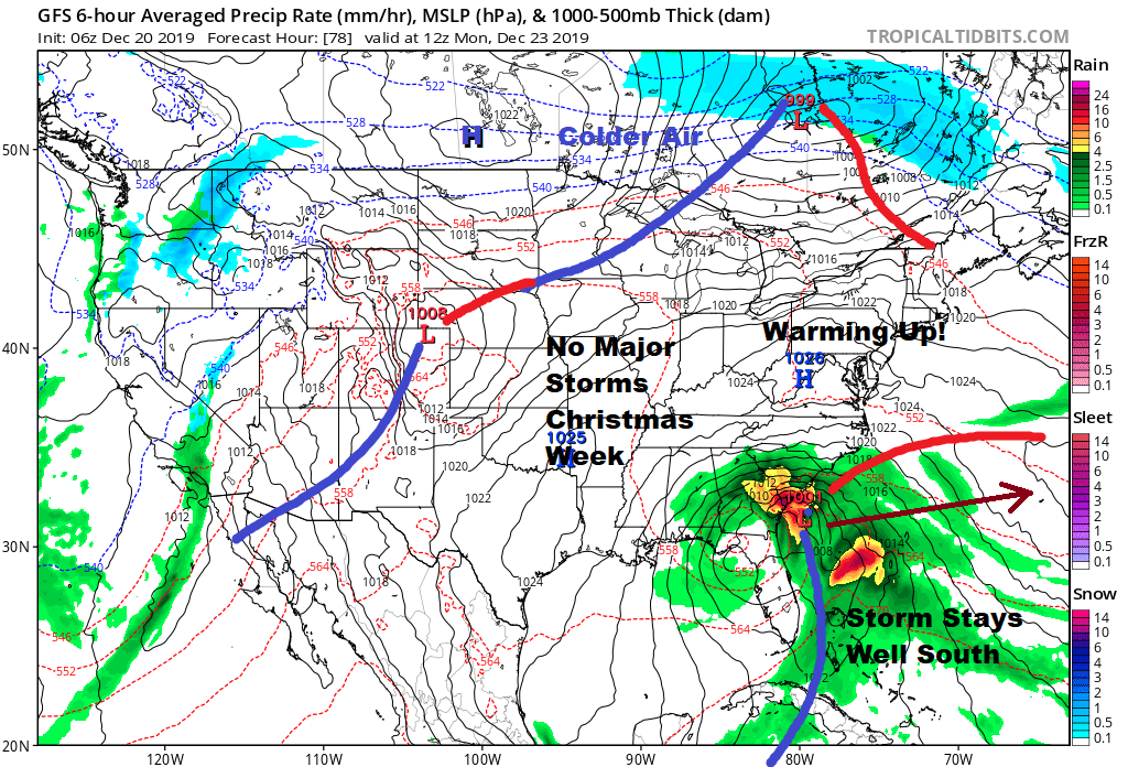
There is going to be a storm moving over the Northeast Gulf of Mexico & North Florida and then off the Southeast coast of the US bringing heavy rains from the coastal Carolinas southward to Florida but there is no mechanism to bring that storm up the East Coast. Instead we will see some sunshine, a west wind on Monday and highs that will reach into the 50s in many locations. Tuesday Christmas Eve will be dry with some sunshine and still on the mild side with highs in the mid to upper 40s. A back door cold front will move through making for a cooler but still nice Christmas Day with some sun and clouds and highs in the low to mid 40s. The next weather system of any importance is a weak one next Thursday where we will have an onshore wind and lots of clouds. Perhaps there could be a rain or snow shower on that day. Then a stronger cold front will make a better chance for showers but that won’t be until next Sunday.
Since the weather is rather quiet these next 5 days, the websites and apps will be updated once a day as we all enjoy some nice holiday time. I may feel inspired to do a long range post or two at some point. In the meantime enjoy these days leading into Hanukkah and Christmas. They come once a year and they are important moments in our lives. Take a break from the phone too!
BE SURE TO DOWNLOAD THE FREE METEOROLOGIST JOE CIOFFI WEATHER APP &
ANGRY BEN’S FREE WEATHER APP “THE ANGRY WEATHERMAN!
MANY THANKS TO TROPICAL TIDBITS FOR THE USE OF MAPS
Please note that with regards to any severe weather, tropical storms, or hurricanes, should a storm be threatening, please consult your local National Weather Service office or your local government officials about what action you should be taking to protect life and property.


