The offshore low that brought clouds and even some showers to parts of the area (mainly the coast) yesterday is

The offshore low that brought clouds and even some showers to parts of the area (mainly the coast) yesterday is
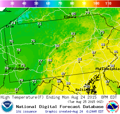
This has been the way things have been working for months. Another cold front is approaching and it will probably

Joestradamus is looking at model guidance that continues to flip flop in all sorts of directions and run to run

Afternoon satellite pics and other data pretty much confirm what we saw beginning Friday night that Danny was weakening and

…TROPICAL STORM WARNING ISSUED FOR PORTIONS OF THE LEEWARDISLANDS… SUMMARY OF 500 AM AST…0900 UTC…INFORMATION ———————————————- LOCATION…15.8N 56.0W ABOUT 360

SUMMARY OF 500 PM AST…2100 UTC…INFORMATION ———————————————- LOCATION…15.8N 53.3W ABOUT 570 MI…915 KM E OF THE LEEWARD ISLANDS MAXIMUM SUSTAINED