Super Bowl Sunday Winter Weather Advisory NE Pennsylvania Catskills

Super Bowl Sunday Winter Weather Advisory
NE Pennsylvania Catskills
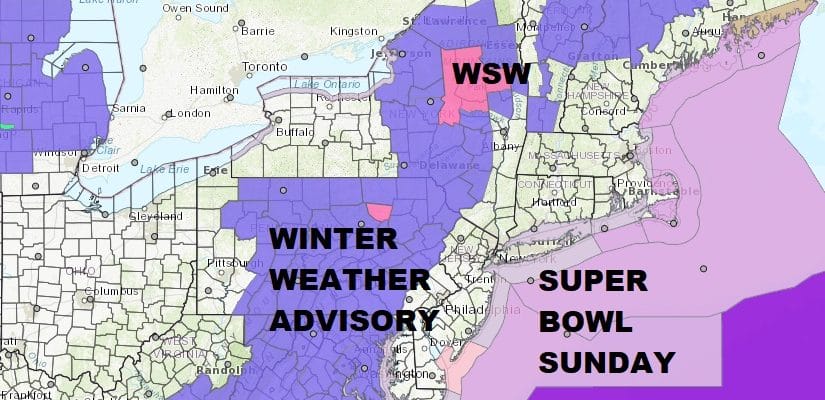
There have been no major changes overnight with Winter Weather Advisories. They continue across Northeast Pennsylvania into the Catskills. Everything is running on course this morning. Clouds are everywhere and there is scattered precipitation around this morning on the radar. The bulk of the precipitation will be coming later this afternoon and tonight as it moves up from the south.

Low pressure over Southeastern Canada and a secondary low developing to the south off the Delaware Coast will bring an inch or so of rain. Snow for inland areas is possible at the start across Northwest New Jersey before it goes to rain. In the Winter Weather Advisory area look for up to several inches of snow to accumulate before it goes over to rain.
US SATELLITE

REGIONAL RADAR

Local radars are seeing some activity this morning but you can see on the regional radar above there is an area of widespread precipitation in Western Virginia and Western North Carolina pushing northeastward.
LOCAL RADAR NEW YORK CITY

LOCAL RADAR PHILADELPHIA


Rain tonight should end after midnight with leftover clouds to follow. Temperatures today will head into the 40s and then drop into the 30s by morning. Monday will be cold and windy at times with some sunshine. Temperatures will hold in the 30s. Tuesday will be dry sunny and cold. Then we do it all over again on Wednesday as another storm system comes into the east in much the same way as this one did. That means mostly a rain event with a little snow or mix at the start when precipitation arrives.
 GET JOE A CIGAR IF YOU LIKE

FiOS1 News Weather Forecast For Long Island
FiOS1 News Weather Forecast For New Jersey
FiOS1 News Weather Forecast For Hudson Valley


