
Sunshine Wind Cooler Temperatures

Sunshine Wind Cooler Temperatures
We begin the day with sunshine across most of the area along with a nice breeze and temperatures in the 50s to near 60 this morning. To the northwest we have some clouds that will probably come into the mix as the day wears on. it will also get a bit breezy again with a few wind gusts over 30 mph later today. Overall a decent early May day. To the southwest we see the beginnings of low pressure developing in the Southern Plains which will be producing severe weather today across the Gulf States. This will be our big rain producer for Friday. No weather issues however through Thursday evening. Skies tonight should be nice and clear with lows in the 40s. Thursday we will see sunshine give way to arriving clouds with highs reaching into the 60s. Radars should be quiet today though there will be some showers popping up well north and west of the coast.
SATELLITE LOOP

REGIONAL RADAR

LOCAL RADAR NEW YORK CITY

LOCAL RADAR PHILADELPHIA


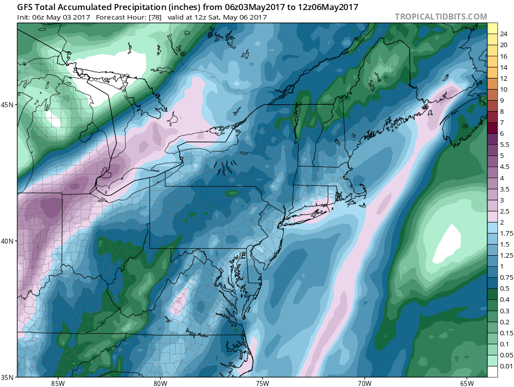
Rain will be the story beginning during the early morning hours on Friday and lasting into Friday night. As always with these systems every model has a different view of rain amounts. I think the idea of a solid 1 to 2 inch rainfall from Southeastern Pennsylvania to Southern New England and everyone in between looks like a good bet to me.
GFS FORECAST RAIN AMOUNTS THROUGH SATURDAY MORNING MAY 6 2017
As for the weekend right now it looks quite unsettled with a cold unstable atmosphere and a strong upper air storm sitting on top of us. This will mean the chance for showers right through Sunday though there will be dry periods and some places may not see much if any while others will see more than there fair share. Temperatures will be in the 60s Friday but then only in the 50s to near 60 over the weekend.
 GET JOE A CIGAR IF YOU LIKE

LANDSCAPE COMPANIES FOR YOUR NEEDS
LONG ISLAND ROCKLAND COUNTY Connecticut

![]()

ROCKLAND COUNTY TRI STATE SNOW REMOVAL JOHNSTOWN PA


FiOS1 News Weather Forecast For Long Island
FiOS1 News Weather Forecast For New Jersey
FiOS1 News Weather Forecast For Hudson Valley
NATIONAL WEATHER SERVICE SNOW FORECASTS
LATEST JOESTRADAMUS ON THE LONG RANGE
Weather App

Don’t be without Meteorologist Joe Cioffi’s weather app. It is really a meteorologist app because you get my forecasts and my analysis and not some automated computer generated forecast based on the GFS model. This is why your app forecast changes every 6 hours. It is model driven with no human input at all. It gives you an icon, a temperature and no insight whatsoever.
It is a complete weather app to suit your forecast needs. All the weather information you need is right on your phone. Android or I-phone, use it to keep track of all the latest weather information and forecasts. This weather app is also free of advertising so you don’t have to worry about security issues with your device. An accurate forecast and no worries that your device is being compromised.
Use it in conjunction with my website and my facebook and twitter and you have complete weather coverage of all the latest weather and the long range outlook. The website has been redone and upgraded. Its easy to use and everything is archived so you can see how well Joe does or doesn’t do when it comes to forecasts and outlooks.
Just click on the google play button or the apple store button on the sidebar for my app which is on My Weather Concierge. Download the app for free. Subscribe to my forecasts on an ad free environment for just 99 cents a month.
Get my forecasts in the palm of your hand for less than the cost of a cup of Joe!


