
Heavy Rain Moving Northeast Friday Showers Weekend

Heavy Rain Moving Northeast Friday Showers Weekend
Everything remains on course for a shot of heavy rain for Friday. Until then we are going to be dry through Thursday evening with rain arriving during the early morning hours on Friday. Low pressure is currently developing over the Southern Plains and headed northeast. Severe weather is breaking out today across much of the Central Gulf States.
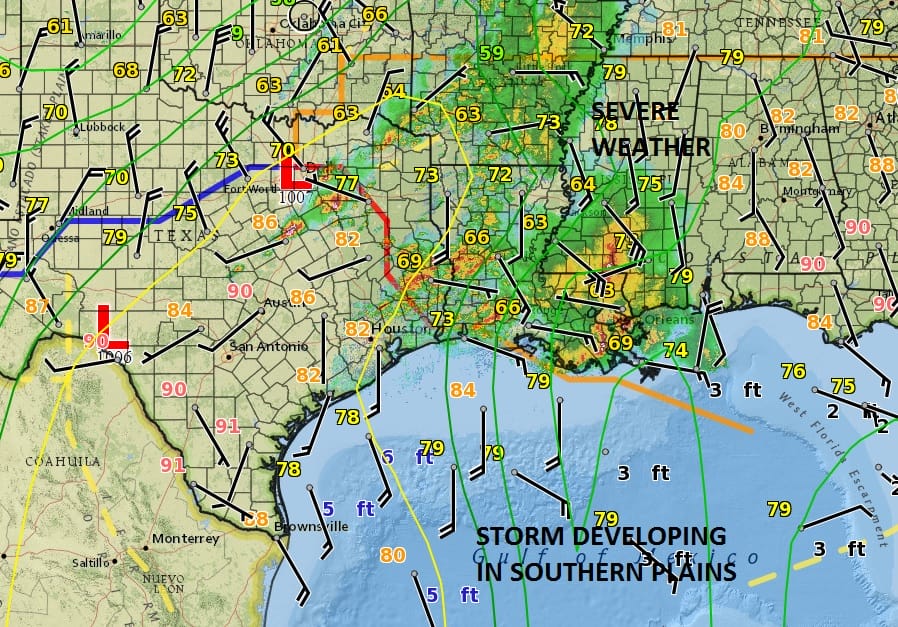
This system is seeing some strong inflow developing from the Gulf of Mexico. The low will track northeast into the Tennessee and Ohio Valley before making its way to the west side of the Appalachians. This looks like a 1 to 2 inch rain producer and that part of the forecast remains the same. There should be a shot of rain during Friday morning and then a heavier shot during the afternoon and evening. Weather models are all pretty consistent with this idea. As always some areas could get a bit more and some a bit less.
HEAVY RAIN GFS RAINFALL FORECAST THROUGH SATURDAY MORNING 8AM

Once the low moves into upstate NY it is going to slow down and stall which will create a lot of instability over the weekend. This means that the chance for showers continues through Sunday. Each morning could start dry before showers build up The weekend showers will tend to be more scattered in nature rather than widespread but they will be around. Some places will get more than others and some could escape them.
GFS RAINFALL SATURDAY AND SUNDAY
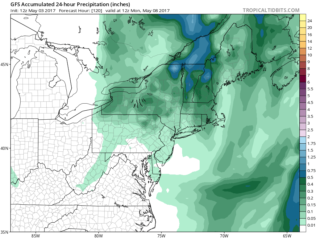
Note that the rainfall amounts for the weekend total under a quarter of an inch for the entire region with heavier rains to the north. In fact elevated areas well to the north might be cold enough for wet snow.

The colder air for the weekend for our area will probably keep temperature in the 60s on Saturday and more like upper 50s and lower 60s on Sunday. With the blocking continuing longer term, cool air, clouds, and the chance for showers will continue on and off next week.
MANY THANKS TO TROPICAL TIDBITS FOR THE WONDERFUL USE OF THE MAPS

GET JOE A CIGAR IF YOU LIKE!
LANDSCAPE COMPANIES FOR YOUR SPRING SUMMER FALL NEEDS
LONG ISLAND ROCKLAND COUNTY Connecticut

![]()

ROCKLAND COUNTY TRI STATE SNOW REMOVAL JOHNSTOWN PA


FiOS1 News Weather Forecast For Long Island
FiOS1 News Weather Forecast For New Jersey
FiOS1 News Weather Forecast For Hudson Valley
NATIONAL WEATHER SERVICE SNOW FORECASTS
LATEST JOESTRADAMUS ON THE LONG RANGE
Weather App

Don’t be without Meteorologist Joe Cioffi’s weather app. It is really a meteorologist app because you get my forecasts and my analysis and not some automated computer generated forecast based on the GFS model. This is why your app forecast changes every 6 hours. It is model driven with no human input at all. It gives you an icon, a temperature and no insight whatsoever.
It is a complete weather app to suit your forecast needs. All the weather information you need is right on your phone. Android or I-phone, use it to keep track of all the latest weather information and forecasts. This weather app is also free of advertising so you don’t have to worry about security issues with your device. An accurate forecast and no worries that your device is being compromised.
Use it in conjunction with my website and my facebook and twitter and you have complete weather coverage of all the latest weather and the long range outlook. The website has been redone and upgraded. Its easy to use and everything is archived so you can see how well Joe does or doesn’t do when it comes to forecasts and outlooks.
Just click on the google play button or the apple store button on the sidebar for my app which is on My Weather Concierge. Download the app for free. Subscribe to my forecasts on an ad free environment for just 99 cents a month.
Get my forecasts in the palm of your hand for less than the cost of a cup of Joe!
![]()
